欢迎访问《农学学报》,
农学学报 ›› 2026, Vol. 16 ›› Issue (1): 24-32.doi: 10.11923/j.issn.2095-4050.cjas2024-0161
陈岚1,2,3( ), 王成宝2,3, 杨思存1,2,3(), 罗珠珠1, 霍琳2,3, 温美娟2,3
收稿日期:2024-07-30
修回日期:2024-12-23
出版日期:2026-01-15
发布日期:2026-01-15
通讯作者:
作者简介:陈岚,女,1996年出生,重庆潼南人,硕士研究生,主要从事土壤养分资源管理研究。通信地址:730070 甘肃省兰州市安宁区银滩路甘肃农业大学,Tel:0931-7632496,E-mail:597518777@qq.com。
基金资助:
CHEN Lan1,2,3(), WANG Chengbao2,3, YANG Sicun1,2,3(), LUO Zhuzhu1, HUO Lin2,3, WEN Meijuan2,3
Received:2024-07-30
Revised:2024-12-23
Online:2026-01-15
Published:2026-01-15
摘要:
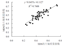
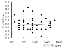
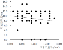
合理耕层对农作物的高产稳产有重要影响,其评价体系是构建合理耕层的理论依据,但目前适宜引黄灌区水浇地的耕层评价体系尚未建立。本研究采用相关性分析与主成分分析法对甘肃引黄灌区180个玉米地耕层土壤样品进行分析,筛选适宜该区水浇地的耕层评价指标并建立评价体系。结果表明:确定了影响耕层土壤质量的最小数据集(MDS)包括:耕层深度、犁底层厚度、>0.25 mm水稳性团聚体、速效氮、速效磷、速效钾;通过分析全量数据集耕层土壤质量指数(SQI-TDS)与最小数据集耕层土壤质量指数(SQI-MDS)相关性,证实了最小数据集评价指标的合理性;基于玉米产量与关键指标的响应关系,获得了指标的下限与上限参考值。引黄灌区水浇地合理耕层评价指标体系及取值范围是:耕层深度(22.2~22.7 cm)、犁底层厚度(6~8.6 cm)、>0.25 mm水稳性团聚体(13.9%~16.3%)、速效氮(70.41~99.81 mg/kg)、速效磷(17.34~30.84 mg/kg)、速效钾(169.9~172.6 mg/kg)。这一体系可为当地农户合理耕作施肥、建立适宜耕层及高标准农田建设提供参考依据。
陈岚, 王成宝, 杨思存, 罗珠珠, 霍琳, 温美娟. 基于主成分分析的引黄灌区水浇地合理耕层评价指标体系构建[J]. 农学学报, 2026, 16(1): 24-32.
CHEN Lan, WANG Chengbao, YANG Sicun, LUO Zhuzhu, HUO Lin, WEN Meijuan. Construction of Evaluation Index System for Reasonable Plough Layer of Irrigated Land in Yellow River Irrigation District Based on Principal Component Analysis[J]. Journal of Agriculture, 2026, 16(1): 24-32.
| 耕层指标 | 最小值 | 最大值 | 平均值 | 标准差 | 变异系数/% | |||
|---|---|---|---|---|---|---|---|---|
| 耕层深度/cm | 16.0 | 32.0 | 22.5 | 3.20 | 14.14 | |||
| 犁底层厚度/cm | 0.00 | 15.0 | 9.10 | 3.50 | 37.99 | |||
| 土壤容重/(g/cm3) | 1.21 | 1.58 | 1.39 | 0.08 | 5.86 | |||
| 土壤紧实度/kPa | 443 | 2199 | 1235 | 379 | 30.67 | |||
| >0.25 mm水稳性团聚体/% | 10.98 | 25.14 | 14.94 | 2.59 | 17.35 | |||
| 土壤有机质/(g/kg) | 8.40 | 16.30 | 12.3 | 1.90 | 15.39 | |||
| 全氮/(g/kg) | 0.32 | 1.40 | 0.93 | 0.19 | 20.53 | |||
| 全磷/(g/kg) | 0.54 | 1.67 | 0.92 | 0.19 | 20.28 | |||
| 全钾/(g/kg) | 19.6 | 24.60 | 22.0 | 1.10 | 5.22 | |||
| 速效氮/(mg/kg) | 26.50 | 132 | 88.9 | 22.9 | 25.79 | |||
| 速效磷/(mg/kg) | 7.80 | 49.60 | 25.9 | 10.2 | 39.46 | |||
| 速效钾/(mg/kg) | 135 | 249.0 | 172 | 19.9 | 11.63 | |||
| 耕层指标 | PC1 | PC2 | PC3 | PC4 | PC5 | Norm值 | 公因子方差 | 分组 | ||||||
|---|---|---|---|---|---|---|---|---|---|---|---|---|---|---|
| X1 | 0.100 | -0.068 | 0.884 | 0.013 | 0.031 | 1.0095 | 0.798 | 3 | ||||||
| X2 | -0.398 | -0.051 | -0.349 | 0.445 | 0.473 | 1.0451 | 0.705 | 5 | ||||||
| X3 | -0.223 | 0.083 | 0.102 | -0.609 | 0.072 | 0.7943 | 0.442 | 4 | ||||||
| X4 | -0.023 | -0.914 | 0.141 | -0.011 | 0.005 | 1.4416 | 0.855 | 2 | ||||||
| X5 | 0.181 | 0.910 | 0.097 | 0.054 | -0.091 | 1.4649 | 0.882 | 2 | ||||||
| X6 | 0.433 | 0.688 | -0.001 | -0.019 | 0.282 | 1.3246 | 0.74 | 2 | ||||||
| X7 | 0.799 | -0.003 | 0.231 | 0.015 | -0.053 | 1.3280 | 0.694 | 1 | ||||||
| X8 | 0.610 | 0.047 | -0.284 | 0.411 | -0.045 | 1.1431 | 0.626 | 1 | ||||||
| X9 | 0.228 | 0.025 | 0.072 | -0.089 | 0.85 | 1.0070 | 0.788 | 5 | ||||||
| X10 | 0.746 | 0.357 | 0.074 | -0.031 | 0.281 | 1.3751 | 0.77 | 1 | ||||||
| X11 | 0.759 | 0.344 | -0.022 | 0.063 | 0.252 | 1.3782 | 0.762 | 1 | ||||||
| X12 | -0.142 | 0.236 | 0.407 | 0.703 | 0.027 | 1.0078 | 0.736 | 4 | ||||||
| X13 | 2.652 | 2.456 | 1.254 | 1.248 | 1.188 | |||||||||
| X14 | 22.096 | 20.463 | 10.451 | 10.399 | 9.901 | |||||||||
| X15 | 22.096 | 42.559 | 53.009 | 63.409 | 73.31 | |||||||||
| X1 | X2 | X3 | X4 | X5 | X6 | X7 | X8 | X9 | X10 | X11 | X12 | |
|---|---|---|---|---|---|---|---|---|---|---|---|---|
| X1 | 1 | |||||||||||
| X2 | -0.214 | 1 | ||||||||||
| X3 | -0.013 | -0.080 | 1 | |||||||||
| X4 | 0.144 | 0.030 | 0.037 | 1 | ||||||||
| X5 | 0.041 | -0.146 | -0.022 | -0.780** | 1 | |||||||
| X6 | 0.062 | -0.068 | -0.075 | -0.581** | 0.603** | 1 | ||||||
| X7 | 0.204 | -0.292* | -0.120 | -0.030 | 0.190 | 0.292* | 1 | |||||
| X8 | -0.095 | -0.024 | -0.164 | -0.118 | 0.142 | 0.269* | 0.303* | 1 | ||||
| X9 | 0.044 | 0.042 | -0.037 | -0.084 | 0.020 | 0.288* | 0.142 | 0.096 | 1 | |||
| X10 | 0.123 | -0.161 | -0.068 | -0.303* | 0.434** | 0.586** | 0.535** | 0.372** | 0.331** | 1 | ||
| X11 | 0.011 | -0.122 | -0.078 | -0.262* | 0.424** | 0.601** | 0.540** | 0.421** | 0.294* | 0.744** | 1 | |
| X12 | 0.147 | 0.126 | -0.084 | -0.107 | 0.222 | 0.036 | 0.016 | 0.132 | -0.006 | 0.006 | 0.076 | 1 |
| 全量数据集 | 最小数据集 | ||||
|---|---|---|---|---|---|
| 全量数据集指标 | 公因子方差 | 权重 | 最小数据集指标 | 公因子方差 | 权重 |
| X1 | 0.798 | 0.091 | X1 | 0.798 | 0.171 |
| X2 | 0.705 | 0.080 | X2 | 0.705 | 0.151 |
| X3 | 0.442 | 0.050 | X5 | 0.882 | 0.190 |
| X4 | 0.855 | 0.097 | X10 | 0.770 | 0.166 |
| X5 | 0.882 | 0.100 | X11 | 0.762 | 0.158 |
| X6 | 0.740 | 0.084 | X12 | 0.736 | 0.166 |
| X7 | 0.694 | 0.079 | - | - | - |
| X8 | 0.626 | 0.071 | |||
| X9 | 0.788 | 0.090 | |||
| X10 | 0.770 | 0.087 | |||
| X11 | 0.762 | 0.087 | |||
| X12 | 0.736 | 0.084 | |||
| SQI(全量数据集) | SQI(最小数据集) | |||||||
|---|---|---|---|---|---|---|---|---|
| 样点 | 样点 | 样点 | 样点 | |||||
| 1 | 0.61 | 31 | 0.63 | 1 | 0.59 | 31 | 0.57 | |
| 2 | 0.46 | 32 | 0.56 | 2 | 0.43 | 32 | 0.48 | |
| 3 | 0.56 | 33 | 0.55 | 3 | 0.5 | 33 | 0.52 | |
| 4 | 0.67 | 34 | 0.38 | 4 | 0.64 | 34 | 0.34 | |
| 5 | 0.32 | 35 | 0.46 | 5 | 0.29 | 35 | 0.42 | |
| 6 | 0.57 | 36 | 0.48 | 6 | 0.45 | 36 | 0.42 | |
| 7 | 0.43 | 37 | 0.47 | 7 | 0.4 | 37 | 0.45 | |
| 8 | 0.44 | 38 | 0.42 | 8 | 0.5 | 38 | 0.43 | |
| 9 | 0.26 | 39 | 0.45 | 9 | 0.25 | 39 | 0.42 | |
| 10 | 0.58 | 40 | 0.57 | 10 | 0.44 | 40 | 0.49 | |
| 11 | 0.44 | 41 | 0.46 | 11 | 0.4 | 41 | 0.39 | |
| 12 | 0.54 | 42 | 0.46 | 12 | 0.46 | 42 | 0.4 | |
| 13 | 0.39 | 43 | 0.41 | 13 | 0.44 | 43 | 0.39 | |
| 14 | 0.58 | 44 | 0.55 | 14 | 0.53 | 44 | 0.42 | |
| 15 | 0.46 | 45 | 0.59 | 15 | 0.45 | 45 | 0.56 | |
| 16 | 0.61 | 46 | 0.48 | 16 | 0.58 | 46 | 0.45 | |
| 17 | 0.28 | 47 | 0.73 | 17 | 0.23 | 47 | 0.74 | |
| 18 | 0.47 | 48 | 0.57 | 18 | 0.46 | 48 | 0.48 | |
| 19 | 0.53 | 49 | 0.57 | 19 | 0.45 | 49 | 0.56 | |
| 20 | 0.56 | 50 | 0.55 | 20 | 0.45 | 50 | 0.47 | |
| 21 | 0.49 | 51 | 0.47 | 21 | 0.6 | 51 | 0.45 | |
| 22 | 0.5 | 52 | 0.32 | 22 | 0.45 | 52 | 0.31 | |
| 23 | 0.57 | 53 | 0.42 | 23 | 0.6 | 53 | 0.34 | |
| 24 | 0.6 | 54 | 0.54 | 24 | 0.57 | 54 | 0.46 | |
| 25 | 0.3 | 55 | 0.4 | 25 | 0.34 | 55 | 0.41 | |
| 26 | 0.43 | 56 | 0.48 | 26 | 0.39 | 56 | 0.36 | |
| 27 | 0.48 | 57 | 0.49 | 27 | 0.48 | 57 | 0.33 | |
| 28 | 0.51 | 58 | 0.47 | 28 | 0.53 | 58 | 0.35 | |
| 29 | 0.58 | 59 | 0.72 | 29 | 0.56 | 59 | 0.74 | |
| 30 | 0.62 | 60 | 0.49 | 30 | 0.52 | 60 | 0.42 | |
| 最大值 | 0.73 | 最大值 | 0.74 | |||||
| 最小值 | 0.26 | 最小值 | 0.23 | |||||
| 均值 | 0.5 | 均值 | 0.46 | |||||
| 标准差 | 0.1 | 标准差 | 0.1 | |||||
| 变异系数 | 20 | 变异系数 | 22 | |||||
| 指标 | 取值范围 |
|---|---|
| 耕层深度/cm | 22.2~22.7 |
| 犁底层厚度/cm | 6.0~8.6 |
| >0.25 mm水稳性团聚体/% | 13.9~16.3 |
| 速效氮/(mg/kg) | 70.41~99.81 |
| 速效磷/(mg/kg) | 17.34~30.84 |
| 速效钾/(mg/kg) | 169.9~172.6 |
| 指标 | 取值范围 |
|---|---|
| 耕层深度/cm | 22.2~22.7 |
| 犁底层厚度/cm | 6.0~8.6 |
| >0.25 mm水稳性团聚体/% | 13.9~16.3 |
| 速效氮/(mg/kg) | 70.41~99.81 |
| 速效磷/(mg/kg) | 17.34~30.84 |
| 速效钾/(mg/kg) | 169.9~172.6 |
| [1] |
甘肃农村年鉴编委会. 甘肃农村2011年鉴[M]. 北京: 中国统计出版社, 2012.
|
| [2] |
甘肃省土壤普查办公室. 甘肃土壤[M]. 北京: 中国农业出版社,1993.
|
| [3] |
牛叔文, 陈作芳. 农业区域开发探索——甘肃省沿黄灌区农业综合开发研[M]. 兰州: 兰州大学出版社,1998.
|
| [4] |
温美娟, 杨思存, 王成宝, 等. 深松和秸杆还田对灌耕灰钙土团聚体特征的影响[J]. 干旱地区农业研究, 2020, 38(2):78-85.
|
| [5] |
杨思存, 王成宝, 霍琳, 等. 不同耕作措施对甘肃引黄灌区耕地土壤有机碳的影响[J]. 农业工程学报, 2019, 35(2):114-121.
|
| [6] |
宫亮, 邢月华, 刘艳, 等. 棕壤土合理耕层标准调查研究[J]. 玉米科学, 2016, 24(5):94-99,104.
|
| [7] |
郑洪兵. 耕作方式对土壤环境及玉米生长发育的影响[D]. 沈阳: 沈阳农业大学, 2018.
|
| [8] |
doi: 10.1016/j.jenvman.2022.114468 URL |
| [9] |
doi: 10.1016/j.eja.2016.08.014 URL |
| [10] |
王成宝, 温美娟, 杨思存, 等. 耕作方式对灌耕灰钙土耕层物理性质和玉米产量的影响[J]. 干旱地区农业研究, 2022, 40(03):171-175.
|
| [11] |
赵亚丽, 刘卫玲, 程思贤, 等. 深松(耕)方式对砂姜黑土耕层特性、作物产量和水分利用效率的影响[J]. 中国农业科学, 2018, 51(13):2489-2503.
doi: 10.3864/j.issn.0578-1752.2018.13.005 |
| [12] |
苏慧清, 韩晓日, 杨劲峰, 等. 长期施肥棕壤团聚体分布及其碳氮含量变化[J]. 植物营养与肥料学报, 2017, 23(4):924-932.
|
| [13] |
马玉涛, 苑佰飞, 张鹏, 等. 硫酸铝对新开垦苏打盐碱水田的快速改良和培肥效果[J]. 水土保持学报, 2020, 2:325-330,339.
|
| [14] |
杨思存, 车宗贤, 王成宝, 等. 甘肃沿黄灌区土壤盐渍化特征及其成因[J]. 干旱区研究, 2014, 31(1):57-64.
|
| [15] |
杨思存, 逄焕成, 王成宝, 等. 基于典范对应分析的甘肃引黄灌区土壤盐渍化特征研究[J]. 中国农业科学, 2014, 47(1):100-110.
doi: 10.3864/j.issn.0578-1752.2014.01.011 |
| [16] |
依艳丽. 土壤物理研究法[M]. 北京: 北京大学出版社, 2009.
|
| [17] |
|
| [18] |
戴育明. 土壤全氮分析的研究进展[J]. 上海农业科技, 1989(02):39-40.
|
| [19] |
鲁如坤. 土壤农业化学分析方法[M]. 北京: 中国农业科技出版社,2000:133-137.
|
| [20] |
王嘉琛. 多代尾叶桉人工林土壤肥力质量综合评价[D]. 湖南: 中南林业科技大学, 2019.
|
| [21] |
黄婷, 岳西杰, 葛玺祖, 等. 基于主成分分析的黄土沟壑区土壤肥力质量评价—以长武县耕地土壤为例[J]. 干旱地区农业研究, 2010, 28(3):141-147.
|
| [22] |
doi: 10.1016/j.still.2005.02.017 URL |
| [23] |
李桂林, 陈杰, 孙志英, 等. 基于土壤特征和土地利用变化的土壤质量评价最小数据集确定[J]. 生态学报, 2007(7):2715-2724.
|
| [24] |
金慧芳, 史冬梅, 陈正发, 等. 基于聚类分析与PCA分析的红壤坡耕地耕层土壤质量评价指标[J]. 农业工程学报, 2018, 34(7):155-164.
|
| [25] |
刘鑫, 王一博, 吕明侠, 等. 基于主成分分析的青藏高原多年冻土区高寒草地土壤质量评价[J]. 冰川冻土, 2018, 40(3):469-479.
|
| [26] |
|
| [27] |
贡璐, 张雪妮, 冉启洋, 等. 基于最小数据集的塔里木河上游绿洲土壤质量评价[J]. 土壤学报, 2015, 52(3):683-689.
|
| [28] |
李菊梅, 李生秀. 可矿化氮与各有机氮组分的关系[J]. 植物营养与肥料学报, 2003(2):158-164.
|
| [29] |
郑存德, 鞠方成, 程根力. 基于模拟耕作模式容重对玉米根系生长的影响[J]. 江苏农业科学, 2016, 44(10):149-151.
|
| [30] |
张丽. 深松和培肥对旱地农田土壤水分保蓄能力及玉米生长的影响[D]. 北京: 中国农业大学, 2014.
|
| [31] |
doi: 10.2136/sssaj2000.6431042x URL |
| [32] |
仝利朋, 赵京考, 吴德亮, 等. 玉米施肥量优化模型与土壤无机氮变化特征[J]. 玉米科学, 2019, 27(6):145-152,159.
|
| [33] |
周顺利, 张福锁, 王兴仁. 土壤硝态氮时空变异与土壤氮素表观盈亏研究Ⅰ.冬小麦[J]. 生态学报, 2001(11):1782-1789.
|
| [34] |
周顺利, 张福锁, 王兴仁. 土壤硝态氮时空变异与土壤氮素表观盈亏Ⅱ.夏玉米[J]. 生态学报, 2002(1):48-53.
|
| [35] |
姚珊, 张东杰, 刘琳, 等. 冬小麦-夏玉米体系磷效率对塿土磷素肥力的响应[J]. 植物营养与肥料学报, 2018, 24(6):1640-1650.
|
| [36] |
梅楠. 典型棕壤玉米田合理耕层指标体系及耕作技术评价研究[D]. 沈阳: 沈阳农业大学, 2019.
|
| [1] | 侯意龙, 马睿岐, 李征, 石武良, 李斌, 张生武, 曹宁, 崔金虎, 张玉斌. 基于文献计量分析的土壤质量评价最小数据集(MDS)研究热点分析及展望[J]. 农学学报, 2025, 15(5): 48-61. |
| [2] | 吴芳, 龚佳, 张自强, 章雯, 袁昌洪. 大闸蟹气候品质评价技术与应用[J]. 农学学报, 2025, 15(11): 81-86. |
| [3] | 倪超, 李新江, 吴思颖, 向涛, 徐东, 卓超, 栾松, 郭志. 基于灰色关联度和主成分分析的涪陵区茎瘤芥种植气候适宜性评估[J]. 农学学报, 2024, 14(8): 89-95. |
| [4] | 陈润峰, 张龑, 高强, 徐麟, 严青青, 曾军. 新疆不同杜仲品种光合特性分析及生产性能比较[J]. 农学学报, 2024, 14(6): 39-47. |
| [5] | 程明伟, 韩文妍, 骆绪美. ‘海螺’望春花优良单株选择及经济性状综合评价[J]. 农学学报, 2024, 14(5): 54-59. |
| [6] | 梁冠, 左红娟, 腊贵晓, 刘永康, 曹辉, 路翠红, 赵正伟, 张晓申. 基于主成分分析和灰色关联度的菊花品种综合评价[J]. 农学学报, 2024, 14(12): 40-44. |
| [7] | 李玲, 杨清松, 陈定, 彭翠仙, 孙宏伟, 赵大伟, 陶永宏. 蒜头果种苗质量分级标准研究[J]. 农学学报, 2024, 14(1): 59-64. |
| [8] | 杨芳, 梁海燕, 林凤仙, 宋晓强, 邓亚蕊, 李海. 24份黍子材料农艺性状主成分和聚类分析[J]. 农学学报, 2022, 12(8): 27-34. |
| [9] | 孙芹, 徐学欣, 邓肖, 朱紫鑫, 张玉璐, 高国龙, 盖红梅, 赵长星. 盐胁迫对小麦苗期荧光特性的影响及综合评价[J]. 农学学报, 2022, 12(6): 5-13. |
| [10] | 薛志伟, 黄青青, 杨春玲. 安阳周边农田土壤和小麦籽粒中重金属含量的相关及主成分分析[J]. 农学学报, 2022, 12(12): 28-33. |
| [11] | 李玲, 黄玉玲, 杨玉玲, 田迎秋. 滇黄精不同部位理化指标与化学成分差异性研究[J]. 农学学报, 2021, 11(8): 70-75. |
| [12] | 杨晓辉, 杜荣, 秦瑞敏, 徐满厚. 基于主成分分析的山西省集中连片特困区农业经济发展评价[J]. 农学学报, 2021, 11(8): 116-124. |
| [13] | 温赛群, 袁光, 张智猛, 张冠初, 慈敦伟, 丁红, 徐扬, 姜常松, 戴良香. 花生品种苗期耐盐性评价与筛选[J]. 农学学报, 2021, 11(6): 29-35. |
| [14] | 李兴河, 王海涛, 刘存敬, 唐丽媛, 张素君, 蔡肖, 熊永斌, 张香云. 80份棉花种质资源的育种应用价值评价[J]. 农学学报, 2021, 11(11): 11-18. |
| [15] | 李洪, 王彧超, 王瑞军, 郗小倩, 张旭丽. 基于主成分分析法的玉米/甘蓝不同套种模式的效益评价[J]. 农学学报, 2020, 10(5): 21-25. |
| 阅读次数 | ||||||
|
全文 |
|
|||||
|
摘要 |
|
|||||