欢迎访问《农学学报》,
农学学报 ›› 2020, Vol. 10 ›› Issue (4): 26-35.doi: 10.11923/j.issn.2095-4050.cjas20190600085
胡悦琴, 马燕飞( ), 张伟科
收稿日期:2019-06-19
修回日期:2019-07-24
出版日期:2020-04-20
发布日期:2020-04-20
通讯作者:
马燕飞
E-mail:mayf@hdc.edu.cn
作者简介:胡悦琴,女,1996年出生,河北保定人,本科,研究方向:土地利用/覆被变化与生态环境。通信地址:056000 河北省邯郸市邯山区学院北路530号 河北省邯郸市邯郸学院,E-mail:1804983723@qq.com。
基金资助:
Hu Yueqin, Ma Yanfei(), Zhang Weike
Received:2019-06-19
Revised:2019-07-24
Online:2020-04-20
Published:2020-04-20
Contact:
Ma Yanfei
E-mail:mayf@hdc.edu.cn
摘要:
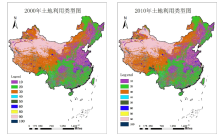
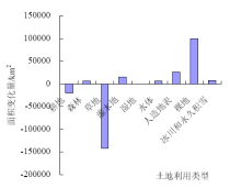
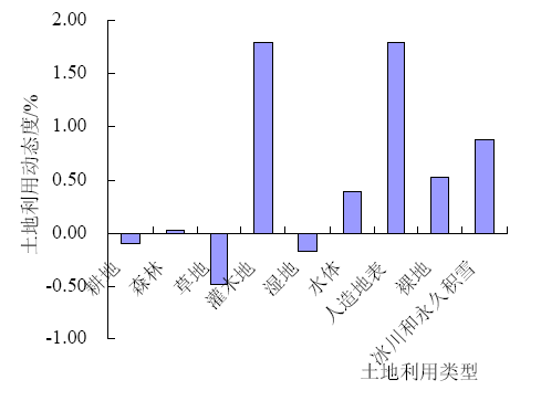
为了揭示21世纪初的10年,中国陆地区域土地利用格局的时空变化,基于全球30 m地表覆盖遥感数据产品(GlobeLand30),采用定性分析与定量分析相结合的方法,在中国陆地区域和流域尺度上,对10年间的土地利用转移矩阵与土地利用动态度进行实证研究。结果表明:研究区内土地利用类型主要以草地、森林和耕地为主,其中草地、耕地和湿地面积不断减少,分别减少了140413、20480、692 km 2,裸地和人造地表的面积增长的比较明显,增长了99645、26302 km 2;草地—裸地、草地—森林之间的转化较为剧烈,灌木地和人造地表的变化速率最大,达1.80%。各子流域内,土地利用类型时空格局变化不同,大部分流域以草地、耕地和森林为主。区域内草地、裸地和人造地表类型的变化明显,人为因素对土地利用格局的影响较大且活跃,自然因素的影响较为持久和稳定。
中图分类号:
胡悦琴, 马燕飞, 张伟科. 中国陆地区土地利用/覆被时空格局变化及驱动力分析[J]. 农学学报, 2020, 10(4): 26-35.
Hu Yueqin, Ma Yanfei, Zhang Weike. Land Use/Cover in China’s Land Areas: Spatio-temporal Pattern Change and Driving Forces Analysis[J]. Journal of Agriculture, 2020, 10(4): 26-35.

| 代码 | 类型 | 定义 |
|---|---|---|
| 10 | 耕地 | 用于种植农作物的土地,包括水田、灌溉旱地、雨养旱地、菜地、牧草种植地、大棚用地、 以种植农作物为主间有果树及其他经济乔木的土地,以及茶园、咖啡园等灌木类经济作物种植地 |
| 20 | 森林 | 乔木覆盖且树冠盖度超过30%的土地,包括落叶阔叶林、常绿阔叶林、落叶针叶林、常绿针叶林、混交林, 及树冠盖度为10%~30%的疏林地 |
| 30 | 草地 | 天然草本植被覆盖,且盖度大于10%的土地,包括草原、草甸、稀树草原、荒漠草原,以及城市人工草地等 |
| 40 | 灌木地 | 灌木覆盖且灌丛覆盖度高于30%的土地,包括山地灌丛、落叶和常绿灌丛,以及荒漠地区覆盖度高于10%的荒漠灌丛 |
| 50 | 湿地 | 位于陆地和水域的交界带,有浅层积水或土壤过湿的土地,多生长有沼生或湿生植物。 包括内陆沼泽、湖泊沼泽、河流洪泛湿地、森林/灌木湿地、泥炭沼泽、红树林、盐沼等 |
| 60 | 水体 | 陆地范围液态水覆盖的区域,包括江河、湖泊、水库、坑塘等 |
| 70 | 苔原 | 寒带环境下由地衣、苔藓、多年生耐寒草本和灌木植被覆盖的土地,包括灌丛苔原、禾本苔原、湿苔原、裸地苔原等 |
| 80 | 人造地表 | 由人工建造活动形成的地表,包括城镇等各类居民地、工矿、交通设施等,不包括建设用地内部连片绿地和水体 |
| 90 | 裸地 | 植被覆盖度低于10%的自然覆盖土地,包括荒漠、沙地、砾石地、裸岩、盐碱地等 |
| 100 | 冰川和永久积雪 | 由永久积雪、冰川和冰盖覆盖的土地,包括高山地区永久积雪、冰川,以及极地冰盖等 |
| 类型 | 2000年 | 2010年 | |||
|---|---|---|---|---|---|
| 面积/km2 | 比例/% | 面积/km2 | 比例/% | ||
| 耕地 | 2043388 | 21.54 | 2022908 | 21.33 | |
| 森林 | 2101943 | 22.16 | 2108822 | 22.23 | |
| 草地 | 2947856 | 31.08 | 2807443 | 29.60 | |
| 灌木地 | 84519 | 0.89 | 99760 | 1.05 | |
| 湿地 | 41733 | 0.44 | 41041 | 0.43 | |
| 水体 | 142978 | 1.51 | 148374 | 1.56 | |
| 人造地表 | 146033 | 1.54 | 172335 | 1.82 | |
| 裸地 | 1882154 | 19.84 | 1981799 | 20.89 | |
| 冰川和永久积雪 | 94046 | 0.99 | 102278 | 1.08 | |

| 耕地 | 森林 | 草地 | 灌木地 | 湿地 | 水体 | 人造地表 | 裸地 | 冰川和永久积雪 | |
|---|---|---|---|---|---|---|---|---|---|
| 耕地 | 1699266 | 140080 | 105058 | 5043 | 2090 | 18356 | 68770 | 4605 | 9 |
| 森林 | 140057 | 1771924 | 157559 | 17941 | 316 | 6337 | 3355 | 2480 | 1835 |
| 草地 | 103560 | 166135 | 2389301 | 40104 | 6087 | 10779 | 6169 | 206439 | 19193 |
| 灌木地 | 4500 | 16138 | 28784 | 28148 | 228 | 818 | 155 | 5409 | 335 |
| 湿地 | 2893 | 608 | 5863 | 190 | 26419 | 4034 | 149 | 1486 | 1 |
| 水体 | 17708 | 6162 | 9564 | 573 | 3756 | 100378 | 1991 | 2641 | 135 |
| 人造地表 | 47131 | 2584 | 3385 | 126 | 64 | 1205 | 91147 | 350 | 0 |
| 裸地 | 7644 | 2490 | 98646 | 7129 | 2014 | 6291 | 533 | 1748688 | 8716 |
| 冰川和永久积雪 | 10 | 2529 | 9203 | 490 | 0 | 67 | 0 | 9693 | 72054 |


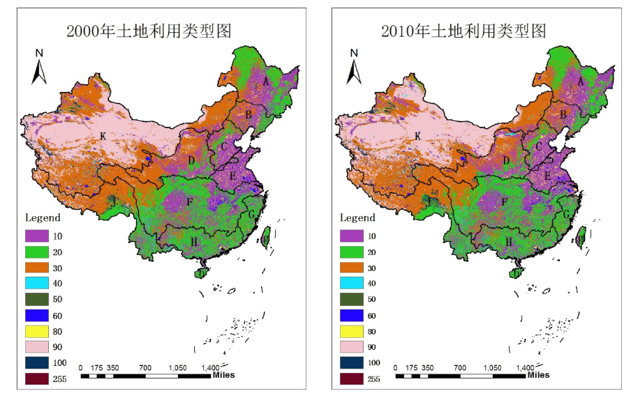
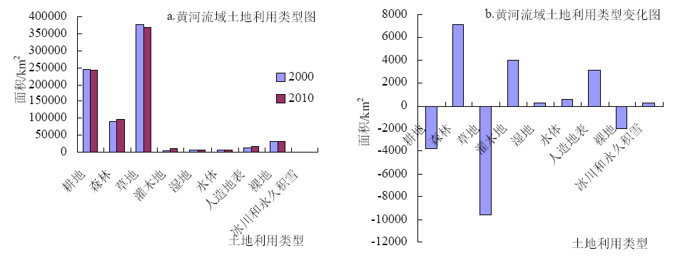
| 类型 | 年份 | 松花江区(A) | 辽河区(B) | 海河区(C) | 黄河区(D) | 淮河区(E) | 长江区(F) | 东南诸河(G) | 珠江区(H) | 西南诸河(J) | 西北诸河(K) |
|---|---|---|---|---|---|---|---|---|---|---|---|
| 耕地 | 2000年 | 301814 | 130992 | 176055 | 245425 | 247133 | 523988 | 58654 | 160043 | 59728 | 133393 |
| 2010年 | 299426 | 128875 | 171905 | 241669 | 242228 | 519751 | 56171 | 159940 | 61289 | 136267 | |
| 变化 | -2388 | -2117 | -4150 | -3756 | -4905 | -4237 | -2483 | -103 | 1561 | 2874 | |
| 森林 | 2000年 | 365282 | 58267 | 57395 | 91118 | 19084 | 758059 | 153296 | 341976 | 231092 | 20661 |
| 2010年 | 367049 | 56467 | 57890 | 98242 | 17718 | 760079 | 153549 | 339680 | 228859 | 23677 | |
| 变化 | 1767 | -1800 | 495 | 7124 | -1366 | 2020 | 253 | -2296 | -2233 | 3016 | |
| 草地 | 2000年 | 208423 | 96569 | 52034 | 379226 | 4261 | 383281 | 12310 | 51412 | 438738 | 1318387 |
| 2010年 | 208001 | 99471 | 51237 | 369612 | 5091 | 377554 | 12245 | 52899 | 421106 | 1206936 | |
| 变化 | -422 | 2902 | -797 | -9614 | 830 | -5727 | -65 | 1487 | -17632 | -111451 | |
| 灌木地 | 2000年 | 30 | 730 | 242 | 4366 | 0 | 21736 | 441 | 7973 | 19040 | 29753 |
| 2010年 | 30 | 716 | 631 | 8383 | 0 | 23812 | 456 | 7979 | 20362 | 37118 | |
| 变化 | 0 | -14 | 389 | 4017 | 0 | 2076 | 15 | 6 | 1322 | 7365 | |
| 湿地 | 2000年 | 13940 | 812 | 701 | 7379 | 1322 | 5160 | 208 | 249 | 372 | 10787 |
| 2010年 | 12997 | 894 | 792 | 7657 | 885 | 5155 | 115 | 154 | 384 | 11024 | |
| 变化 | -943 | 82 | 91 | 278 | -437 | -5 | -93 | -95 | 12 | 237 | |
| 水体 | 2000年 | 11904 | 2752 | 4208 | 5423 | 12251 | 38262 | 3408 | 10513 | 6117 | 44566 |
| 2010年 | 12044 | 2543 | 4439 | 5974 | 12630 | 36974 | 3509 | 10451 | 5865 | 50200 | |
| 变化 | 140 | -209 | 231 | 551 | 379 | -1288 | 101 | -62 | -252 | 5634 | |
| 人造地表 | 2000年 | 15088 | 11856 | 21350 | 13952 | 34830 | 22088 | 7322 | 10893 | 1207 | 6225 |
| 2010年 | 15749 | 12945 | 25090 | 17122 | 40327 | 28936 | 9628 | 11979 | 1498 | 7415 | |
| 变化 | 661 | 1089 | 3740 | 3170 | 5497 | 6848 | 2306 | 1086 | 291 | 1190 | |
| 裸地 | 2000年 | 8724 | 4536 | 157 | 32370 | 227 | 9997 | 149 | 46 | 78797 | 1745096 |
| 2010年 | 9905 | 4601 | 158 | 30409 | 210 | 10534 | 128 | 39 | 86021 | 1837658 | |
| 变化 | 1181 | 65 | 1 | -1961 | -17 | 537 | -21 | -7 | 7224 | 92562 | |
| 冰川和永久积雪 | 2000年 | 0 | 0 | 0 | 185 | 0 | 3060 | 0 | 0 | 38380 | 51421 |
| 2010年 | 0 | 0 | 0 | 376 | 0 | 2831 | 0 | 0 | 48087 | 50001 | |
| 变化 | 0 | 0 | 0 | 191 | 0 | -229 | 0 | 0 | 9707 | -1420 |


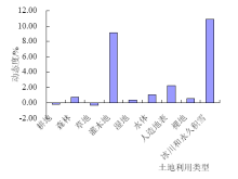
| 耕地 | 森林 | 草地 | 灌木地 | 湿地 | 水体 | 人造地表 | 裸地 | 冰川和永久积雪 | |
|---|---|---|---|---|---|---|---|---|---|
| 耕地 | 205166 | 7359 | 22404 | 546 | 330 | 1263 | 7836 | 468 | 0 |
| 森林 | 6070 | 76027 | 8205 | 200 | 21 | 78 | 129 | 53 | 0 |
| 草地 | 22996 | 13918 | 326627 | 5621 | 1751 | 955 | 763 | 6587 | 212 |
| 灌木地 | 399 | 359 | 1677 | 1764 | 8 | 7 | 7 | 156 | 0 |
| 湿地 | 439 | 37 | 1283 | 18 | 5192 | 360 | 17 | 40 | 0 |
| 水体 | 991 | 65 | 764 | 18 | 308 | 3200 | 55 | 18 | 0 |
| 人造地表 | 5092 | 95 | 404 | 21 | 6 | 31 | 8287 | 13 | 0 |
| 裸地 | 463 | 46 | 8491 | 196 | 46 | 76 | 31 | 23141 | 41 |
| 冰川和永久积雪 | 0 | 0 | 24 | 0 | 0 | 0 | 0 | 26 | 136 |

| [1] | 宋敏敏 . 黄土高原典型小流域土地利用格局变化研究[D]. 杨凌:西北农林科技大学, 2018. |
| [2] | 刘纪远, 邓祥征 . LUCC时空过程研究的方法进展[J]. 科学通报, 2009,54(21):3251-3258. |
| [3] | Brondizio S Eduardo, Moran Emilio F . Level-dependent deforestation trajectories in the Brazilian Amazon from 1970 to 2001[J]. Population and Environment, 2012,34(1):9-85. |
| [4] | Dang A N, Kawasaki A . Integrating biophysical and socio-economic factors for land-use and land-cover change projection in agricultural economic regions[J]. Ecological Modelling, 2017(344):29-37. |
| [5] | 李京京 . 黄土高原地区土地利用/覆被变化及其驱动力分析研究[D]. 杨凌:西北农林科技大学, 2017. |
| [6] | 刘纪远, 匡文慧, 张增祥 , 等. 20世纪80年代末以来中国土地利用变化的基本特征与空间格局[J]. 地理学报, 2014,69(1):3-14. |
| [7] | 张海燕, 樊江文, 邵全琴 . 2000—2010年中国退牧还草工程区土地利用/覆被变化[J]. 地理科学进展, 2015,34(7):840-853. |
| [8] | 朱恒峰, 赵文武, 康慕谊 , 等. 延河流域土地利用格局时空变化与驱动因子分析[J]. 干旱区资源与环境, 2008,22(8):17-22. |
| [9] | 汪雪格, 吕军, 刘伟 , 等. 松花江流域1950—2015年土地利用的分形动态研究[J]. 中国农学通报, 2017,33(24):57-61. |
| [10] | 胡琼, 吴文斌, 项铭涛 , 等. 全球耕地利用格局时空变化分析[J]. 中国农业科学, 2018,51(6):1091-1105. |
| [11] | 陈军, 廖安平, 陈晋 , 等. 全球30 m地表覆盖遥感数据产品-GlobeLand30[J]. 地理信息世界, 2017,24(1):1-8. |
| [12] | 朱会义, 李秀彬 . 关于区域土地利用变化指数模型方法的讨论[J]. 地理学报, 2003,58(5):643-650. |
| [13] | 李忠锋, 王彦丽 . 定边县土地利用动态变化研究[J]. 干旱区地理, 2004,27(4):520-524. |
| [14] | 郑国强, 江南, 史同广 . 长江三角洲土地利用变化及驱动力分析[J]. 南京林业大学学报:自然科学版, 2004,28(6):18-22. |
| [15] | 满苏尔·沙比提, 玉苏甫·买买提, 娜斯曼·那斯尔丁 . 1991—2011年新疆于田绿洲土地利用/覆被时空变化特征分析[J]. 冰川冻土, 2014,36(3):582-589. |
| [16] | 周秋文, 杨胜天, 罗娅 , 等. 2001—2009年中国及周边国家土地利用/覆被变化分析[J]. 世界地理研究, 2012,21(2):64-79. |
| [17] | 尹娟, 柳德江, 赵敏慧 , 等. 2000—2014年抚仙湖流域土地利用动态变化研究[J]. 中国农学通报, 2018,34(4):101-107. |
| [18] | 王光谦, 王思远, 陈志祥 . 黄河流域的土地利用和土地覆盖变化[J]. 清华大学学报:自然科学版, 2004. |
| [19] | 李芳芳 . 基于RS与GIS的枣阳市土地利用与覆被变化及驱动力研究[D]. 武汉:华中农业大学, 2012. |
| [20] | Serra P, Pons X, Sauri D . Land-cover and land- use change in a Mediterranean landscape: a spatial analysis of driving forces integrating biophysical and human factors[J]. Applied Geography, 2008(3):189-209. |
| [21] | 曹慧明, 许东 . 松花江流域土地利用格局时空变化分析[J]. 中国农学通报, 2014,30(8):144-149. |
| [22] | 郭洪峰, 许月卿, 吴艳芳 . 基于地形梯度的土地利用格局与时空变化分析——以北京市平谷区为例[J]. 经济地理, 2013,33(1):160-166,186. |
| [23] | 李浩 . 基于人均土地利用转移量的新疆土地利用变化及驱动力的空间分析[D]. 乌鲁木齐:新疆大学, 2017. |
| [24] | 李克让, 陈育峰, 黄玫 , 等. 气候变化对土地覆被变化的影响及其反馈模型[J]. 地理学报, 2000,55(11):57-63. |
| [25] | 刘吉羽 . 基于GlobeLand30的我国西北地区耕地变化及其驱动力分析[D]. 成都:西南交通大学, 2015. |
| [26] | 徐冬冬, 倪金星, 黄震方 , 等. 江苏省土地利用变化特征与驱动机制研究[J]. 南京师范大学学报:自然科学版, 2016(03):110-117. |
| [27] | 王靖淘 . 基于遥感与GIS的土地利用景观格局变化研究[D]. 陕西省:西安科技大学, 2018. |
| [28] | 李晨曦, 吴克宁, 刘霈珈 , 等. 土地利用变化及社会经济驱动因素——以京津冀地区为例[J]. 江苏农业科学, 2017,45(12):279-283. |
| [29] | 朱小立 . 区域土地利用/土地覆被变化及其人口驱动机制研究[D]. 开封:河南大学, 2006. |
| [30] | 杨玉婷 . 黑河中游土地利用动态变化及驱动力研究——以甘州区为例[D]. 兰州:西北师范大学, 2012. |
| [31] | 吴菲, 吴俊峰, 凌虹 , 等. 太湖流域土地利用变化研究[J]. 资源与环境, 2018,28(7):143-145. |
| [1] | 薛斯文, 解雪峰, 吴涛, 于红梅, 周旗. 杭州城市边缘区暴露度评价[J]. 农学学报, 2022, 12(5): 85-90. |
| [2] | 李斌, 杨豪中. 深度贫困山区精准扶贫的困境及对策研究——以商洛市商州区为例[J]. 农学学报, 2021, 11(9): 118-124. |
| [3] | 章秀梅, 杨文叶, 张丹, 谢国雄, 袁杭杰. 农地排水中水溶性重金属浓度及其与土壤性状的关系研究[J]. 农学学报, 2021, 11(8): 42-47. |
| [4] | 张童, 刘宇飞, 隋心, 宋福强. 土地利用方式对黑龙江西部地区土壤理化性质和酶活性的影响[J]. 农学学报, 2021, 11(5): 33-41. |
| [5] | 张勇, 李彦军, 杜轶. 黄土丘陵区丰水年产流产沙特征分析[J]. 农学学报, 2021, 11(5): 51-56. |
| [6] | 黄宝华. 基于遥感的山东省土地利用时空变化和驱动力分析[J]. 农学学报, 2021, 11(4): 62-67. |
| [7] | 王国玲,李艳红,苏志珠,李想,马义娟. 2008—2013年晋北地区土地利用/覆被变化研究[J]. 农学学报, 2019, 9(5): 38-43. |
| [8] | 刘学娅,赵亚洲,冷平生. 城市污泥的土地利用及其环境影响研究进展[J]. 农学学报, 2018, 8(6): 21-27. |
| [9] | 林宁,关学彬,麦全法. 三亚市10年间景观格局变化分析[J]. 农学学报, 2017, 7(2): 68-73. |
| [10] | 阮弋飞,邬奇峰,张丹,楼中,谢国雄. 临安市主要农地土壤酸化特征及其改良技术探讨[J]. 农学学报, 2016, 6(3): 21-26. |
| [11] | 刘瑞娜,杨太明,陈金华. 近50年安徽省油菜涝渍灾害时空变化分析[J]. 农学学报, 2016, 6(1): 110-116. |
| [12] | 谷秀兰,黄朝明,栾乔林,韦仕川. 基于多指标测度的土地利用结构分析——以海口市为例[J]. 农学学报, 2015, 5(7): 132-140. |
| [13] | 黄锦祥. 宁化县不同土地利用方式水土保持措施及效果探讨[J]. 农学学报, 2015, 5(5): 57-61. |
| [14] | 季淑枫,倪中应,许杰,裘希雅,江校尧,谢国雄. 杭州市耕地土壤有机质状况及时空变化特点[J]. 农学学报, 2015, 5(10): 56-59. |
| 阅读次数 | ||||||
|
全文 |
|
|||||
|
摘要 |
|
|||||