欢迎访问《农学学报》,

农学学报 ›› 2025, Vol. 15 ›› Issue (2): 33-42.doi: 10.11923/j.issn.2095-4050.cjas2024-0011

• 土壤肥料 资源环境 生态 • 上一篇    下一篇

基于GIS的湖北省农业用地适宜性评价

梁嘉毅(), 彭玉玲(), 陈知椿   

  1. 武汉工程大学土木工程与建筑学院,武汉 430074
  • 收稿日期:2024-01-15 修回日期:2024-04-25 出版日期:2025-02-20 发布日期:2025-02-18
  • 通讯作者:
    彭玉玲,女,1986年出生,汉族,河南洛阳人,博士,副教授,硕导,研究方向:国土空间规划与GIS空间优化。E-mail:
  • 作者简介:

    梁嘉毅,男,2003年出生,湖北武汉人,本科。通信地址:430074 湖北省武汉市雄楚大道693号 武汉工程大学土木工程与建筑学院,E-mail:

  • 基金资助:
    中华人民共和国住房和城乡建设部科学技术计划项目“基于GIS的城乡土地多尺度统筹规划方法研究”(2019-R-020)

GIS-based Suitability Evaluation of Agricultural Land in Hubei Province

LIANG Jiayi(), PENG Yuling(), CHEN Zhichun   

  1. School of Civil Engineering and Architecture of Wuhan Institute of Technology, Wuhan 430074
  • Received:2024-01-15 Revised:2024-04-25 Online:2025-02-20 Published:2025-02-18

摘要:

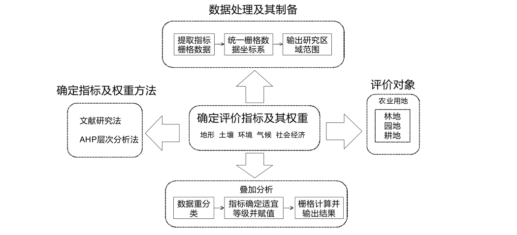
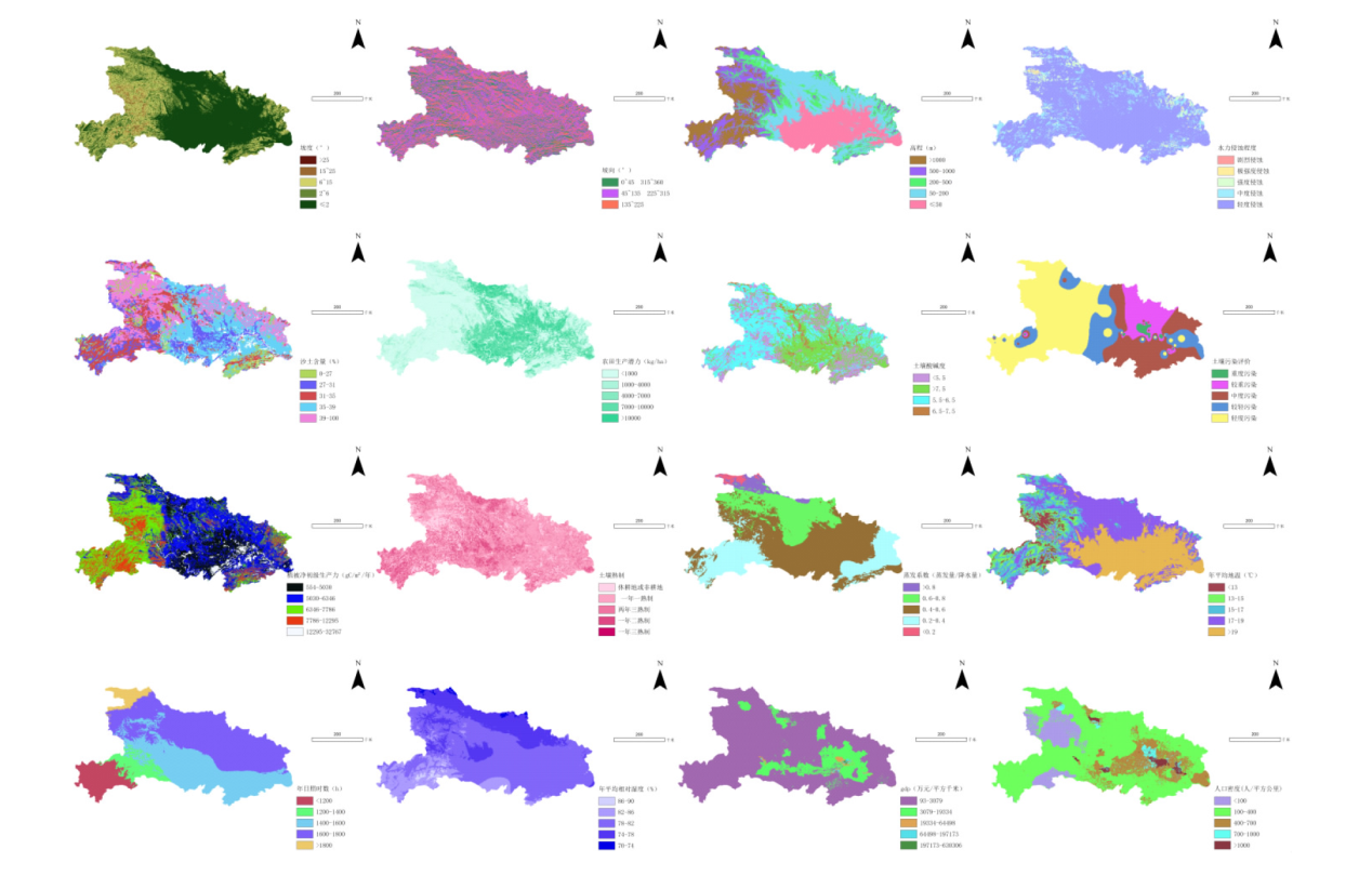
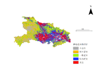
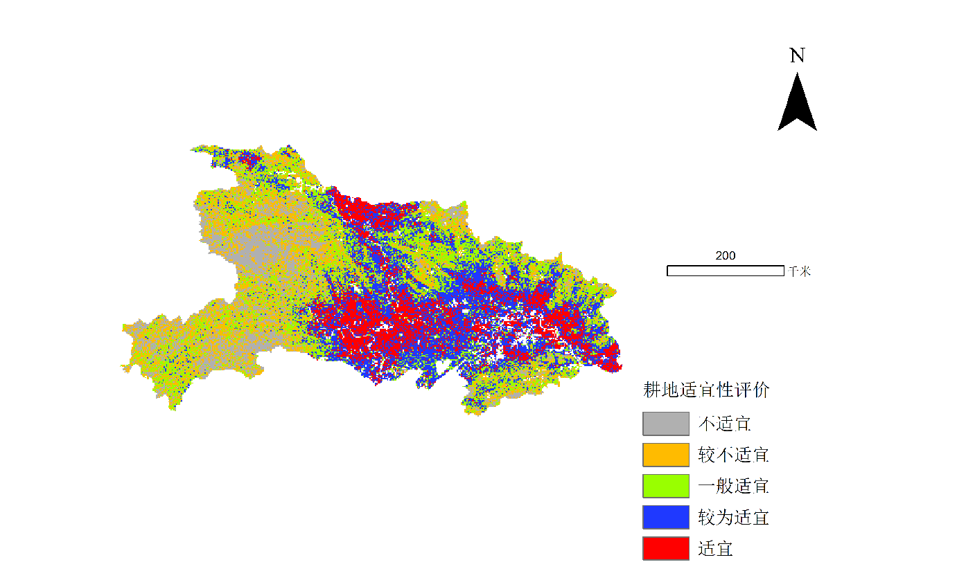
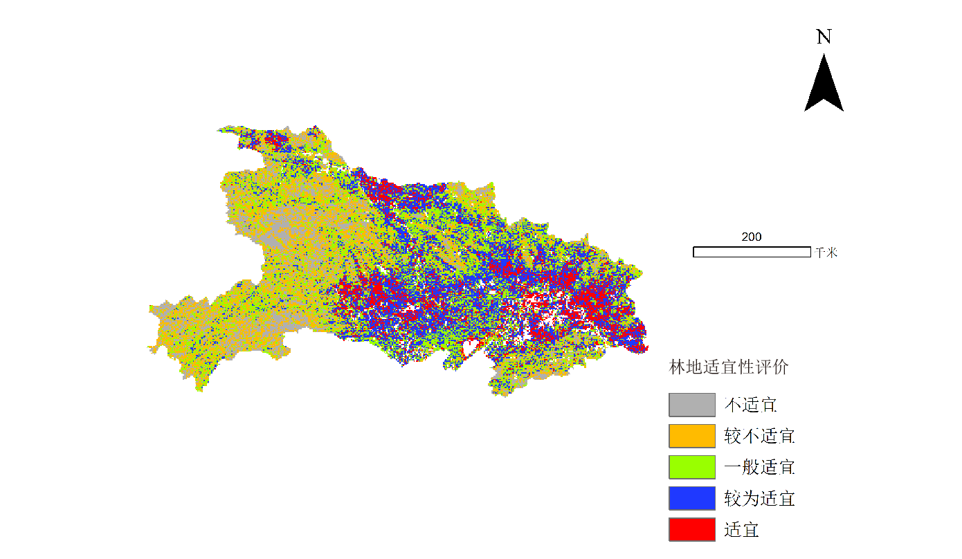
本研究旨在提升湖北省农业用地的总体利用效率,进行了适宜性分析和评价。选取地形、土壤、环境、气候、社会经济5个方面16个评价因子对于湖北省进行3种农业用地类型(耕地,林地,园地)的适宜性评价,以1 km栅格数据作为评价单元,结合运用AHP层次分析法和德尔菲法确定指标权重,划分出适宜、较为适宜、一般适宜、较不适宜、不适宜5种农业用地适宜性等级。结果表明:耕地、园地、林地的适宜区域分别为15.3%、11.6%、9.0%,且3种农业用地的比较适宜区和适宜区基本集中在江汉平原地带和湖北省北部地区,该区域光热充足,环境和土壤条件适宜,适宜区域被较为适宜区域包含在内,并且适宜性较高的区域主要集中在湖北省东部和南部,其次在北部,西部适宜度最低。以上结果可以为湖北省土地利用规划和农业用地开发提供参考。

关键词: 地理信息系统, 湖北省, 农业用地, 适宜性评价, AHP层次分析法, 土地利用规划

Abstract:

In order to improve the overall utilization efficiency of agricultural land in Hubei Province, the suitability of agricultural land in Hubei Province was analyzed and evaluated. 16 evaluation factors in five aspects, including topography, soil, environment, climate and social economy, were selected to evaluate the suitability of three types of agricultural land (cultivated land, forest land and orchard land) in Hubei Province. The 1km raster data was used as the evaluation unit, and the index weights were determined by AHP analytic hierarchy process and Delphi method, and five suitability grades of agricultural land were divided: suitable, relatively suitable, generally suitable, less suitable and unsuitable. The results showed that the suitable areas of cultivated land, orchard land and forest land were 15.3%, 11.6% and 9.0%, respectively, and the more suitable areas and suitable areas of the three types of agricultural land were basically concentrated in the Jianghan Plain and the north of Hubei Province, the area had sufficient light and heat, suitable environmental and soil conditions, suitable areas were included in the more suitable areas, and the areas with higher suitability were mainly concentrated in the east and south of Hubei Province, followed by the north and the west of Hubei Province. The above results can provide a reference for land use planning and agricultural land development in Hubei Province.

Key words: Arc gis, Hubei Province, agricultural land, suitability evaluation, AHP analytic hierarchy process, land use planning