欢迎访问《农学学报》,
农学学报 ›› 2024, Vol. 14 ›› Issue (1): 44-52.doi: 10.11923/j.issn.2095-4050.cjas2023-0168
邹恒宇1,2( ), 叶英聪1,2(), 匡丽花1,2
收稿日期:2023-07-25
修回日期:2023-09-15
出版日期:2024-01-16
发布日期:2024-01-16
通讯作者:
作者简介:邹恒宇,男,2001年出生,江西抚州人,硕士研究生,研究方向:土地资源管理。通信地址:330045 江西省南昌市经济技术开发区志敏大道1101号,E-mail:1677516825@qq.com。
基金资助:
ZOU Hengyu1,2(), YE Yingcong1,2(), KUANG Lihua1,2
Received:2023-07-25
Revised:2023-09-15
Online:2024-01-16
Published:2024-01-16
摘要:
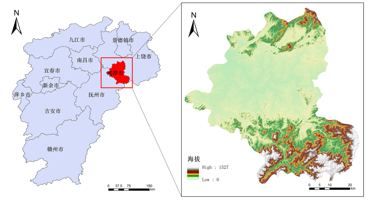
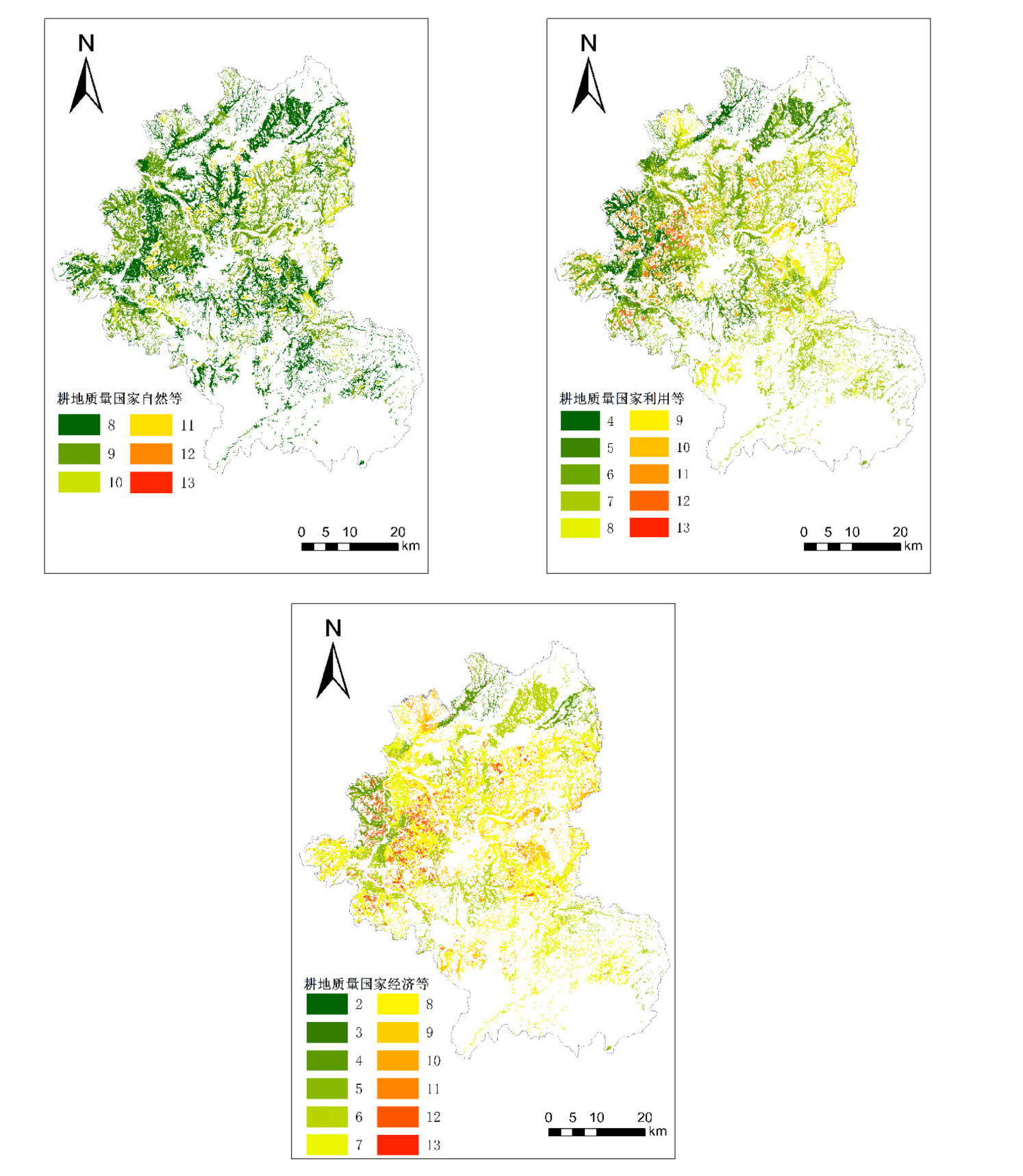
研究耕地质量与景观格局间的关系,可以为加强国家耕地质量保护和提升提供科学依据。利用江西省鹰潭市2022年耕地质量数据,在耕地质量评价的基础上综合分析鹰潭市的总体耕地质量状况。选取斑块面积、斑块占景观比例、边界密度、斑块密度、景观形状指数、平均斑块大小、景观分离度、蔓延度指数和香农多样性指数等景观格局指数在Fragstats 4.2软件中进行计算,再将耕地面积加权平均国家自然等别、利用等别、经济等别指数分别与选取的耕地景观格局指数进行相关性分析。研究得出,耕地质量国家自然等指数与耕地边界密度呈极显著负相关,相关系数为-0.393(P<0.01);耕地质量国家利用等指数与耕地平均斑块大小和香农多样性指数呈极显著正相关,相关系数分别为0.343(P<0.01)和0.416(P<0.01);耕地质量国家经济等指数与耕地边界密度呈极显著负相关,相关系数为-0.381(P<0.01)。因此部分景观格局指数与耕地质量之间存在明显的相关性,可以在一定程度上反映该区域内耕地质量与景观格局指数间的关联。研究结果可为从景观格局角度实现耕地质量的提升与保护工作提供科学参考,对国家层面做出优化区域耕地空间布局决策也具有一定的现实意义。
邹恒宇, 叶英聪, 匡丽花. 耕地质量与景观格局指数的关系研究——以江西省鹰潭市为例[J]. 农学学报, 2024, 14(1): 44-52.
ZOU Hengyu, YE Yingcong, KUANG Lihua. Study on the Relationship Between Cultivated Land Quality and Landscape Pattern Index--Taking Yingtan City of Jiangxi Province as An Example[J]. Journal of Agriculture, 2024, 14(1): 44-52.
| 耕地质量等别 | 等别 | 斑块面积/hm2 | 斑块占景观面积比例/% | PD/(个/km2) | ED/(m/hm2) | LSI | MPS/hm2 |
|---|---|---|---|---|---|---|---|
| 国家自然等 | 8 | 41379.43 | 47.77 | 42.96 | 306.31 | 41.89 | 2.33 |
| 9 | 38169.05 | 44.06 | 46.37 | 318.85 | 41.70 | 2.16 | |
| 10 | 3774.34 | 4.36 | 52.34 | 337.84 | 120.06 | 1.91 | |
| 11 | 3034.37 | 3.50 | 109.34 | 432.18 | 181.15 | 0.91 | |
| 12 | 246.34 | 0.28 | 166.37 | 539.22 | 876.68 | 0.60 | |
| 13 | 20.46 | 0.02 | 40.39 | 111.17 | 510.83 | 2.48 | |
| 平均值 | 14437.33 | 16.67 | 76.31 | 340.92 | 295.39 | 1.31 | |
| 国家利用等 | 4 | 5439.48 | 6.28 | 30.34 | 292.75 | 109.79 | 3.30 |
| 5 | 13467.34 | 15.55 | 39.16 | 281.84 | 59.83 | 2.55 | |
| 6 | 19643.85 | 22.68 | 40.23 | 292.94 | 57.70 | 2.49 | |
| 7 | 25109.42 | 28.99 | 39.37 | 327.59 | 57.89 | 2.54 | |
| 8 | 11634.94 | 13.43 | 51.39 | 329.60 | 80.16 | 1.95 | |
| 9 | 1320.38 | 1.52 | 95.59 | 411.55 | 281.74 | 1.05 | |
| 10 | 4762.69 | 5.50 | 94.17 | 415.19 | 182.13 | 1.06 | |
| 11 | 3437.19 | 3.97 | 95.67 | 413.41 | 170.08 | 1.05 | |
| 12 | 1795.22 | 2.07 | 49.28 | 328.61 | 165.91 | 2.03 | |
| 13 | 13.48 | 0.02 | 35.25 | 158.76 | 788.43 | 2.84 | |
| 平均值 | 8662.39 | 10.00 | 57.05 | 325.22 | 195.36 | 1.75 | |
| 国家经济等 | 3 | 304.66 | 0.35 | 22.49 | 351.78 | 534.03 | 4.45 |
| 4 | 3316.49 | 3.83 | 34.36 | 315.36 | 119.18 | 2.91 | |
| 5 | 4401.67 | 5.08 | 44.58 | 315.24 | 136.92 | 2.24 | |
| 6 | 16849.39 | 19.45 | 41.23 | 292.97 | 55.39 | 2.43 | |
| 7 | 28470.24 | 32.87 | 39.48 | 315.85 | 48.52 | 2.53 | |
| 8 | 18469.27 | 21.32 | 38.16 | 305.81 | 62.46 | 2.62 | |
| 9 | 4623.12 | 5.34 | 44.66 | 320.58 | 126.89 | 2.24 | |
| 10 | 2467.22 | 2.85 | 94.25 | 410.28 | 233.90 | 1.06 | |
| 11 | 3954.67 | 4.57 | 111.49 | 465.37 | 218.99 | 0.90 | |
| 12 | 3631.89 | 4.19 | 60.67 | 348.58 | 113.77 | 1.65 | |
| 13 | 135.37 | 0.16 | 3.46 | 24.99 | 51.71 | 28.90 | |
| 平均值 | 7874.91 | 9.09 | 48.62 | 315.17 | 154.70 | 2.06 |


| 耕地质量等别 | 描述性指标 | PD/(个/km2) | ED/(m/hm2) | LSI | MPS/hm2 | CONTAG/% | DIVISION | SHDI |
|---|---|---|---|---|---|---|---|---|
| 国家自然等 | 平均数 | 44.70 | 23.09 | 16.57 | 58.79 | 63.87 | 0.81 | 1.61 |
| 中位数 | 26.70 | 22.52 | 19.06 | 3.58 | 63.03 | 0.86 | 1.65 | |
| 标准差 | 64.25 | 14.80 | 7.38 | 423.72 | 14.62 | 0.18 | 0.72 | |
| 最大值 | 414.20 | 69.48 | 33.61 | 3393.69 | 87.86 | 0.93 | 2.87 | |
| 最小值 | 0.03 | 0.00 | 1.00 | 0.22 | 0.00 | 0.00 | 0.00 | |
| 国家利用等 | 平均数 | 45.52 | 24.54 | 17.05 | 3.63 | 62.80 | 0.84 | 1.75 |
| 中位数 | 27.13 | 23.08 | 19.18 | 3.69 | 67.27 | 0.92 | 1.82 | |
| 标准差 | 67.18 | 15.78 | 7.54 | 2.28 | 13.70 | 0.17 | 0.85 | |
| 最大值 | 467.41 | 78.41 | 37.92 | 11.43 | 99.15 | 1.05 | 3.62 | |
| 最小值 | 8.98 | 0.00 | 1.76 | 0.22 | 0.00 | 0.00 | 0.00 | |
| 国家经济等 | 平均数 | 45.48 | 24.53 | 16.90 | 31.08 | 62.62 | 0.83 | 1.76 |
| 中位数 | 25.81 | 21.94 | 17.99 | 3.45 | 63.17 | 0.87 | 1.72 | |
| 标准差 | 59.57 | 14.16 | 6.80 | 300.84 | 13.80 | 0.17 | 0.79 | |
| 最大值 | 414.22 | 69.45 | 33.61 | 3393.83 | 87.87 | 0.93 | 3.19 | |
| 最小值 | 0.03 | 0.00 | 1.00 | 0.22 | 0.00 | 0.00 | 0.00 |
| 指数 | PD | ED | LSI | MPS | CONTAG | DIVISION | SHDI |
|---|---|---|---|---|---|---|---|
| 面积加权平均国家自然等指数 | -0.009 | -0.393** | -0.067 | -0.032 | 0.005 | -0.116 | -0.003 |
| 面积加权平均国家利用等指数 | 0.207 | -0.173 | 0.023 | 0.343** | -0.183 | -0.003 | 0.416** |
| 面积加权平均国家经济等指数 | 0.113 | -0.381** | -0.016 | -0.139 | 0.097 | -0.005 | -0.117 |
| [1] |
项骁野, 王佑汉, 李谦, 等. 中国耕地保护与粮食安全研究进展可视化分析[J]. 中国农业资源与区划, 2022, 43(10):267-277.
|
| [2] |
刘利花, 张丙昕, 刘向华. 粮食安全与生态安全双视角下中国省域耕地保护补偿研究[J]. 农业工程学报, 2020, 36(19):252-263.
|
| [3] |
陈印军, 肖碧林, 方琳娜, 等. 中国耕地质量状况分析[J]. 中国农业科学, 2011, 44(17):3557-3564.
doi: doi: 10.3864/j.issn.0578-1752.2011.17.008 |
| [4] |
沈仁芳, 陈美军, 孔祥斌, 等. 耕地质量的概念和评价与管理对策[J]. 土壤学报, 2012, 49(6):1210-1217.
|
| [5] |
庞英, 张全景, 叶依广. 中国耕地资源利用效益研究[J]. 中国人口·资源与环境, 2004(5):34-38.
|
| [6] |
陈印军, 王晋臣, 肖碧林, 等. 我国耕地质量变化态势分析[J]. 中国农业资源与区划, 2011, 32(2):1-5.
|
| [7] |
陈文波, 肖笃宁, 李秀珍. 景观指数分类、应用及构建研究[J]. 应用生态学报, 2002(1):121-125.
|
| [8] |
邬建国. 景观生态学——概念与理论[J]. 生态学杂志, 2000(1):42-52.
|
| [9] |
|
| [10] |
|
| [11] |
宋戈, 刘燕妮, 张文琦, 等. 基于可改良限制因子的耕地质量等别提升潜力研究[J]. 农业工程学报, 2019, 35(14):261-269.
|
| [12] |
徐明岗, 卢昌艾, 张文菊, 等. 我国耕地质量状况与提升对策[J]. 中国农业资源与区划, 2016, 37(7):8-14.
|
| [13] |
关瑜, 陈影, 叶静, 等. 耕地质量多维评价与利用分区——以黄骅市为例[J]. 水土保持研究, 2022, 29(3):334-343,350.
|
| [14] |
张英, 冯雪珂, 任少宝, 等. 耕地质量和产能评价指标体系研究——以广西宾阳县为例[J]. 农业资源与环境学报, 2021, 38(6):1039-1050.
|
| [15] |
匡丽花, 叶英聪, 赵小敏, 等. 基于农用地分等修正的土地整治项目对耕地质量的影响评价[J]. 农业工程学报, 2016, 32(17):198-205.
|
| [16] |
李昊, 银敏华, 马彦麟, 等. 种植规模与细碎化对小农户耕地质量保护行为的影响——以蔬菜种植中农药、化肥施用为例[J]. 中国土地科学, 2022, 36(7):74-84
|
| [17] |
李博, 王瑞梅. 土地产权稳定性对农户耕地质量保护行为影响综述[J]. 资源科学, 2021, 43(5):909-920.
doi: 10.18402/resci.2021.05.05 |
| [18] |
吴璟, 昝梦莹, 王征兵. 感知价值对农户参与耕地质量保护意愿的影响——以陕西省为例[J]. 中国土地科学, 2020, 34(6):66-74.
|
| [19] |
|
| [20] |
|
| [21] |
张超, 高璐璐, 郧文聚, 等. 遥感技术获取耕地质量评价指标的研究进展分析[J]. 农业机械学报, 2022, 53(1):1-13.
|
| [22] |
王来刚, 郭燕, 贺佳, 等. 遥感数据辅助下县域耕地质量评价与空间分布研究[J]. 中国农业资源与区划, 2022, 43(12):137-146.
|
| [23] |
王丽, 周勇, 李晴, 等. 基于随机森林的耕地质量评价智能模型及其应用研究[J]. 土壤学报, 2022, 59(5):1279-1292.
|
| [24] |
刘彦文, 刘成武, 何宗宜, 等. 基于像元尺度耕地质量局部空间自相关的基本农田划定[J]. 农业机械学报, 2019, 50(5):260-268,319.
|
| [25] |
张晗, 赵小敏, 欧阳真程, 等. 基于空间自相关的耕地质量空间差异特征及耕地保护分区——以江西省上高县为例[J]. 水土保持研究, 2018, 25(1):304-312.
|
| [26] |
秦罗义, 白晓永, 王世杰, 等. 近40年来贵州普定典型喀斯特高原景观格局变化[J]. 生态学杂志, 2014, 33(12):3349-3357.
|
| [27] |
吴莉, 侯西勇, 徐新良, 等. 山东沿海地区土地利用和景观格局变化[J]. 农业工程学报, 2013, 29(5):207-216,293.
|
| [28] |
陈奕彤, 熊康宁, 肖时珍, 等. 中国丹霞赤水世界自然遗产景观格局时空演变及驱动因素分析[J]. 水土保持研究, 2018, 25(6):314-321.
|
| [29] |
李卫锋, 王仰麟, 彭建. 深圳市景观格局演变及其驱动因素分析[J]. 应用生态学报, 2004(8):1403-1410.
|
| [30] |
张月, 张飞, 周梅, 等. 干旱区内陆艾比湖区域景观生态风险评价及时空分异[J]. 应用生态学报, 2016, 27(1):233-242.
|
| [31] |
陈心怡, 谢跟踪, 张金萍. 海口市海岸带近30年土地利用变化的景观生态风险评价[J]. 生态学报, 2021, 41(3):975-986.
|
| [32] |
|
| [33] |
|
| [34] |
|
| [35] |
|
| [36] |
|
| [37] |
|
| [38] |
|
| [39] |
钱凤魁, 逄然然, 于洋, 等. 辽宁省不同地貌区耕地景观格局与耕地质量空间关联特征及作用机制[J]. 中国生态农业学报(中英文), 2023, 31(1):113-124.
|
| [40] |
沈立宏, 张超, 桑玲玲, 等. 利用网格法确定县域农田整治优先度[J]. 农业工程学报, 2012, 28(18):241-247,296.
|
| [41] |
韩逸, 郭熙, 江叶枫, 等. 南方丘陵区耕地质量与景观格局指数相关性分析[J]. 江苏农业学报, 2018, 34(5):1057-1065.
|
| [42] |
郭莎莎, 胡守庚, 瞿诗进. 长江中游地区多尺度耕地景观格局演变特征[J]. 长江流域资源与环境, 2018, 27(7):1637-1646.
|
| [43] |
游士兵, 严研. 逐步回归分析法及其应用[J]. 统计与决策, 2017(14):31-35.
|
| [44] |
刘立祥. 线性回归模型中自变量的选择与逐步回归方法[J]. 统计与决策, 2015(21):80-82.
|
| [45] |
李秀珍, 布仁仓, 常禹, 等. 景观格局指标对不同景观格局的反应[J]. 生态学报, 2004(1):123-134.
|
| [46] |
布仁仓, 胡远满, 常禹, 等. 景观指数之间的相关分析[J]. 生态学报, 2005(10):2764-2775.
|
| [47] |
陈利顶, 刘洋, 吕一河, 等. 景观生态学中的格局分析:现状、困境与未来[J]. 生态学报, 2008(11):5521-5531.
|
| [48] |
黄晓玉, 王兰会. SPSS 24.0统计分析[M]. 北京: 中国人民大学出版社, 2021:238.
|
| [49] |
陈帷胜, 冯秀丽, 马仁锋, 等. 耕地破碎度评价方法与实证研究——以浙江省宁波市为例[J]. 中国土地科学, 2016, 30(5):80-87.
|
| [50] |
李春雨, 加鹏华, 王树涛, 等. 阜平县不同海拔梯度下耕地土壤养分现状与分布特征[J]. 水土保持研究, 2022, 29(1):197-204.
|
| [51] |
孙晓兵, 孔祥斌, 温良友, 等. 华北集约化农区耕地细碎化特征及其整治模式研究——以河北曲周为例[J]. 农业现代化研究, 2019, 40(4):556-564.
|
| [52] |
李鑫, 欧名豪, 肖长江, 等. 基于景观指数的细碎化对耕地生产效率影响研究[J]. 长江流域资源与环境, 2012, 21(6):707-713.
|
| [53] |
陈茜, 何真, 方鹤楠, 等. 耕地景观破碎化同区域粮食产量变化的相关性探析[J]. 湖北农业科学, 2023, 62(3):1-7.
|
| [54] |
曹丽萍, 罗志军, 冉凤维, 等. 基于耕地质量和空间集聚格局的县域基本农田划定[J]. 水土保持研究, 2018, 25(4):349-355+364.
|
| [55] |
陈彦光. 基于Moran统计量的空间自相关理论发展和方法改进[J]. 地理研究, 2009, 28(6):1449-1463.
|
| [56] |
郭龙, 张海涛, 陈家赢, 等. 基于协同克里格插值和地理加权回归模型的土壤属性空间预测比较[J]. 土壤学报, 2012, 49(5):1037-1042.
|
| [1] | 柴乖强, 马曙皓阳, 李琳, 段义忠, 霍彦波, 亢福仁. 陕北风沙草滩区沙地蛋白桑最优氮、磷、钾配比的筛选[J]. 农学学报, 2023, 13(5): 35-43. |
| [2] | 田甜, 韩宇, 付山. “乡村振兴”视角下人力资本投资对农业发展影响的实证研究[J]. 农学学报, 2022, 12(4): 96-100. |
| [3] | 夏利娟, 蔡鲲鹏, 马莉娟, 陈文强, 王宇, 丁晨露, 冉强, 蔡健. 小麦品质相关分析和聚类分析[J]. 农学学报, 2021, 11(8): 1-7. |
| [4] | 张童, 刘宇飞, 隋心, 宋福强. 土地利用方式对黑龙江西部地区土壤理化性质和酶活性的影响[J]. 农学学报, 2021, 11(5): 33-41. |
| [5] | 郭佳君, 李茜. 基于耕地质量及农作物比较优势的种植业布局优化——以山西省武乡县为例[J]. 农学学报, 2021, 11(11): 118-124. |
| [6] | 彭荣南, 陈冰, 陈观浩, 何泽华, 邱世善, 宋祖钦, 梁盛铭. 水稻白叶枯病发生流行与气象条件关系及预测模型研究[J]. 农学学报, 2020, 10(2): 29-33. |
| [7] | 闫希光,张海娥. 应用IAD值确定‘徐香’猕猴桃后熟过程中的内在品质[J]. 农学学报, 2019, 9(7): 48-52. |
| [8] | 高海燕,程庆军,田承华,高鹏,张俊珍. 高粱净光合速率的遗传分析[J]. 农学学报, 2019, 9(1): 11-15. |
| [9] | 买合甫拉提?乃比,玉苏甫?买买提. 渭-库河绿洲种棉土壤pH与微量元素的相关性分析[J]. 农学学报, 2017, 7(6): 21-26. |
| [10] | 汤雷,石英尧. 从中籼区试结果看安徽省水稻发展趋势[J]. 农学学报, 2015, 5(2): 137-140. |
| 阅读次数 | ||||||
|
全文 |
|
|||||
|
摘要 |
|
|||||