Welcome to Journal of Agriculture,
Journal of Agriculture ›› 2025, Vol. 15 ›› Issue (2): 33-42.doi: 10.11923/j.issn.2095-4050.cjas2024-0011
Previous Articles Next Articles
LIANG Jiayi( ), PENG Yuling(), CHEN Zhichun
Received:2024-01-15
Revised:2024-04-25
Online:2025-02-20
Published:2025-02-18
LIANG Jiayi, PENG Yuling, CHEN Zhichun. GIS-based Suitability Evaluation of Agricultural Land in Hubei Province[J]. Journal of Agriculture, 2025, 15(2): 33-42.
Add to citation manager EndNote|Ris|BibTeX
URL: http://nxxb.caass.org.cn/EN/10.11923/j.issn.2095-4050.cjas2024-0011

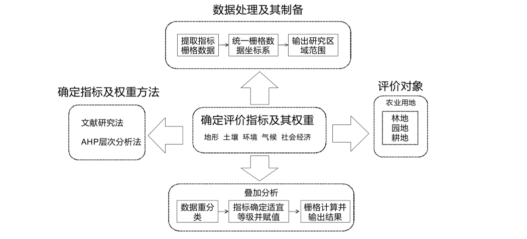
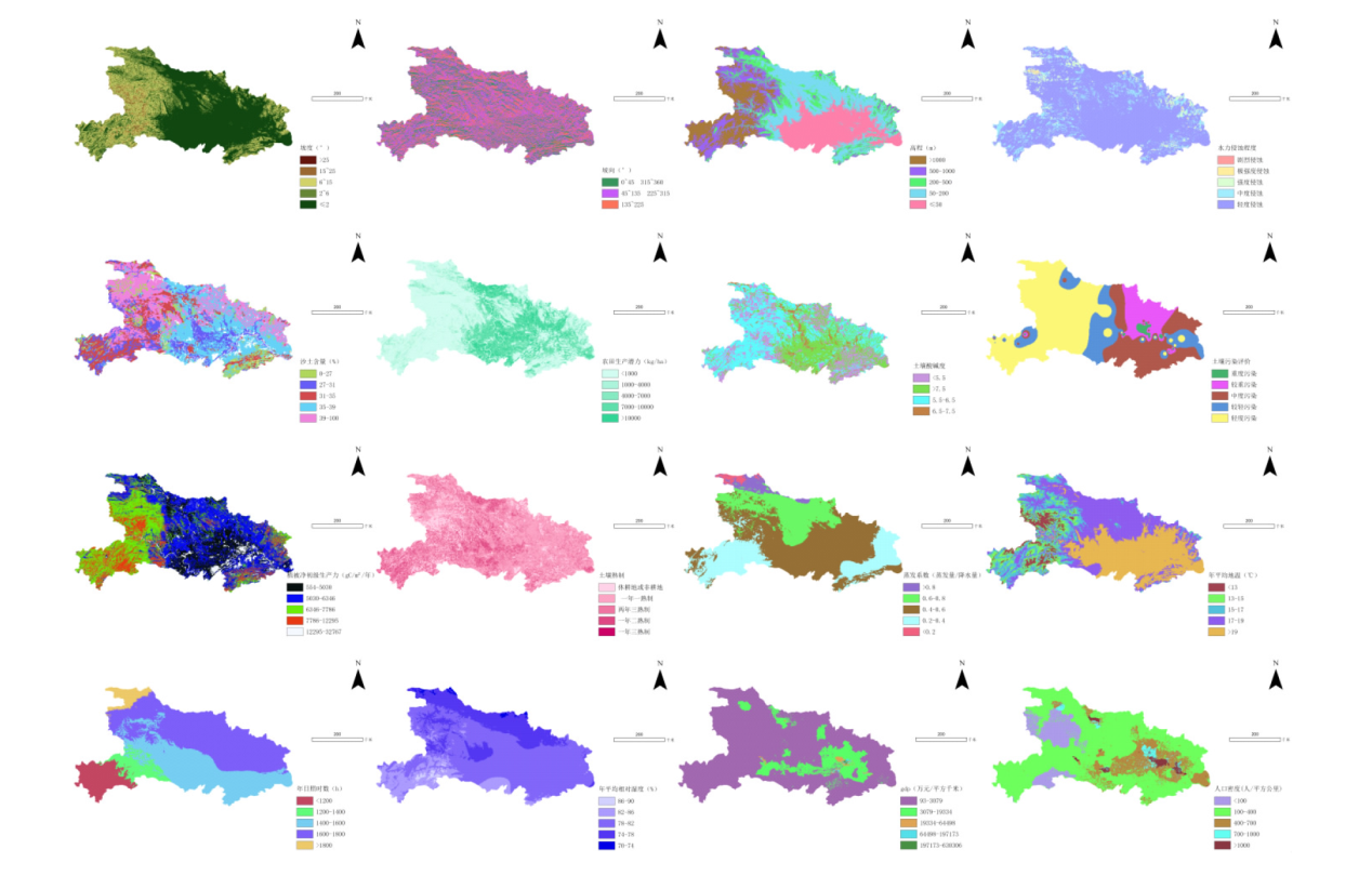
| 系统层 | 要素层 | 指标层 | 指标描述 |
|---|---|---|---|
| 农业用地 适宜性 | 地形因子 | 高程 | 反映研究区域地形状况 |
| 坡度 | |||
| 坡向 | |||
| 土壤因子 | 水力侵蚀程度 | 反映土壤被侵蚀的严重程度 | |
| 土壤质地 | 反映土壤质地特性 | ||
| 农田生产潜力 | 反映潜在的耕地生产价值 | ||
| 土壤酸碱度 | 反映土壤酸碱度对农业影响 | ||
| 环境因子 | 土壤污染物 | 反映土壤污染严重程度 | |
| NPP数值 | 反映作物生长固碳的环境条件 | ||
| 土壤熟制 | 反映农作物成熟条件 | ||
| 气候因子 | 蒸发系数 | 反映气候条件对农业的影响 | |
| 年平均地温 | |||
| 农业用地 适宜性 | 气候因子 | 年日照时数 | 反映气候条件对农业的影响 |
| 平均相对湿度 | |||
| 社会 经济因子 | GDP | 反应人类活动对农业的影响 | |
| 人口密度 |
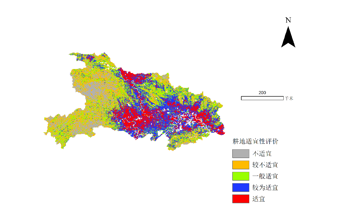
| 评价因子 | 适宜性等级 | |||||||
|---|---|---|---|---|---|---|---|---|
| 要素层 | 指标层 | 适宜 | 较为适宜 | 一般适宜 | 较不适宜 | 不适宜 | ||
| 地形因子 | 高程 | ≤50 | 50~200 | 200~500 | 500~1000 | >1000 | ||
| 坡度 | ≤2° | 2°~6° | 6°~15° | 15°~25° | >25 | |||
| 坡向 | …… | 135~225 | 45~135和225~315 | 0~45和315~360 | ||||
| 土壤因子 | 水力侵蚀程度 | 轻度侵蚀 | 中度侵蚀 | 强度侵蚀 | 极强度侵蚀 | 剧烈侵蚀 | ||
| 土壤质地(silt含量占比) | 39~100 | 35~39 | 31~35 | 27~31 | 0~27 | |||
| 农田生产潜力/(kg/hm2) | >10000 | 7000~10000 | 4000~7000 | 1000~4000 | <1000 | |||
| 土壤PH | 6.5~7.5 | 5.5~6.5 | >7.5 | <5.5 | …… | |||
| 环境因子 | 土壤污染物含量 | 3~2.92 | 2.84~2.92 | 2.77~2.84 | 2.70~2.77 | 2.21~2.70 | ||
| NPP/(g/m²) | 12295~32767 | 7786~12295 | 6346~7786 | 5030~6346 | 554~5030 | |||
| 土壤熟制 | 一年三熟制 | 一年二熟制 | 两年三熟制 | 一年一熟制 | 休耕地或非耕地 | |||
| 气候因子 | 蒸发系数:蒸发量/降水量 | <0.2 | 0.2~0.4 | 0.4~0.6 | 0.6~0.8 | >0.8 | ||
| 年平均地温/℃ | >19 | 17~19 | 15~17 | 13~15 | <13 | |||
| 年日照时数/h | >1800 | 1600~1800 | 1400~1600 | 1200~1400 | <1200 | |||
| 平均相对湿度/% | 74~70 | 78~74 | 82~78 | 86~82 | 90~86 | |||
| 社会经济因子 | GDP/(万元/km2) | 197173~630306 | 64498~197173 | 19334~64498 | 3079~19334 | 93~3079 | ||
| 人口密度/(人/km2) | >1000 | 1000~700 | 700~400 | 400~100 | <100 | |||
| 要素层 | 要素层权重 | 指标层 | 耕地权重 | 林地权重 | 园地权重 |
|---|---|---|---|---|---|
| 地形 因子 | 0.25 | 高程 | 0.36 | 0.34 | 0.27 |
| 坡度 | 0.3 | 0.36 | 0.31 | ||
| 坡向 | 0.34 | 0.3 | 0.42 | ||
| 土壤 因子 | 0.2 | 水力侵蚀程度 | 0.4 | 0.3 | 0.2 |
| 土壤质地 | 0.16 | 0.26 | 0.36 | ||
| 农田生产潜力 | 0.3 | 0.2 | 0.3 | ||
| 土壤酸碱度 | 0.14 | 0.24 | 0.14 | ||
| 环境 因子 | 0.25 | 土壤污染物 | 0.3 | 0.4 | 0.2 |
| NPP数值 | 0.1 | 0.5 | 0.5 | ||
| 土壤熟制 | 0.6 | 0.1 | 0.3 | ||
| 气候 因子 | 0.2 | 蒸发系数 | 0.4 | 0.4 | 0.4 |
| 年平均地温 | 0.2 | 0.2 | 0.2 | ||
| 年日照时数 | 0.2 | 0.2 | 0.2 | ||
| 平均相对湿度 | 0.2 | 0.2 | 0.2 | ||
| 社会经济因子 | 0.1 | GDP | 0.33 | 0.33 | 0.2 |
| 人口密度 | 0.67 | 0.67 | 0.8 |


| [1] |
|
| [2] |
|
| [3] |
徐梦洁, 梅艳, 宋奇海. 国内基于GIS的土地评价研究进展[J]. 土壤, 2007, 39(4):503-508.
|
| [4] |
柯新利, 荣庚午, 韩冰华. 基于AHP和GIS的湖北省耕地适宜性评价[J]. 国土与自然资源研究, 2011(4):35-38.
|
| [5] |
陈露露, 杜泳, 颉洪涛. 基于GIS的浙江省诸暨市农业用地适宜性分析与评价[J]. 中国农学通报, 2023, 39(21):158-164.
doi: 10.11924/j.issn.1000-6850.casb2022-0629 |
| [6] |
黄淑娟, 孟祥冰. 基于GIS技术的湖北省石首市生态适宜性评价[J]. 智能建筑与智慧城市, 2021(7):34-35.
|
| [7] |
湖北省国土资源厅. 湖北省土地利用总体规划(2006—2020年)[EB/OL]. https://zrzyt.hubei.gov.cn/fbjd/xxgkml/cxgh/201202/t20120201_1581375.shtml. 2012-02-01.
|
| [8] |
左军. 层次分析法中判断矩阵的间接给出法[J]. 系统工程, 1988(6):56-63.
|
| [9] |
江晓龙. 基于GIS的永安市农业用地适宜性评价[J]. 安徽农业科学, 2019, 47(17):58-60.
|
| [10] |
阿茹罕. 国土空间规划资源环境承载力评价研究[D]. 呼和浩特: 内蒙古师范大学, 2023.
|
| [11] |
中华人民共和国生态环境部. GB15618-2018,土壤环境质量农用地土壤污染管控风险标准(试行)[S]. 北京: 中国标准出版社, 2018.
|
| [12] |
冯彬, 张小强, 王志康, 等. 基于MODIS的典型区域生态功能区环境质量变化研究[J]. 安徽农业科学, 2020, 48(2):85-92.
|
| [13] |
|
| Viewed | ||||||
|
Full text |
|
|||||
|
Abstract |
|
|||||