欢迎访问《农学学报》,
农学学报 ›› 2024, Vol. 14 ›› Issue (7): 24-35.doi: 10.11923/j.issn.2095-4050.cjas2023-0137
郑铭宇( ), 蔡立群()
收稿日期:2023-05-30
修回日期:2023-08-17
出版日期:2024-07-20
发布日期:2024-07-10
通讯作者:
作者简介:郑铭宇,女,1999年出生,河北承德人,在读硕士研究生,研究方向:土壤资源评价及可持续利用。通信地址:730070 甘肃省兰州市安宁区甘肃农业大学,E-mail:208136988@qq.com。
基金资助:
ZHENG Mingyu(), CAI Liqun()
Received:2023-05-30
Revised:2023-08-17
Online:2024-07-20
Published:2024-07-10
摘要:
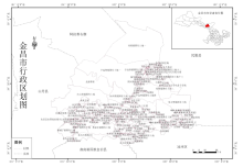
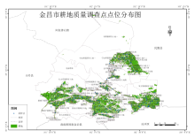
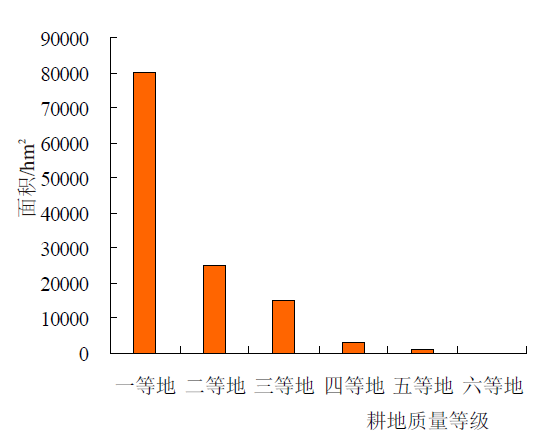
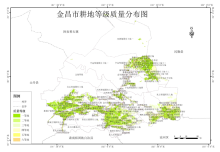
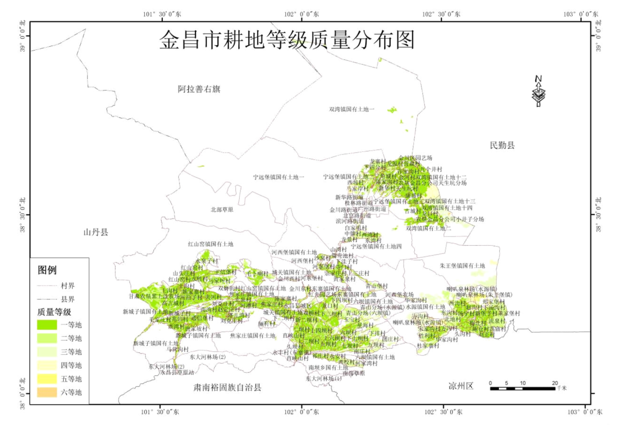
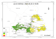
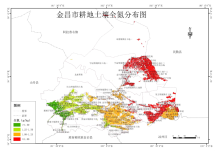
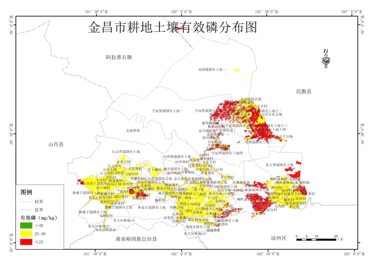
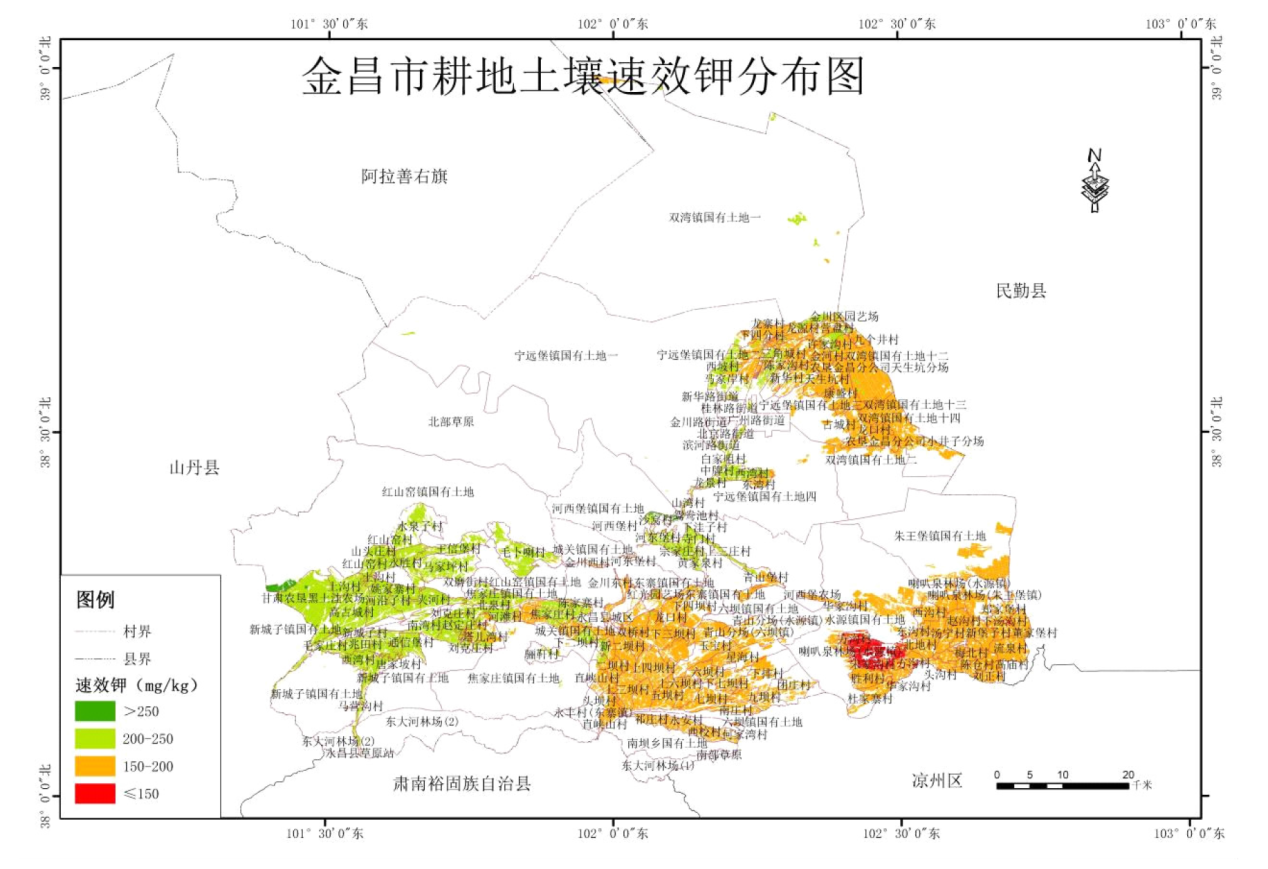
本研究以金昌市为研究区,通过对市域范围内耕地质量等级、土壤养分特征和空间分异的分析,在保障精度的条件下,为耕地的科学施肥和提高土壤养分区域化管理水平提供依据。模糊数学作为一种对模糊现象进行定量分析的方法,在许多领域都有广泛的应用价值。基于地理信息系统技术,阐述了该方法如何对耕地质量进行评价。本研究以金昌市为例,以《耕地质量等级》国家标准为依据,采用县域耕地资源管理信息系统和GIS技术相结合的方法,对该地区耕地质量等级与养分含量的空间分布进行了分析与研究。结果表明:金昌市耕地质量等级处于一至六等地,无七至十等地,一等地为金昌市耕地主体,面积为80024.40 hm2,占金昌市总耕地的64.35%;金昌市耕地养分整体水平较为中等,土壤有机质含量多属中低等水平,总体呈现西高东低趋势;全氮含量多属低等水平,总体呈现西南高东北低的趋势;有效磷含量多属较高水平,总体呈现西南地区高于东北地区;速效钾含量多属中低等水平,总体呈现西高东低趋势。金昌市耕地质量总体状况较好,可以通过增施有机肥,提高土壤肥力,加大灌溉力度、加大节水技术推广力度,使土壤保水保肥。
郑铭宇, 蔡立群. 基于模糊数学方法的金昌市耕地质量评价及土壤养分空间特征分析[J]. 农学学报, 2024, 14(7): 24-35.
ZHENG Mingyu, CAI Liqun. Cultivated Land Quality Evaluation and Soil Nutrient Spatial Characteristics Analysis Based on Fuzzy Mathematics Method in Jinchang City[J]. Journal of Agriculture, 2024, 14(7): 24-35.


| 各指标 | 测定方法 | 方法来源 |
|---|---|---|
| pH | 土壤检测第2部分:土壤pH的测定 | NY/T1121.2—2006 |
| 有机质 | 土壤检测第6部分:土壤有机质的测定 | NY/T1121.6—2006 |
| 全氮 | 土壤检测第24部分:土壤全氮的测定自动定氮仪法 | NY/T1121.24—2012 |
| 有效磷 | 土壤检测第7部分:土壤有效磷的测定 | NY/T1121.7—2014 |
| 速效钾 | 土壤速效钾和缓效钾含量的测定 | NY/T889—2004 |
| 各指标 | 测定方法 | 方法来源 |
|---|---|---|
| pH | 土壤检测第2部分:土壤pH的测定 | NY/T1121.2—2006 |
| 有机质 | 土壤检测第6部分:土壤有机质的测定 | NY/T1121.6—2006 |
| 全氮 | 土壤检测第24部分:土壤全氮的测定自动定氮仪法 | NY/T1121.24—2012 |
| 有效磷 | 土壤检测第7部分:土壤有效磷的测定 | NY/T1121.7—2014 |
| 速效钾 | 土壤速效钾和缓效钾含量的测定 | NY/T889—2004 |
| 质量评价 | 立地条件 | 剖面性状 | 理化性状 | 土壤养分 | 健康状况 | 土壤管理 | Wi |
|---|---|---|---|---|---|---|---|
| 立地条件 | 1.0000 | 1.0370 | 1.0980 | 1.1667 | 3.5000 | 1.0769 | 0.2022 |
| 剖面性状 | 0.9643 | 1.0000 | 1.0588 | 1.1250 | 3.3750 | 1.0385 | 0.1949 |
| 理化性状 | 0.9107 | 0.9444 | 1.0000 | 1.0625 | 3.1875 | 0.9808 | 0.1841 |
| 土壤养分 | 0.8571 | 0.8889 | 0.9412 | 1.0000 | 3.0000 | 0.9231 | 0.1733 |
| 健康状况 | 0.2857 | 0.2963 | 0.3137 | 0.3333 | 1.0000 | 0.3077 | 0.0578 |
| 土壤管理 | 0.9286 | 0.9630 | 1.0196 | 1.0833 | 3.2500 | 1.0000 | 0.1877 |
| 剖面性状 | 有效土层厚 | 质地构型 | 地下水埋深 | 障碍因素 | Wi |
|---|---|---|---|---|---|
| 有效土层厚 | 1.0000 | 0.8095 | 1.2143 | 0.8644 | 0.2372 |
| 质地构型 | 1.2353 | 1.0000 | 1.5000 | 1.0678 | 0.2930 |
| 地下水埋深 | 0.8235 | 0.6667 | 1.0000 | 0.7119 | 0.1953 |
| 障碍因素 | 1.1569 | 0.9365 | 1.4048 | 1.0000 | 0.2744 |
| 剖面性状 | 有效土层厚 | 质地构型 | 地下水埋深 | 障碍因素 | Wi |
|---|---|---|---|---|---|
| 有效土层厚 | 1.0000 | 0.8095 | 1.2143 | 0.8644 | 0.2372 |
| 质地构型 | 1.2353 | 1.0000 | 1.5000 | 1.0678 | 0.2930 |
| 地下水埋深 | 0.8235 | 0.6667 | 1.0000 | 0.7119 | 0.1953 |
| 障碍因素 | 1.1569 | 0.9365 | 1.4048 | 1.0000 | 0.2744 |
| 指标名称 | 指标权重 | 指标名称 | 指标权重 |
|---|---|---|---|
| 地下水埋深 | 0.0381 | 生物多样性 | 0.0305 |
| 地形部位 | 0.1493 | 速效钾 | 0.0393 |
| 耕层质地 | 0.0728 | 土壤容重 | 0.0364 |
| 灌溉能力 | 0.1207 | 盐渍化程度 | 0.075 |
| 农田林网化 | 0.0528 | 有机质 | 0.0715 |
| 排水能力 | 0.067 | 有效磷 | 0.0625 |
| 清洁程度 | 0.0272 | 有效土层厚 | 0.0462 |
| 质地构型 | 0.0571 | 障碍因素 | 0.0535 |
| 指标 | 隶属度 |
|---|---|
| 耕层质地 | 砂土(0.4)、黏土(0.5)、砂壤(0.7)、重壤(0.8)、轻壤(0.9)、中壤(1) |
| 质地构型 | 薄层型(0.4)、松散型(0.4)、上紧下松型(0.5)、夹层型(0.6)、紧实型(0.7)、海绵型(0.9)、上松下紧型(1) |
| 地形部位 | 山地坡上(0.4)、丘陵上部(0.5)、山地坡中(0.6)、丘陵中部(0.7)、山地坡下(0.75)、平原高阶(0.75)、 山间盆地(0.8)、丘陵下部(0.85)、宽谷盆地(0.85)、平原中阶(0.9)、平原低阶(1) |
| 生物多样性 | 不丰富(0.6)、一般(0.85)、丰富(1) |
| 农田林网化 | 低(0.7)、中(0.85)、高(1) |
| 清洁程度 | 尚清洁(0.85)、清洁(1) |
| 障碍因素 | 沙化(0.5)、盐碱(0.6)、渍潜(0.65)、障碍层次(0.65)、瘠薄(0.7)、无(1) |
| 灌溉能力 | 不满足(0.4)、基本满足(0.6)、满足(0.8)、充分满足(1) |
| 排水能力 | 不满足(0.4)、基本满足(0.6)、满足(0.8)、充分满足(1) |
| 盐渍化程度 | 盐土(0.3)、重度(0.4)、中度(0.75)、轻度(0.9)、无(1) |
| 指标 | 函数类型 | 函数公式 | a | c | U1 | U2 |
|---|---|---|---|---|---|---|
| 地下水埋深 | 戒上型 | y=1/(1+a*(u-c)^2) | 0.000293 | 56.275087 | 0.1 | 50 |
| 有效土层厚 | 戒上型 | y=1/(1+a*(u-c)^2) | 0.000089 | 149.661697 | 10 | 145 |
| 有机质 | 戒上型 | y=1/(1+a*(u-c)^2) | 0.001245 | 39.976682 | 2 | 39 |
| 有效磷 | 戒上型 | y=1/(1+a*(u-c)^2) | 0.001293 | 41.023703 | 2 | 40 |
| 速效钾 | 戒上型 | y=1/(1+a*(u-c)^2) | 0.000021 | 315.812898 | 20 | 315 |
| 土壤容重 | 峰型 | y=1/(1+a*(u-c)^2) | 6.390020 | 1.3104880 | 0.5 | 2 |
| 耕地质量等级 | 综合指数范围 | 耕地质量等级 | 综合指数范围 |
|---|---|---|---|
| 一等地 | ≥0.8401 | 六等地 | 0.7221~0.7461 |
| 二等地 | 0.8181~0.8401 | 七等地 | 0.6981~0.7221 |
| 三等地 | 0.7941~0.8181 | 八等地 | 0.6741~0.6981 |
| 四等地 | 0.7701~0.7941 | 九等地 | 0.6500~0.6741 |
| 五等地 | 0.7461~0.7701 | 十等地 | <0.6500 |
| 耕地质量等级 | 综合指数范围 | 耕地质量等级 | 综合指数范围 |
|---|---|---|---|
| 一等地 | ≥0.8401 | 六等地 | 0.7221~0.7461 |
| 二等地 | 0.8181~0.8401 | 七等地 | 0.6981~0.7221 |
| 三等地 | 0.7941~0.8181 | 八等地 | 0.6741~0.6981 |
| 四等地 | 0.7701~0.7941 | 九等地 | 0.6500~0.6741 |
| 五等地 | 0.7461~0.7701 | 十等地 | <0.6500 |
| 分级 | 有机质/(g/kg) | 全氮/(g/kg) | 有效磷/(mg/kg) | 速效钾/(mg/kg) |
|---|---|---|---|---|
| 一级(高) | >40 | >2.00 | >40 | >300 |
| 二级(较高) | 30~40 | 1.50~2.00 | 25~40 | 250~300 |
| 三级(中) | 20~30 | 1.25~1.5 | 15~25 | 200~250 |
| 四级(较低) | 10~20 | 1~1.25 | 6~15 | 150~200 |
| 五级(低) | ≤10 | ≤1 | ≤6 | ≤150 |
| 分级 | 有机质/(g/kg) | 全氮/(g/kg) | 有效磷/(mg/kg) | 速效钾/(mg/kg) |
|---|---|---|---|---|
| 一级(高) | >40 | >2.00 | >40 | >300 |
| 二级(较高) | 30~40 | 1.50~2.00 | 25~40 | 250~300 |
| 三级(中) | 20~30 | 1.25~1.5 | 15~25 | 200~250 |
| 四级(较低) | 10~20 | 1~1.25 | 6~15 | 150~200 |
| 五级(低) | ≤10 | ≤1 | ≤6 | ≤150 |

| 乡镇名称 | 面积及比例 | 一等地 | 二等地 | 三等地 | 四等地 | 五等地 | 六等地 |
|---|---|---|---|---|---|---|---|
| 城关镇 | 面积/hm2 | 2506.69 | 422.08 | 17.77 | — | — | — |
| 比例/% | 3.13 | 1.69 | 0.12 | — | — | — | |
| 东寨镇 | 面积/hm2 | 11572.00 | 2885.85 | — | — | — | — |
| 比例/% | 14.46 | 11.58 | — | — | — | — | |
| 广州路街道 | 面积/hm2 | — | — | 26.99 | — | — | — |
| 比例/% | — | — | 0.18 | — | — | — | |
| 桂林路街道 | 面积/hm2 | 5.65 | — | — | — | — | — |
| 比例/% | 0.01 | — | — | — | — | — | |
| 河西堡镇 | 面积/hm2 | 2086.94 | 912.44 | 425.78 | 6.36 | — | — |
| 比例/% | 2.61 | 3.66 | 2.82 | 0.21 | — | — | |
| 红山窑镇 | 面积/hm2 | 17574.47 | 3249.74 | 32.32 | — | — | — |
| 比例/% | 21.96 | 13.04 | 0.21 | — | — | — | |
| 焦家庄镇 | 面积/hm2 | 4584.19 | 76.54 | 12.97 | — | — | — |
| 比例/% | 5.73 | 0.31 | 0.09 | — | — | — | |
| 金川路街道 | 面积/hm2 | 2.33 | — | — | 1.18 | — | — |
| 比例/% | 0.00 | — | — | 0.04 | — | — | |
| 六坝镇 | 面积/hm2 | 5455.21 | 4472.65 | 1639.66 | — | — | — |
| 比例/% | 6.82 | 17.94 | 10.88 | — | — | — | |
| 南坝乡 | 面积/hm2 | 635.75 | 1174.01 | — | — | — | — |
| 比例/% | 0.79 | 4.71 | — | — | — | — | |
| 南部草原 | 面积/hm2 | 4.54 | — | — | — | — | — |
| 比例/% | 0.01 | — | — | — | — | — | |
| 宁远堡镇 | 面积/hm2 | 3168.57 | 3092.33 | 661.67 | 173.24 | 142.69 | 30.43 |
| 比例/% | 3.96 | 12.41 | 4.39 | 5.78 | 11.33 | 40.02 | |
| 双湾镇 | 面积/hm2 | 15468.58 | 923.14 | 3741.45 | 1438.15 | — | 45.60 |
| 比例/% | 19.33 | 3.70 | 24.82 | 48.01 | — | 59.98 | |
| 水源镇 | 面积/hm2 | 3186.33 | 3681.14 | 5418.03 | 646.73 | 345.60 | — |
| 比例/% | 3.98 | 14.77 | 35.94 | 21.59 | 27.43 | — | |
| 新城子镇 | 面积/hm2 | 8659.93 | 35.97 | 551.40 | — | — | — |
| 比例/% | 10.82 | 0.14 | 3.66 | — | — | — | |
| 新华路街道 | 面积/hm2 | — | — | — | 9.79 | 0.59 | — |
| 比例/% | — | — | — | 0.33 | 0.05 | — | |
| 朱王堡镇 | 面积/hm2 | 5113.23 | 3999.29 | 2548.34 | 719.92 | 770.92 | — |
| 比例/% | 6.39 | 16.05 | 16.90 | 24.03 | 61.19 | — |
| 养分名称 | 含量占比 | 养分等级 | ||||
|---|---|---|---|---|---|---|
| 一级(高) | 二级(较高) | 三级(中) | 四级(较低) | 五级(低) | ||
| 有机质 | 含量/(g/kg) | >40 | 30~40 | 20~30 | 10~20 | ≤10 |
| 占样品数量/% | — | 3.13 | 36.88 | 53.13 | 6.88 | |
| 全氮 | 含量/(g/kg) | >2.00 | 1.50~2.00 | 1.25~1.50 | 1.00~1.25 | ≤1.00 |
| 占样品数量/% | — | 11.88 | 20.63 | 35.63 | 31.88 | |
| 有效磷 | 含量/(g/kg) | >40 | 25~40 | 15~25 | 6~15 | ≤6 |
| 占样品数量/% | 36.25 | 35.63 | 21.88 | 6.25 | — | |
| 速效钾 | 含量/(g/kg) | >300 | 250~300 | 200~250 | 150~200 | ≤150 |
| 占样品数量/% | 21.25 | 10.63 | 20.63 | 26.88 | 20.63 | |
| 乡镇名称/养分名称 | 有机质/(g/kg) | 全氮/(g/kg) | 有效磷/(mg/kg) | 速效钾/(mg/kg) | |||||||
|---|---|---|---|---|---|---|---|---|---|---|---|
| 平均值 | 等级 | 平均值 | 等级 | 平均值 | 等级 | 平均值 | 等级 | ||||
| 城关镇 | 22.53 | 中等 | 1.23 | 较低 | 34.47 | 较高 | 195.92 | 较低 | |||
| 东寨镇 | 21.67 | 中等 | 1.18 | 较低 | 33.22 | 较高 | 187.05 | 较低 | |||
| 广州路街道 | 16.27 | 较低 | 0.75 | 低 | 24.36 | 中等 | 207.53 | 中等 | |||
| 桂林路街道 | 15.89 | 较低 | 0.72 | 低 | 24.93 | 中等 | 212.20 | 中等 | |||
| 河西堡镇 | 22.28 | 中等 | 1.08 | 较低 | 30.30 | 较高 | 225.01 | 中等 | |||
| 红山窑镇 | 23.03 | 中等 | 1.38 | 中等 | 30.19 | 较高 | 220.14 | 中等 | |||
| 焦家庄镇 | 23.08 | 中等 | 1.31 | 中等 | 31.91 | 较高 | 202.24 | 中等 | |||
| 金川路街道 | 17.45 | 较低 | 0.84 | 低 | 25.26 | 较高 | 208.25 | 中等 | |||
| 六坝镇 | 19.26 | 较低 | 1.09 | 较低 | 27.84 | 较高 | 171.30 | 较低 | |||
| 南坝乡 | 21.43 | 中等 | 1.23 | 较低 | 31.25 | 较高 | 178.16 | 较低 | |||
| 南部草原 | 25.98 | 中等 | 1.79 | 较高 | 27.58 | 较高 | 228.77 | 中等 | |||
| 宁远堡镇 | 17.11 | 较低 | 0.77 | 低 | 23.88 | 中等 | 204.16 | 中等 | |||
| 双湾镇 | 14.33 | 较低 | 0.68 | 低 | 24.47 | 中等 | 188.93 | 较低 | |||
| 水源镇 | 16.73 | 较低 | 0.90 | 低 | 25.08 | 较高 | 160.69 | 较低 | |||
| 新城子镇 | 25.79 | 中等 | 1.49 | 中等 | 28.80 | 较高 | 227.41 | 中等 | |||
| 新华路街道 | 16.77 | 较低 | 0.78 | 低 | 24.43 | 中等 | 210.21 | 中等 | |||
| 朱王堡镇 | 17.24 | 较低 | 1.01 | 较低 | 26.74 | 较高 | 165.85 | 较低 | |||


| [1] |
程锋, 王洪波, 郧文聚. 中国耕地质量等级调查与评定[J]. 中国土地科学, 2014, 28(2):75-82,97.
|
| [2] |
刘婷. 基于多功能竞争力评价的耕地主导功能类型识别研究[D]. 广州: 华南农业大学, 2018.
|
| [3] |
辛芸娜, 范树印, 孔祥斌, 等. 四重质量维度下的县域耕地质量评价方法研究[J]. 资源科学, 2018, 40(4):737-747.
doi: 10.18402/resci.2018.04.08 |
| [4] |
王策. 基于可持续发展需求的山区耕地产能评价研究[D]. 保定: 河北农业大学, 2020.
|
| [5] |
孙聪康, 徐俊丽, 余敦, 等. 多尺度下崇义县耕地质量空间分布差异特征研究[J]. 中国生态农业学报(中英文), 2019, 27(4):601-612.
|
| [6] |
叶细养, 汤建东. 广东耕地地力调查与质量评价试点工作的成果及其应用展望[J]. 生态环境, 2003(2):248-249.
|
| [7] |
张超, 乔敏, 郧文聚, 等. 耕地数量、质量、生态三位一体综合监管体系研究[J]. 农业机械学报, 2017, 48(1):1-6.
|
| [8] |
陈方正, 任健, 刘思涵, 等. 基于最小数据集的洞庭湖流域南部耕地土壤肥力综合评价[J]. 土壤通报, 2021, 52(6):1348-1359.
|
| [9] |
江文娟, 汤萌萌, 汪甜甜, 等. 宣城市耕地质量等级及土壤养分空间分布特征[J]. 土壤通报, 2022, 53(1):36-44.
|
| [10] |
赵艳玲, 赵彬程, 王鑫, 等. 基于地形分区IDW的复垦排土场土壤养分空间分布[J]. 煤田地质与勘探, 2020, 48(4):199-205.
|
| [11] |
谭海燕, 童江云, 包涛, 等. 昆明市滇池片区耕地土壤养分含量空间分布及变化情况分析[J]. 西南农业学报, 2019, 32(7):1614-1620.
|
| [12] |
|
| [13] |
|
| [14] |
|
| [15] |
马倩倩, 董博, 许旺旺, 等. 干旱区耕地质量等级评价及土壤养分与盐渍化的分析研究——以民勤绿洲为例[J]. 干旱区地理, 2021, 44(2):514-524.
|
| [16] |
谭思佳, 蔡立群. 基于GIS的金塔县耕地质量等级评价及特征分析[J]. 国土与自然资源研究, 2022(5):27-31.
|
| [17] |
张宇鹏, 吴笑天, 李希来, 等. 黄河源流域单元退化高寒草甸空间分布及其对土壤理化性质的响应[J]. 草地学报, 2022, 30(3):503-512.
doi: 10.11733/j.issn.1007-0435.2022.03.001 |
| [18] |
张梦莹, 蔡立群. 玉门市耕地质量等级及其养分空间分布研究[J]. 国土与自然资源研究, 2021(4):1-5.
|
| [19] |
任先鹏, 李彦, 程春国, 等. 高标准农田建设项目区耕地质量等级评价研究——以肇东市明久乡为例[J]. 现代农业科技, 2022(24):203-207.
|
| [20] |
洪惠煌, 温从雨. 基于GIS的绩溪县耕地地力评价[J]. 中国农技推广, 2013, 29(3):43-45.
|
| [21] |
陈向婧, 谢会萍, 张素素, 等. 农业循环经济中耕地质量等级模糊综合评价模型[J]. 高师理科学刊, 2017, 37(6):21-25.
|
| [22] |
郁洁, 高晖, 李文西, 等. 基于GIS的江苏省耕地质量等级评价[J]. 中国土壤与肥料, 2022(3):222-230.
|
| [23] |
桂彩虹, 郑梦蕾, 丁世伟, 等. 桐城市耕地主要养分变化分析[J]. 现代农业科技, 2021(11):187-189+195.
|
| [24] |
姚冬辉, 吴建富, 卢志红, 等. 江西省耕地土壤pH值和养分状况调查[J]. 湖南农业大学学报(自然科学版), 2020, 46(5):574-579.
|
| [25] |
木合塔尔·艾买提, 肖鹏南, 周勇, 等. 山地丘陵交错地带耕层土壤pH和养分空间变异特征及影响因素分析[J]. 南方农业学报, 2019, 50(7):1432-1441.
|
| [26] |
段友春. 基于GIS的鲁东南典型丘陵平原区农田土壤养分空间变异特征及影响因素研究[J]. 中国农学通报, 2021, 37(23):61-68.
doi: 10.11924/j.issn.1000-6850.casb2020-0853 |
| [27] |
李秀彬. 中国近20年来耕地面积的变化及其政策启示[J]. 自然资源学报, 1999(4):329-333.
|
| [28] |
张美兰. 基于GIS的耕地地力评价研究[D]. 兰州: 兰州大学, 2010.
|
| [29] |
崔增团, 郭世乾. 基于GIS的河西走廊灌溉农业区耕地地力评价研究——以甘肃省肃州区耕地地力评价为例[J]. 中国农业资源与区划, 2012, 33(1):56-61.
|
| [1] | 刘雅杰, 刘战勇, 张向前, 路战远, 迟文峰, 程玉臣, 张德健, 孙峰, 刘祾悦, 兰慧青, 白东星. 大兴安岭南麓黑土区阿荣旗耕地质量评价与障碍因素分析[J]. 农学学报, 2024, 14(7): 58-66. |
| [2] | 韩家宝, 董瑜, 农尚健, 金家全, 冯永洪, 张雁, 高秋美, 张艳艳, 李恺, 高斯源, 张国洪, 李晓婷. 陆良植烟土壤养分丰缺状况与时空变异特征分析[J]. 农学学报, 2024, 14(4): 58-65. |
| [3] | 杨楠茜, 刘宪斌, 赵星硕, 董晗. 生境对紫茎泽兰叶片外部形态结构的影响[J]. 农学学报, 2023, 13(9): 46-53. |
| [4] | 潘义宏, 蔡宪杰, 邓涛, 左伟标, 李晓婷, 徐继超, 冯永洪, 保华, 闫鼎. 多栽培因素与土壤养分对‘云烟105’含梗率影响关联分析[J]. 农学学报, 2023, 13(9): 31-37. |
| [5] | 姜生秀, 赵鹏, 朱淑娟. 不同种植方式对油莎豆幼苗生长及产量的影响[J]. 农学学报, 2023, 13(7): 32-37. |
| [6] | 田晶华, 郭凤鸣, 陈克龙, 廖萍, 杨云. 红塔区花卉耕层土壤有机质含量与其他养分相关性研究[J]. 农学学报, 2023, 13(11): 43-48. |
| [7] | 崔彦芹, 李思达, 徐桂真, 侯少锋, 关中波, 郭元章. 芝麻连作土壤养分含量和酶活性的变化及其对芝麻发芽的影响[J]. 农学学报, 2023, 13(1): 21-25. |
| [8] | 赵跃, 黄楠, 刘继培. 生物有机肥配施硅钙钾镁肥对西瓜产量、品质及土壤养分的影响[J]. 农学学报, 2022, 12(9): 37-41. |
| [9] | 毛伟, 李文西, 赵雨涵, 陈明, 徐迅燕, 王长松, 王娟娟, 钱晓晴. 有机肥替代部分化肥对水稻产量及土壤理化性质的影响[J]. 农学学报, 2021, 11(8): 32-36. |
| [10] | 张莉, 徐运飞, 尹健, 谷彩花, 赵敏, 李欢欢, 王婧, 任斌. 种植方式对文冠果幼苗生长及土壤理化性质的影响[J]. 农学学报, 2021, 11(12): 64-67. |
| [11] | 杜倩, 王冰, 李冰, 王昌全, 谢云波, 陈玉蓝. 凉山州植烟土壤养分与烟叶化学品质的相关性分析[J]. 农学学报, 2021, 11(11): 54-60. |
| [12] | 王琪珍, 范永强, 徐风霞. 莱芜生姜温度适宜性研究[J]. 农学学报, 2020, 10(9): 38-42. |
| [13] | 王安, 孙剑霞, 常庆涛, 谢吉先, 吴薇. 不同有机肥用量对芋头生长、食味品质和土壤肥力的影响[J]. 农学学报, 2020, 10(8): 42-46. |
| [14] | 曾洪玉,李志勇,唐宝国,姚开文,毛 伟. 不同磷肥用量对油菜产量、肥料利用率及土壤养分的影响[J]. 农学学报, 2019, 9(7): 31-36. |
| [15] | 龙文靖,倪先林,刘天朋,丁国祥,赵甘霖. 国家高粱原原种扩繁基地土壤养分和酶的垂直分布特性[J]. 农学学报, 2019, 9(5): 33-37. |
| 阅读次数 | ||||||
|
全文 |
|
|||||
|
摘要 |
|
|||||