欢迎访问《农学学报》,

农学学报 ›› 2026, Vol. 16 ›› Issue (4): 79-87.doi: 10.11923/j.issn.2095-4050.cjas2025-0198

• 农业信息 农业气象 • 上一篇    下一篇

子午岭植被覆盖变化规律及其气候敏感性分析

张雪姣1(), 张天峰2, 王娟2, 李美瑜3, 南莹莹1   

  1. 1 甘肃省合水县气象局, 甘肃合水 745400
    2 甘肃省庆阳市气象局, 甘肃庆阳 745000
    3 甘肃省正宁县气象局, 甘肃正宁 745300
  • 收稿日期:2025-11-28 修回日期:2026-02-12 出版日期:2026-04-15 发布日期:2026-04-15
  • 作者简介:

    张雪姣,女,1990年出生,宁夏隆德人,高级工程师,硕士,研究方向:气象服务。通信地址:745400 甘肃省合水县气象局,E-mail:

  • 基金资助:
    甘肃省气象局“飞天风云”青年基层人才项目“子午岭植被覆盖变化规律及其气候敏感性分析”(2425rczx-C-QNJCRC-09)

Change Law of Vegetation Cover in Ziwuling Region and Its Climatic Sensitivity Analysis

ZHANG Xuejiao1(), ZHANG Tianfeng2, WANG Juan2, LI Meiyu3, NAN Yingying1   

  1. 1 Meteorological Bureau of Heshui County, Gansu Province, Heshui, Gansu 745400
    2 Meteorological Bureau of Qingyang City, Gansu Province, Qingyang, Gansu 745000
    3 Meteorological Bureau of Zhengning County, Gansu Province, Zhengning, Gansu 745300
  • Received:2025-11-28 Revised:2026-02-12 Online:2026-04-15 Published:2026-04-15

摘要:

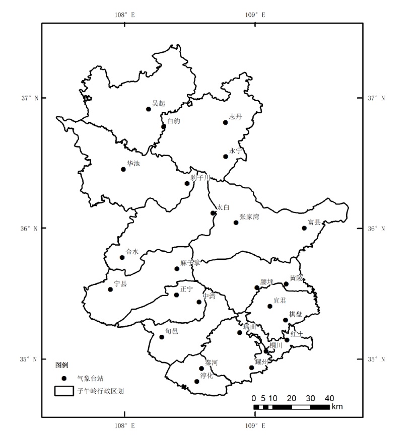
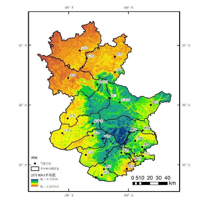
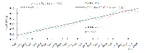
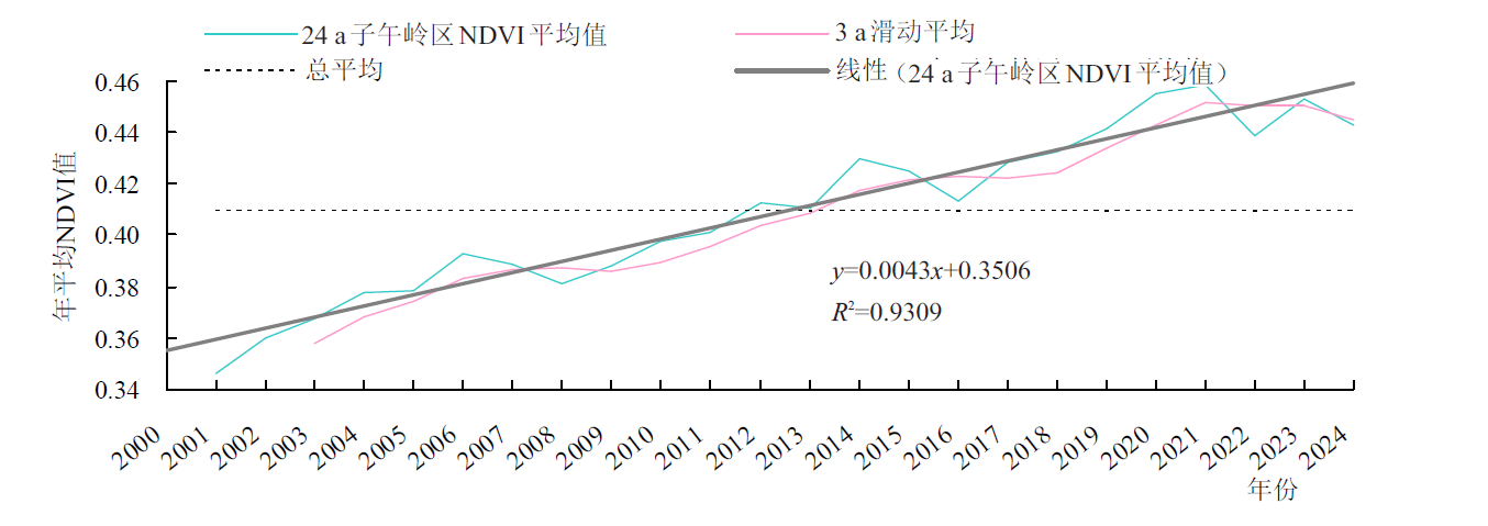
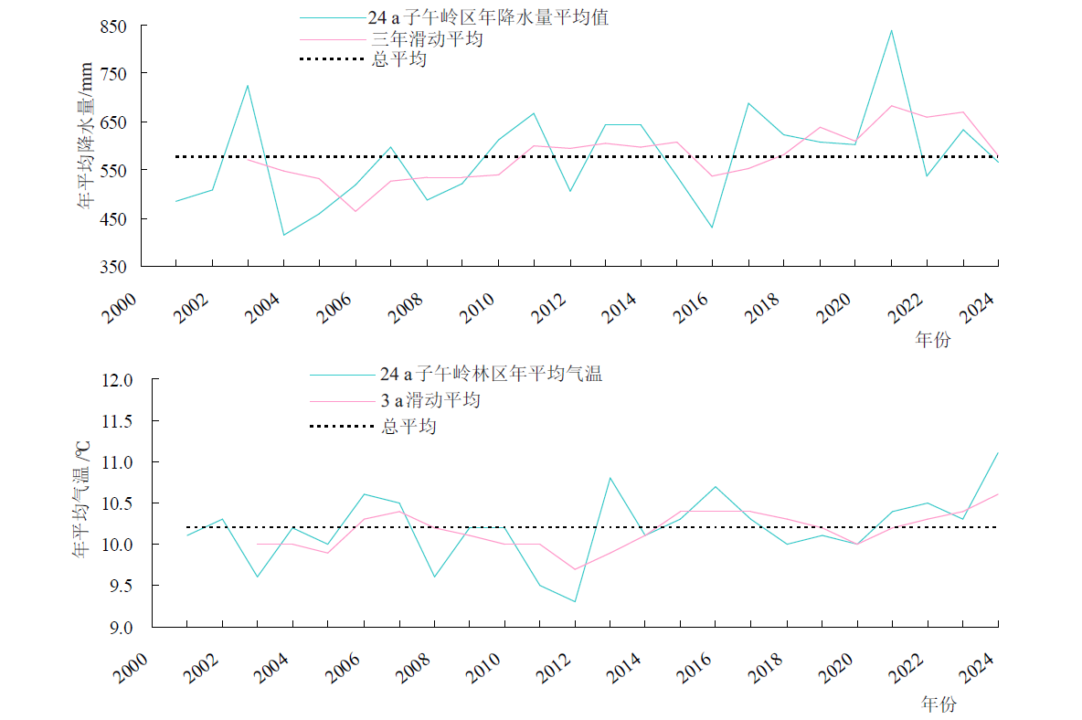
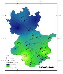
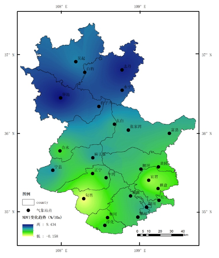
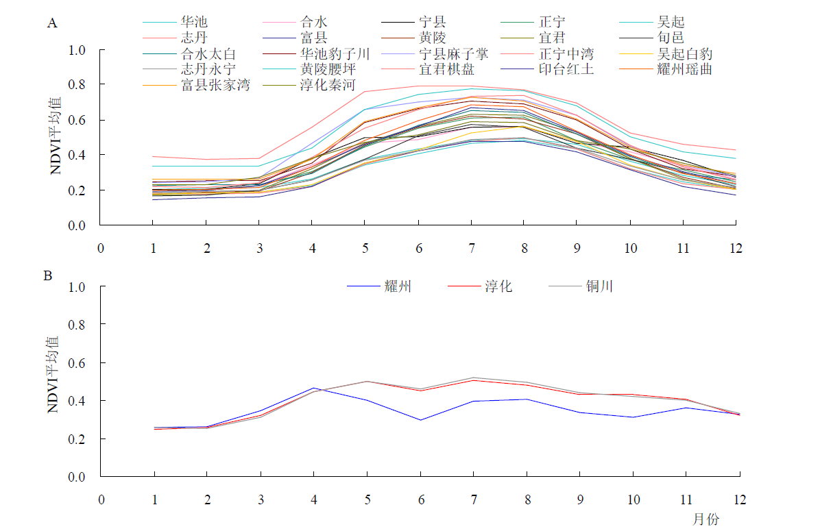
针对子午岭作为黄土高原重要生态屏障,其植被动态对气候响应机制尚不明确的问题,为揭示气候变化对该区域生态系统的影响规律、支撑生态保护决策,本研究基于2001—2024年MODIS MOD13Q1 NDVI数据和25个气象站点的气象资料,利用Google Earth Engine平台预处理数据,采用线性趋势法、克里金插值法及Spearman相关性分析法,系统分析植被覆盖时空变化特征及对水热因子的敏感性。结果表明:(1)时空变化规律:近24 a来,子午岭地区NDVI总体呈显著上升趋势[4%/10a (p<0.0001)],年际波动明显。空间上,NDVI均值呈现“南高北低、主脉高、周边低”的格局,北部(华池、志丹)改善显著(速率5.0%~9.4%/10a),南部局部区域(旬邑)趋于稳定或轻微退化;年内变化主要呈单峰型,峰值出现在7—8月,南部3个站点(耀州、淳化、铜川)呈6月回落的双峰型。(2)气候敏感性分析:年尺度上,植被对降水的敏感性显著高于气温。正宁、淳化等5个站点NDVI与年降水量呈极显著正相关(r=0.458~0.608),水分是主要限制因子;仅宁县站点NDVI与气温呈显著正相关(r=0.436)。月尺度上,7月生长旺季,耀州、淳化等5个站点NDVI与当月降水呈极显著正相关(r=0.549~0.654),气温响应呈空间分异,淳化、耀州、华池、志丹4个站点与当月气温呈显著负相关(r=-0.417~-0.543),即时水热响应占主导地位,滞后效应不明显。(3)主导机制辨析:植被变化受气候与人类活动共同驱动。降水是年际波动的关键因子,尤其在干旱半干旱区;而退耕还林等生态工程可能削弱局部气候信号。空间异质性源于地形、土壤及植被类型差异,如黄土层储水能力缓冲短期气候波动。子午岭植被覆盖整体改善,但北部改善显著、南部局部退化,空间异质性突出。降水是植被生长的核心气候驱动因子,尤其在生长旺季(7月),而气温作用具有促进或抑制双重性。建议实施分区管理、优化水资源配置,加强高温胁迫应对,并持续推进生态工程。本研究为子午岭生态保护提供了科学依据,未来可结合高分辨率数据与生态模型深化机制研究。

关键词: 植被覆盖, 时空分布, 气候敏感性, 森林保护, 子午岭, 黄土高原, 生态屏障

Abstract:

As an important ecological barrier of the Loess Plateau, the response mechanism of vegetation dynamics to climate change in Ziwuling is still unclear. To elucidate the impacts of climate change on regional ecosystems and inform conservation decision-making, this study analyzed spatiotemporal variations in vegetation cover and its sensitivity to hydrothermal factors using MODIS MOD13Q1 NDVI data from 2001-2024 and meteorological records from 25 weather stations. Data preprocessing was conducted via the Google Earth Engine platform, followed by analyses employing linear trend analysis, Kriging interpolation, and Spearman correlation analysis. The results indicate: (1) Spatiotemporal patterns: Over the past 24 years, NDVI in the Ziwuling region exhibited a significant upward trend [4%/10a (p<0.0001)] with pronounced interannual variability. Spatially, mean NDVI followed a "high in the south, low in the north; high along the main ridge, low in surrounding areas" pattern. Notable improvement occurred in the northern sector (Huachi, Zhidan) at rates of 5.0%-9.4%/10a, while localized areas in the south (Xunyi) remained stable or experienced slight degradation. Intra-annual variations predominantly showed a unimodal distribution peaking in July-August, though three southern stations (Yaozhou, Chunhua, Tongchuan) displayed a bimodal pattern with a June decline. (2) Climate sensitivity: At the annual scale, vegetation demonstrated significantly greater sensitivity to precipitation than to temperature. NDVI at five stations (Zhengning, Chunhua, et al.) showed extremely significant positive correlations with annual precipitation (r=0.458 to 0.608), identifying moisture as the primary limiting factor; only Ningxian station exhibited a significant positive correlation with temperature (r=0.436). At the monthly scale, during the peak growing season in July, NDVI at five stations (Yaozhou, Chunhua, et al.) showed extremely significant positive correlations with concurrent precipitation (r=0.549 to 0.654). Temperature responses exhibited spatial heterogeneity: four stations (Chunhua, Yaozhou, Huachi, Zhidan) showed significant negative correlations with concurrent temperature (r=-0.417 to -0.543), indicating dominant immediate hydrothermal responses with negligible lag effects. (3) Mechanistic interpretation: Vegetation changes were driven by both climatic factors and human activities. Precipitation emerged as the key driver of interannual variability, particularly in arid and semi-arid zones, while ecological restoration programs such as the Grain-for-Green Project may have attenuated local climate signals in certain areas. Spatial heterogeneity originated from variations in topography, soil properties, and vegetation types, such as the water-storage capacity of loess deposits to buffer short-term climatic fluctuations. Overall, vegetation cover in Ziwuling has improved, with significant enhancement in the north but localized degradation in the south, highlighting marked spatial heterogeneity. Precipitation constitutes the core climatic driver of vegetation growth, especially during the peak growing season (July), whereas temperature effects are dualistic, capable of either promoting or inhibiting growth. We recommend implementing zoned management strategies, optimizing water resource allocation, enhancing responses to high-temperature stress, and continuing ecological restoration efforts. This study provides a scientific foundation for ecosystem conservation in Ziwuling; future research should integrate high-resolution data with ecological models to deepen mechanistic understanding.

Key words: vegetation cover, spatio-temporal distribution, climate sensitivity, forest conservation, Ziwuling mountains, Loess Plateau, ecological barrier