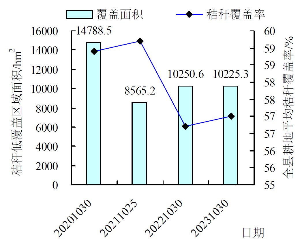
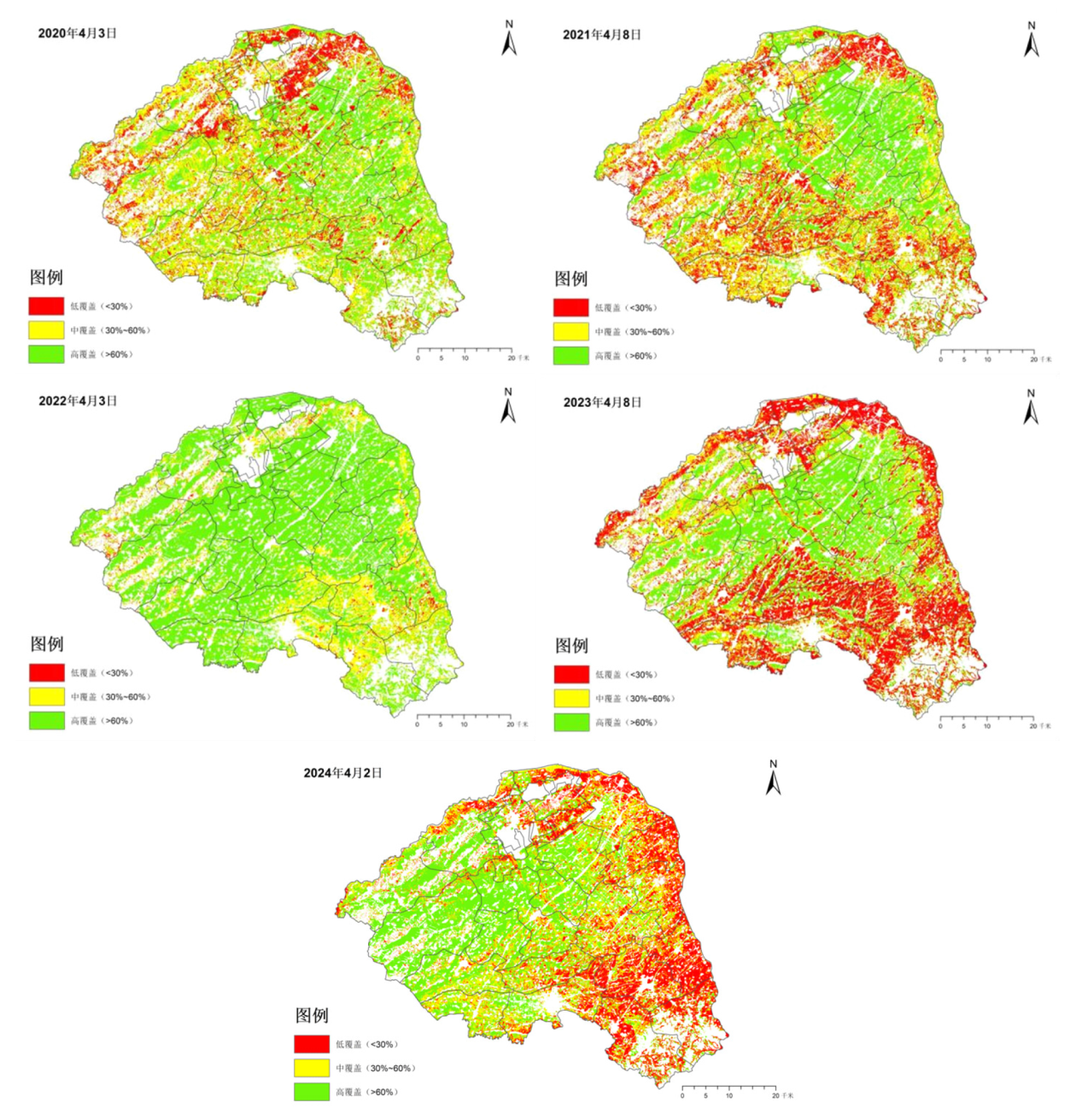
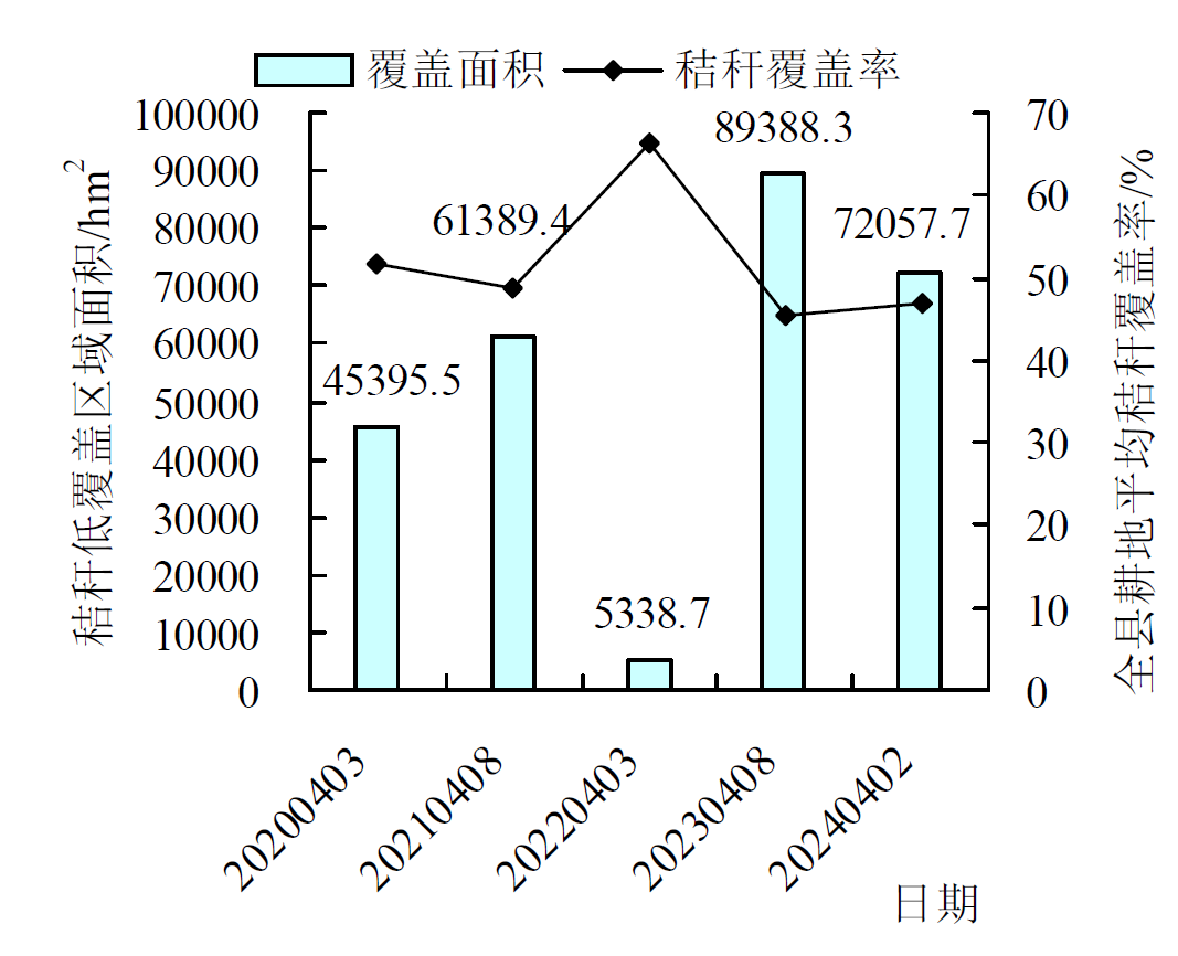
| [1] |
王东印, 裴莉. 浅析我国黑土地现状及保护[J]. 中国农村科技, 2022(1):16-19.
|
| [2] |
韩晓增, 邹文秀, 杨帆. 东北黑土地保护利用取得的主要成绩、面临挑战与对策建议[J]. 中国科学院院刊, 2021, 36(10):1194-1202.
|
| [3] |
高佳, 朱耀辉, 赵荣荣. 中国黑土地保护:政策演变、现实障碍与优化路径[J]. 东北大学学报:社会科学版, 2024, 26(1):82-89.
|
| [4] |
王治统, 凌俊, 刘子熙, 等. 秸秆还田方式对土壤理化性质和玉米产量的影响[J]. 中国生态农业学报(中英文), 2024, 32(4):663-674.
|
| [5] |
翟建宝, 程飞雁, 王振宇. 秸秆资源卫星遥感监测应用[J]. 卫星应用, 2023(10):8-12.
|
| [6] |
宋依依, 曹阳, 段鑫盈, 等. 秸秆还田深度对土壤团聚体组成及有机碳含量的影响[J]. 土壤, 2022, 54(2):344-350.
|
| [7] |
胡雪纯, 解文艳, 马晓楠, 等. 长期秸秆还田对旱地玉米土壤有机碳及碳库管理指数的影响[J]. 中国农学通报, 2022, 38(34):8-13.
doi: 10.11924/j.issn.1000-6850.casb2021-1181
|
| [8] |
吴婕, 朱钟麟, 郑家国, 等. 秸秆覆盖还田对土壤理化性质及作物产量的影响[J]. 西南农业学报, 2006(2):192-195.
|
| [9] |
王如芳, 张吉旺, 董树亭, 等. 我国玉米主产区秸秆资源利用现状及其效果[J]. 应用生态学报, 2011, 22(6):1504-1510.
|
| [10] |
朱奇磊. 基于多源影像的作物秸秆覆盖度遥感估测研究[D]. 合肥: 安徽大学, 2022.
|
| [11] |
李厚萱. 桦川县秸秆覆盖度遥感估算及时空分布特征研究[D]. 哈尔滨: 东北农业大学, 2020.
|
| [12] |
项小云, 杜嘉, 赵博宇, 等. 松嫩平原典型农区玉米秸秆覆盖度遥感估算[J]. 土壤与作物, 2021, 10(3):282-293.
|
| [13] |
黄晋宇, 刘忠, 万炜, 等. 基于土壤异质背景的玉米秸秆覆盖度遥感反演[J]. 应用生态学报, 2020, 31(2):474-482.
|
| [14] |
吴青云, 高飞, 李振轩, 等. Sentinel-2A与Landsat 8数据在植被覆盖度遥感估算中的比较[J]. 测绘通报, 2021(S1):104-108,113.
|
| [15] |
吉林省农业农村厅. 吉林省农业农村厅关于印发《2023年吉林省保护性耕作行动计划技术指引》的通知.http://xxgk.jl.gov.cn/zcbm/fgw_98047/xxgkmlqy/202303/t20230316_8679900.html.
|
 ), QU Ran1(