欢迎访问《农学学报》,
农学学报 ›› 2025, Vol. 15 ›› Issue (10): 18-27.doi: 10.11923/j.issn.2095-4050.cjas2024-0166
张涛( ), 刘媛媛(), 李亚孺, 侯骞
收稿日期:2024-08-14
修回日期:2024-12-20
出版日期:2025-10-20
发布日期:2025-10-17
通讯作者:
作者简介:张涛,男,1976年出生,甘肃平凉人,高级农艺师,本科,主要从事农业技术推广工作。通信地址:744000 甘肃省平凉市崆峒区广成路222号,Tel:0933-8296841,E-mail:615124473@qq.com。
基金资助:
ZHANG Tao(), LIU Yuanyuan(), LI Yaru, HOU Qian
Received:2024-08-14
Revised:2024-12-20
Online:2025-10-20
Published:2025-10-17
摘要:
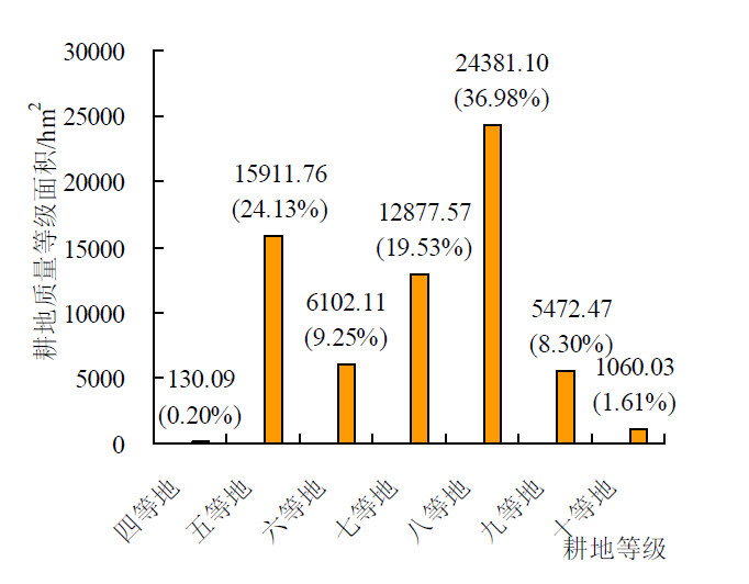
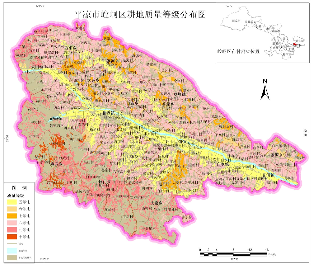
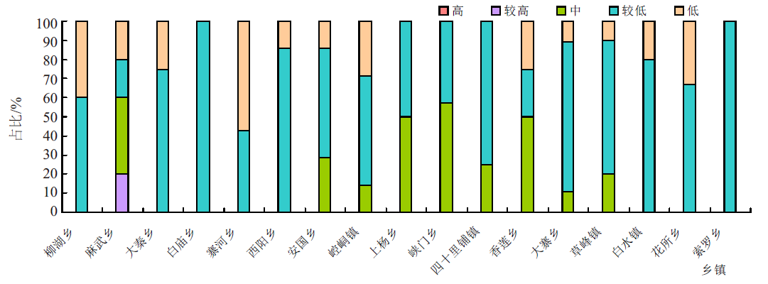
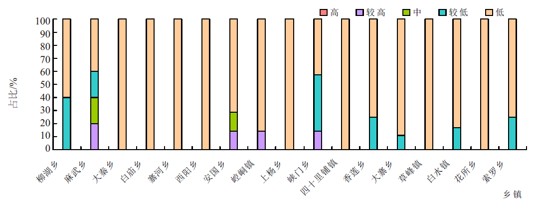
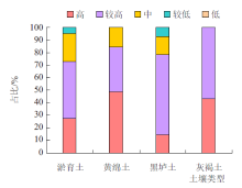
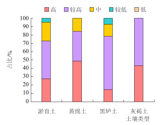
本研究旨在全面掌握甘肃省平凉市崆峒区耕地质量等级及土壤养分特征,为今后崆峒区耕地质量分区管理、保护与利用提供科学依据。利用崆峒区2021年耕地质量等级评价数据,基于GIS技术,对区域内耕地质量等级及土壤养分特征进行研究。结果表明:崆峒区耕地质量整体偏低,分布为四至十等地,八等地为主体耕地。其中,四至六等地占全区耕地总面积的33.58%,主要分布在四十里铺镇、白水镇、花所乡、草峰镇、大寨回族乡、大秦回族乡和峡门回族乡;七至十等地占全区耕地总面积的66.42%,主要分布在草峰镇、大寨回族乡、索罗乡、四十里铺镇、安国乡、西阳回族乡、麻武乡和峡门回族乡。崆峒区耕地土壤有机质含量多属低等水平,平均含量为14.99 g/kg;全氮含量多属低等和较低等水平,平均含量为0.78 g/kg;有效磷含量多属较低等和中等水平,平均含量为17.98 mg/kg;速效钾含量多属较高等水平,平均含量为318.67 mg/kg。几种主要土类中,淤育土有机质和全氮平均含量最低,黑垆土有效磷和速效钾平均含量最低。崆峒区耕地质量提升重点在于增施有机肥,提高氮肥利用率,加大中低产田改良力度,实行符合崆峒区实际的耕地轮作休耕制度,提高耕地集约利用程度,促进耕地资源永续利用。
张涛, 刘媛媛, 李亚孺, 侯骞. 基于GIS的崆峒区耕地质量等级及土壤养分特征研究[J]. 农学学报, 2025, 15(10): 18-27.
ZHANG Tao, LIU Yuanyuan, LI Yaru, HOU Qian. Research on Quality Grade of Cultivated Land and Soil Nutrient Characteristics in Kongtong District Based on GIS[J]. Journal of Agriculture, 2025, 15(10): 18-27.
| 目标层 | 准则层 | 指标层 | 指标权重 | 组合权重 |
|---|---|---|---|---|
| 质量评价 | 土壤管理 | 灌溉能力 | 0.1479 | 0.1823 |
| 排水能力 | 0.0344 | |||
| 立地条件 | 海拔 | 0.0667 | 0.2309 | |
| 地形部位 | 0.1375 | |||
| 农田林网化 | 0.0267 | |||
| 土壤养分 | 有机质 | 0.0996 | 0.2308 | |
| 有效磷 | 0.0718 | |||
| 速效钾 | 0.0594 | |||
| 理化性状 | 耕层质地 | 0.0707 | 0.1446 | |
| 土壤容重 | 0.0389 | |||
| pH | 0.035 | |||
| 剖面性状 | 质地构型 | 0.0639 | 0.1604 | |
| 有效土层厚 | 0.0558 | |||
| 障碍因素 | 0.0407 | |||
| 健康状况 | 生物多样性 | 0.028 | 0.051 | |
| 清洁程度 | 0.023 |
| 指标名称 | 函数类型 | 函数公式 | a值 | b值 | c值 | U1值 | U2值 |
|---|---|---|---|---|---|---|---|
| pH | 峰型 | y=1/[1+a*(u-c)^2] | 0.225097 | 6.685037 | 0.4 | 13.0 | |
| 有机质 | 戒上型 | y=1/[1+a*(u-c)^2] | 0.006107 | 27.680348 | -10.7 | 27.7 | |
| 速效钾 | 戒上型 | y=1/[1+a*(u-c)^2] | 0.000026 | 293.758384 | -295 | 294 | |
| 有效磷 | 戒上型 | y=1/v1+a*(u-c)^2] | 0.001821 | 38.076968 | -32.2 | 38.1 | |
| 土壤容重 | 峰型 | y=1/[1+a*(u-c)^2] | 13.854674 | 1.250789 | 0.44 | 2.05 | |
| 有效土层厚 | 戒上型 | y=1/[1+a*(u-c)^2] | 0.000232 | 131.349274 | -66 | 131 | |
| 海拔 | 戒下型 | y=1/[1+a*(u-c)^2] | 0.000001 | 649.407006 | 649.4 | 3649.4 |
| 评价指标 | 指标属性(隶属度) |
|---|---|
| 地形部位 | 冲积平原(1)、河谷平原(1)、河谷阶地(0.9)、洪积平原(0.85)、黄土塬(0.8)、黄土台塬(0.7)、 河漫滩(0.7)、低台地(0.7)、黄土残塬(0.65)、低丘陵(0.65)、黄土坪(0.65)、高台地(0.65)、黄土墹(0.65)、 黄土梁(0.6)、高丘陵(0.6)、低山(0.5)、黄土峁(0.5)、固定沙地(0.4)、风蚀地(0.4)、中山(0.4)、半固定沙地(0.3)、 流动沙地(0.2)、高山(0.2)、极高山(0.2) |
| 耕层质地 | 砂土(0.4)、砂壤(0.6)、轻壤(0.85)、中壤(1)、重壤(0.8)、黏土(0.6) |
| 质地构型 | 薄层型(0.4)、松散型(0.4)、紧实型(0.6)、夹层型(0.5)、上紧下松型(0.7)、上松下紧型(1.0)、海绵型(0.9) |
| 生物多样性 | 丰富(1.0)、一般(0.7)、不丰富(0.4) |
| 清洁程度 | 清洁(1.0)、尚清洁(0.7)、轻度污染(0.5)、中度污染(0.3)、重度污染(0.0) |
| 障碍因素 | 盐碱(0.4)、瘠薄(0.6)、酸化(0.7)、渍潜(0.5)、障碍层次(0.5)、无(1.0) |
| 灌溉能力 | 充分满足(1.0)、满足(0.7)、基本满足(0.5)、不满足(0.3) |
| 排水能力 | 充分满足(1.0)、满足(0.7)、基本满足(0.5)、不满足(0.3) |
| 农田林网化 | 高(1.0)、中(0.7)、低(0.4) |
| 指标 | 分级 | ||||
|---|---|---|---|---|---|
| 一级(高) | 二级(较高) | 三级(中) | 四级(较低) | 五级(低) | |
| 有机质/(g/kg) | >40.0 | 30.0~40.0 | 20.0~30.0 | 10.0~20.0 | ≤10.0 |
| 全氮/(g/kg) | >2.00 | 1.50~2.00 | 1.25~1.50 | 1.00~1.25 | ≤1.00 |
| 有效磷/(mg/kg) | >40.0 | 25.0~40.0 | 15.0~25.0 | 6.0~15.0 | ≤6.0 |
| 速效钾/(mg/kg) | >300 | 250~300 | 200~250 | 150~200 | ≤150 |

| 乡镇名称 | 面积(hm2)/比例(%) | ||||||
|---|---|---|---|---|---|---|---|
| 四等地 | 五等地 | 六等地 | 七等地 | 八等地 | 九等地 | 十等地 | |
| 安国镇 | — | 971.51/6.11 | 11.62/0.19 | — | 3143.63/12.89 | 847.15/15.69 | 20/1.89 |
| 白庙回族乡 | — | 66.69/0.42 | 647.23/10.61 | 313.13/2.43 | 1345.84/5.52 | — | — |
| 白水镇 | — | 2587.55/16.26 | 87.34/1.43 | 922.28/7.16 | 943.8/3.87 | — | — |
| 草峰镇 | — | — | 1617.98/26.52 | 1891.31/14.69 | 5369.79/22.03 | — | — |
| 大秦回族乡 | — | 3.36/0.02 | 1394.19/22.85 | 3.73/0.03 | 1211.7/4.97 | — | — |
| 大寨回族乡 | 10.7/8.23 | 1382.17/8.69 | — | 2660.97/20.66 | 1592.14/6.53 | 559.5/10.36 | 6.9/0.65 |
| 东关街道 | — | 113.69/0.71 | — | 4.34/0.03 | — | — | — |
| 花所镇 | — | 1632.23/10.26 | — | 515.87/4.01 | 650.37/2.67 | — | — |
| 崆峒镇 | — | 1169.79/7.35 | 158.59/2.60 | 599.97/4.66 | 964.48/3.96 | 429.82/7.96 | 27.31/2.58 |
| 柳湖镇 | — | 904.89/5.69 | 72.98/1.20 | 393.64/3.06 | 292.83/1.20 | — | — |
| 麻武乡 | — | — | — | — | — | 1478.51/27.38 | 765.77/72.24 |
| 上杨回族乡 | — | 1002.17/6.30 | — | 505.58/3.93 | 273.39/1.12 | 9.62/0.18 | — |
| 四十里铺镇 | 118.44/91.04 | 3285.82/20.65 | 49.84/0.82 | 1232.1/9.57 | 317.84/1.30 | — | — |
| 索罗乡 | — | — | 333.1/5.46 | 1501.26/11.66 | 379.35/1.56 | — | — |
| 太统林场 | — | — | — | — | 9.96/0.04 | 47.53/0.88 | 1.02/0.00 |
| 土谷堆林场 | — | 0.95/0.01 | 3.38/0.06 | — | 24.02/0.10 | 39.29/0.73 | — |
| 西郊街道 | — | 17.75/0.11 | — | 0.08/0.00 | — | — | — |
| 西阳回族乡 | — | 647.67/4.07 | 343.85/5.63 | 1.52/0.01 | 3909.27/16.04 | 102.23/1.89 | — |
| 峡门回族乡 | 0.95/0.73 | 511.27/3.21 | — | 1163.94/9.04 | 496.4/2.04 | 1958.82/36.28 | 239.03/22.55 |
| 香莲乡 | — | 819.01/5.15 | 499.57/8.19 | 778.9/6.05 | 1203.89/4.94 | — | — |
| 寨河回族乡 | — | 787.14/4.95 | 882.44/14.46 | 388.85/3.02 | 2251.98/9.24 | — | — |
| 中街街道 | — | 8.1/0.05 | — | 0.1/0.00 | 0.42/0.00 | — | — |
| 土类 | 面积(hm2)/比例(%) | ||||||
|---|---|---|---|---|---|---|---|
| 四等地 | 五等地 | 六等地 | 七等地 | 八等地 | 九等地 | 十等地 | |
| 潮土 | — | 852.37/5.36 | 10.54/0.17 | — | 37.89/0.16 | 1.05/0.02 | — |
| 黑垆土 | 10.13/7.79 | 638.45/4.01 | 3645.16/59.14 | 2908.77/22.59 | 3884.72/15.93 | 0.03/0.00 | — |
| 红土 | — | 67.79/0.43 | — | 0.84/0.01 | 160.45/0.66 | 1289.38/23.88 | 524.19/49.45 |
| 黄绵土 | 30.7/23.60 | 7118.49/44.74 | 2433.86/39.89 | 9857.54/76.55 | 19598.3/80.39 | 1305.85/24.18 | 9.99/0.94 |
| 灰褐土 | — | 1.03/0.01 | 3.42/0.06 | 1.83/0.01 | 214.46/0.88 | 2794.79/51.76 | 525.85/49.61 |
| 淤育土 | 89.26/68.61 | 7233.26/45.46 | 9.13/0.15 | 108.59/0.84 | 483.5/1.98 | 8.71/0.16 | — |
| 养分种类 | 样本数/个 | 最小值 | 最大值 | 平均值 | 标准差 | 变异系数/% |
|---|---|---|---|---|---|---|
| 有机质/(g/kg) | 99 | 4.2 | 31 | 14.99 | 5.59 | 37.27 |
| 全氮/(g/kg) | 99 | 0.34 | 1.79 | 0.78 | 0.30 | 38.77 |
| 有效磷/(mg/kg) | 99 | 3.1 | 62.1 | 17.98 | 12.25 | 68.12 |
| 速效钾/(mg/kg) | 99 | 168 | 808 | 318.67 | 98.84 | 31.02 |
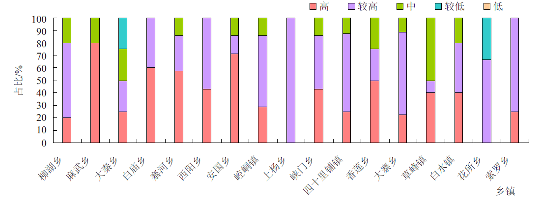
| 乡镇 | 有机质/(g/kg) | 全氮/(g/kg) | 有效磷/(mg/kg) | 速效钾/(mg/kg) |
|---|---|---|---|---|
| 柳湖乡 | 11.26 | 0.82 | 33.92 | 369.00 |
| 麻武乡 | 19.56 | 1.09 | 24.74 | 434.80 |
| 大秦回族乡 | 11.20 | 0.63 | 13.68 | 321.50 |
| 白庙回族乡 | 16.34 | 0.97 | 12.18 | 355.20 |
| 寨河回族乡 | 10.84 | 0.63 | 24.89 | 341.71 |
| 西阳回族乡 | 12.91 | 0.77 | 19.51 | 322.29 |
| 安国乡 | 14.75 | 0.85 | 22.58 | 332.67 |
| 崆峒镇 | 15.07 | 0.89 | 15.21 | 281.57 |
| 上杨回族乡 | 19.55 | 0.71 | 9.45 | 287.00 |
| 峡门回族乡 | 19.26 | 1.05 | 19.46 | 306.29 |
| 四十里铺镇 | 18.13 | 0.70 | 10.11 | 283.38 |
| 香莲乡 | 17.10 | 0.80 | 17.70 | 335.00 |
| 大寨回族乡 | 14.11 | 0.80 | 16.30 | 300.78 |
| 草峰镇 | 15.91 | 0.55 | 17.22 | 289.00 |
| 白水镇 | 12.48 | 0.70 | 16.02 | 347.20 |
| 花所乡 | 12.43 | 0.71 | 19.07 | 229.33 |
| 索罗乡 | 14.80 | 0.81 | 10.45 | 281.50 |


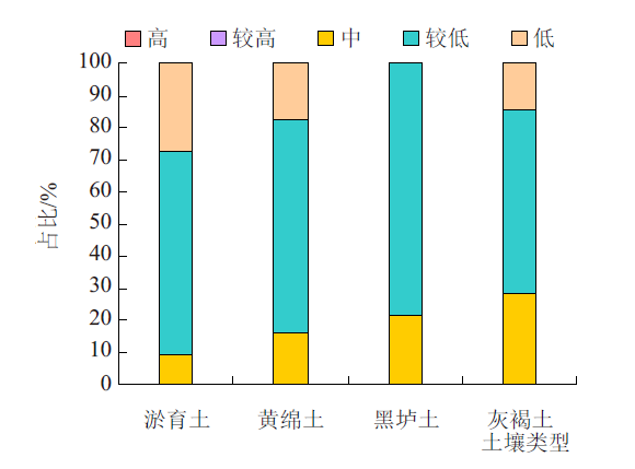
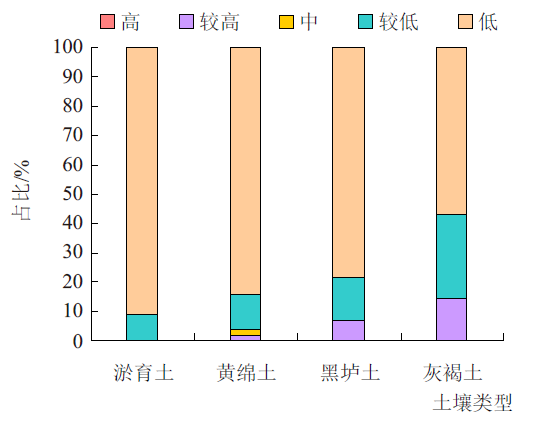
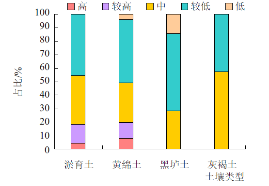
| 土类 | 有机质/(g/kg) | 全氮/(g/kg) | 有效磷/(mg/kg) | 速效钾/(mg/kg) |
|---|---|---|---|---|
| 淤育土 | 13.64 | 0.71 | 18.72 | 304.23 |
| 黄绵土 | 14.51 | 0.75 | 18.90 | 321.92 |
| 黑垆土 | 17.29 | 0.84 | 12.07 | 289.50 |
| 灰褐土 | 14.91 | 0.96 | 15.91 | 315.71 |
| 土类 | 有机质/(g/kg) | 全氮/(g/kg) | 有效磷/(mg/kg) | 速效钾/(mg/kg) |
|---|---|---|---|---|
| 淤育土 | 13.64 | 0.71 | 18.72 | 304.23 |
| 黄绵土 | 14.51 | 0.75 | 18.90 | 321.92 |
| 黑垆土 | 17.29 | 0.84 | 12.07 | 289.50 |
| 灰褐土 | 14.91 | 0.96 | 15.91 | 315.71 |


| [1] |
潘雪, 蔡立群, 董博, 等. 平川区耕地质量等级及养分特征分析研究[J]. 中国农学通报, 2022, 38(29):118-128.
doi: 10.11924/j.issn.1000-6850.casb2021-1074 |
| [2] |
程锋, 王洪波, 郧文聚. 中国耕地质量等级调查与评定[J]. 中国土地科学, 2014, 28(2):75-82,97.
|
| [3] |
冯耀祖, 耿庆龙, 陈署晃, 等. 基于GIS的县级耕地地力评价及土壤障碍因素分析[J]. 新疆农业科学, 2011, 48(12):2281-2288.
|
| [4] |
许彩彩, 吕春娟, 陈卓, 等. 新时期耕地自然质量空间分异特征分析[J]. 山西农业科学, 2021, 49(1):69-75.
|
| [5] |
杨玲, 王增刚. 基于耕地质量等级评价的高标准基本农田建设研究[J]. 江西测绘, 2013, 98(4):59-62.
|
| [6] |
尹成杰. 切实加大耕地保护建设力度牢牢守住18亿亩红线[J]. 中国农垦, 2022(4):4-8.
|
| [7] |
李效顺, 曲福田, 谭荣, 等. 中国耕地资源变化与保护研究——基于土地督查视角的考察[J]. 自然资源学报, 2009, 24(3):387-401.
doi: 10.11849/zrzyxb.2009.03.003 |
| [8] |
张敏. 耕地质量评价方法研究概述[J]. 农村经济与技, 2020, 31(21):10-12.
|
| [9] |
陈朝, 陈进栋, 吴乐芹, 等. 基于Model Builder的垦造水田耕地质量等别评价[J]. 中国农学通报, 2021, 37(11):71-78.
doi: 10.11924/j.issn.1000-6850.casb2020-0260 |
| [10] |
李靖懿, 卢霞, 张赟. 耕地质量和耕地产能评价方法与实证研究——以湖南省道县为例[J]. 国土与自然资源研究, 2021, 192(3):20-25.
|
| [11] |
|
| [12] |
江文娟, 汤萌萌, 汪甜甜, 等. 宣城市耕地质量等级及土壤养分空间分布特征[J]. 土壤通报, 2022, 53(1):36-44.
|
| [13] |
王慧慧, 李子杰, 高沪宁, 等. 基于GIS的岳西县耕地质量等级时空变化研究[J]. 洛阳理工学院学报(自然科学版), 2022, 31(1):1-5.
|
| [14] |
杨佳, 于志军, 王参, 等. 雄安新区不同土地利用方式土壤性状的空间分布特征——以容城县为例[J]. 生态学报, 2021(17):1-9.
|
| [15] |
孙晓兵, 张青璞, 孔祥斌, 等. 华北集约化农区耕地土壤肥力时空演变特征——以河北省曲周县为例[J]. 中国生态农业学报(中英文), 2019, 27(12):1857-1869.
|
| [16] |
谭思佳, 蔡立群. 基于GIS的金塔县耕地质量等级评价及特征分析[J]. 国土与自然资源研究, 2022, 18(5):27-31.
|
| [17] |
潘雪, 关宇淇, 潘占东, 等. 干旱区耕地质量等级时空变化及其评价—以西宁市为例[J]. 干旱区地理, 2023, 46(5):793-802.
doi: 10.12118/j.issn.1000-6060.2022.393 |
| [18] |
段友春. 基于GIS的鲁东南典型丘陵平原区农田土壤养分空间变异特征及影响因素研究[J]. 中国农学报, 2021, 37(23):61-68.
|
| [19] |
马倩倩, 董博, 许旺旺, 等. 干旱区耕地质量等级评价及土壤养分与盐渍化的分析研究—以民勤绿洲为例[J]. 干旱区理, 2021, 44(2):514-524.
|
| [20] |
陈强, 杨劲松, 姚荣江, 等. 河套平原典型县域耕地土壤养分空间变异特征研究[J]. 中国农学通报, 2020, 36(10):102-108.
doi: 10.11924/j.issn.1000-6850.casb20191000781 |
| [21] |
姚东恒, 裴久渤, 汪景宽. 东北典型黑土区耕地质量时空变化研究[J]. 中国生态农业学报(中英文), 2020 (01):104-114.
|
| [22] |
马慧婷. 三江平原区耕地质量评价及时空演变规律研究[D]. 沈阳: 沈阳农业大学, 2017.
|
| [23] |
高一帆. 陕西省土壤养分空间变异及其耕地质量评价研究[D]. 杨凌: 西北农林科技大学, 2019.
|
| [24] |
汪璐. 江西省耕地质量评价及时空变化研究[D]. 南昌: 江西农业大学, 2014.
|
| [25] |
赵建军, 张洪岩, 王野乔, 等. 基于AHP和GIS的省级耕地质量评价研究—以吉林省为例[J]. 土壤通报, 2012, 43(1):70-75.
|
| [26] |
郁杰, 高晖, 李文西. 基于GIS的江苏省耕地质量等级评价[J]. 中国土壤与肥料, 2022(3):222-230.
|
| [27] |
于晓静. 基于GIS和RS技术的肇东市耕地质量评价研究[D]. 哈尔滨: 东北农业大学, 2012.
|
| [28] |
何尹杰, 吴大放, 刘艳艳, 等. 珠海市1982——2009年耕地质量时空演变分析[J]. 广东农业科学, 2017(02):86-94.
|
| [29] |
方灿华, 马友华, 钱国平, 等. 基于GIS的明光市耕地地力评价[J]. 中国农学通报, 2008, 24(12):308-312.
|
| [30] |
龙惠芳, 郭熙, 赵小敏, 等. 基于GIS的县域耕地地力评价研究——以江西省乐平市为例[J]. 江西农业大学学报. 2009, 31(2):359-363.
|
| [31] |
谢叶伟, 赵军, 李勇. 基于GIS的典型黑土区海伦市耕地地力评价研究[J]. 干旱区地理, 2011, 34(2):325-330.
|
| [32] |
徐烨晖. 基于ArcGIS的常熟市耕地土壤养分时空变化研究[D]. 扬州: 扬州大学. 2022.
|
| [33] |
文雯, 罗林涛, 杜金花, 等. 基于GIS的宜章县耕地质量等级评价[J]. 湖南农业科学, 2023(8):76-83.
|
| [34] |
蒋绍淮, 周冬梅, 蔡立群. 山丹县耕地质量评价及肥力分析研究[J]. 国土与自然资源研究, 2023(3):23-28.
|
| [35] |
丁琪洵, 汤萌萌, 李子杰. 涡阳县高标准农田耕地质量等级评价研究[J]. 中国农学通报, 2022, 38(4):46-52.
doi: 10.11924/j.issn.1000-6850.casb2021-0252 |
| [36] |
汪甜甜, 费坤, 江文娟, 等. 宣州区耕地质量等级评价及灌排能力对耕地质量影响[J]. 灌溉排水学报, 2021, 40(11):79-89.
|
| [37] |
侯淑涛, 邸延顺, 程光大, 等. 黑龙江明水县耕地质量综合评价[J]. 水土保持研究, 2015, 22(4):232-236,240.
|
| [38] |
张兴嘉, 蔡立群, 董博. 基于县域耕地资源管理信息系统的土壤综合肥力评价[J]. 水土保持研究, 2012, 19(4):138-141.
|
| [39] |
赵彦锋, 程道全, 陈杰, 等. 耕地地力评价指标体系构建中的问题与分析逻辑[J]. 土壤学报, 2015, 52(6):1197-1208.
|
| [40] |
赵小娟, 叶云, 周晋皓, 等. 珠三角丘陵区耕地质量综合评价及指标权重敏感性分析[J]. 农业工程学报, 2017, 33(8):226-235.
|
| [41] |
孙妍芳, 裴久渤, 张立江, 等. 辽宁棕壤耕地质量评价及障碍因素类型分区研究[J]. 中国农业资源与区划, 2017, 38(11):130-137,144.
|
| [42] |
陈初红, 邹忠, 周鹤. 耕地地力评价因子权重及隶属度的确定[J]. 现代农业科技, 2011(12):280-281.
|
| [43] |
李双异, 刘慧屿, 白伟, 等. 耕地地力演变及其与种植业结构关系分析[J]. 土壤通报, 2016, 47(6):1300-1305.
|
| [44] |
孙剑虹, 张瑞庆, 王欢元, 等. 陕西定边盐渍土土壤含盐量和pH的空间分布特征[J]. 土西北农业学报, 2014, 23(9):114-119.
|
| [45] |
刘媛媛, 涂国良. 平凉市耕地土壤有效态微量元素丰缺评价及影响因素研究[J]. 中国农学通报, 2023, 39(4):83-92.
doi: 10.11924/j.issn.1000-6850.casb2022-0153 |
| [46] |
朱道奇, 张志华, 包鑫丰, 等. 有机肥配施土壤调理剂改善土壤理化性质提高水稻产量[J]. 中南农业科技2024, 45(4):6-9.
|
| [1] | 孙育强, 方竹, 肖辉, 张建发, 贾莹, 李丹琳, 赵燕娜. 宁晋泊—大陆泽低平原区耕地质量评价及土壤养分状况分析研究[J]. 农学学报, 2025, 15(9): 21-29. |
| [2] | 刘雅杰, 刘战勇, 张向前, 路战远, 迟文峰, 程玉臣, 张德健, 孙峰, 刘祾悦, 兰慧青, 白东星. 大兴安岭南麓黑土区阿荣旗耕地质量评价与障碍因素分析[J]. 农学学报, 2024, 14(7): 58-66. |
| [3] | 郑铭宇, 蔡立群. 基于模糊数学方法的金昌市耕地质量评价及土壤养分空间特征分析[J]. 农学学报, 2024, 14(7): 24-35. |
| [4] | 程红梅, 田聪华, 王红梅, 张利召. 基于GIS技术农用地整理潜力测算方法研究——以哈巴河县为例[J]. 农学学报, 2024, 14(10): 87-91. |
| [5] | 邹恒宇, 叶英聪, 匡丽花. 耕地质量与景观格局指数的关系研究——以江西省鹰潭市为例[J]. 农学学报, 2024, 14(1): 44-52. |
| [6] | 朱晓玲. 耕地轮作休耕补助的现状、问题及对策[J]. 农学学报, 2022, 12(6): 85-89. |
| [7] | 郭佳君, 李茜. 基于耕地质量及农作物比较优势的种植业布局优化——以山西省武乡县为例[J]. 农学学报, 2021, 11(11): 118-124. |
| [8] | 钱晨晨,黄国勤,赵其国. 中国轮作休耕制度的应用进展[J]. 农学学报, 2017, 7(3): 37-41. |
| [9] | 于泽西,单晟烨,张冬有. 太阳岛景区水体空气负离子浓度的分析与评价[J]. 农学学报, 2017, 7(12): 52-57. |
| [10] | 张嘉星,齐学斌. 农业灌区机井规划布局研究进展[J]. 农学学报, 2016, 6(2): 96-100. |
| 阅读次数 | ||||||
|
全文 |
|
|||||
|
摘要 |
|
|||||