欢迎访问《农学学报》,

农学学报 ›› 2025, Vol. 15 ›› Issue (8): 39-46.doi: 10.11923/j.issn.2095-4050.cjas2024-0171

• 土壤肥料 资源环境 生态 • 上一篇    下一篇

丰宁县表层土壤有机碳空间分异规律及其影响因素

杨青峰1(), 赵一行1, 郄欣1, 刘华岩2()   

  1. 1 河北省地质矿产勘查开发局国土资源勘查中心,石家庄 050081
    2 河北沧州市农林科学院,河北沧州 061000
  • 收稿日期:2024-08-21 修回日期:2024-11-15 出版日期:2025-08-20 发布日期:2025-08-18
  • 通讯作者:
    刘华岩,女,1998年出生,河北沧州人,硕士,研究方向:资源利用与植物保护。通信地址:061001 河北沧州运河区九河西路, E-mail:
  • 作者简介:

    杨青峰,男,1988年出生,天津宝坻人,高级工程师,硕士,研究方向:水文工程地质。通信地址:050081 河北石家庄桥西区中山西路800号,Tel:029-66106028,E-mail:

  • 基金资助:
    河北省地质矿产勘查开发局项目“典型县域自然资源碳收支核算方法研究——以丰宁县为例”(13000023P0069B4101505)

Spatial Differentiation of Surface Soil Organic Carbon in Fengning County and Its Influencing Factors

YANG Qingfeng1(), ZHAO Yixing1, QIE Xin1, LIU Huayan2()   

  1. 1 Land Resources Exploration Center, Hebei Bureau of Geology and Mineral Resources Exploration and Development, Shijiazhuang 050081
    2 Cangzhou Academy of Agriculture and Forestry Sciences, Cangzhou Hebei 061000
  • Received:2024-08-21 Revised:2024-11-15 Online:2025-08-20 Published:2025-08-18

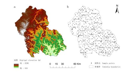
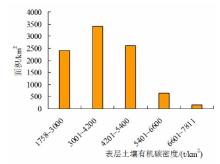
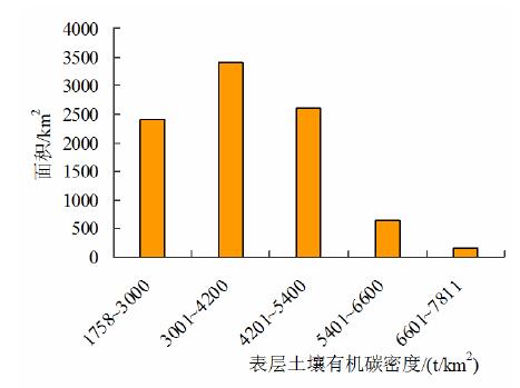
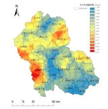
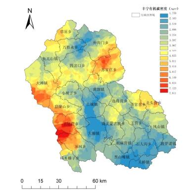
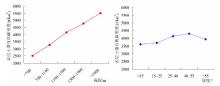
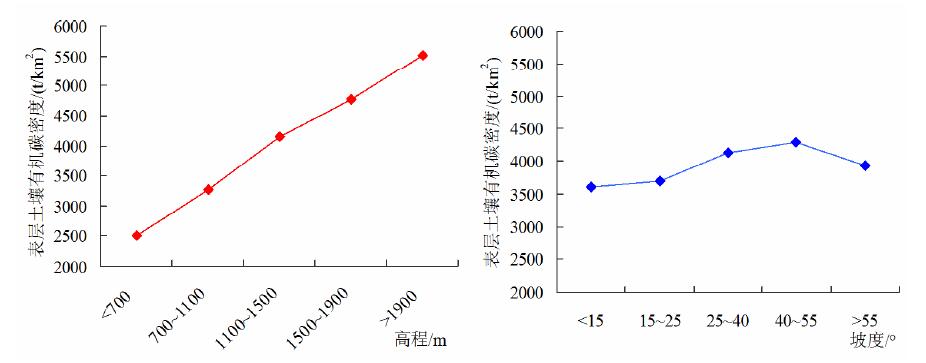
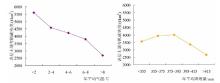
摘要: 为准确估算丰宁县表层土壤有机碳密度及碳储量,确定其空间分布及影响因素。基于2022年采集的283个表层土壤样本,利用地统计学方法和ArcGIS技术分析表层土壤有机碳空间分布特征,并通过区域叠加分析得出影响土壤有机碳密度的重要因素。结果表明:(1)2022年丰宁县表层土壤有机碳密度范围为1759.26~7810.87 t/km2,平均值为3631.41 t/km2,碳储量为32.75 Mt;(2)各乡镇中表层土壤平均有机碳密度最大的是五道营乡,达到5507.58 t/km2,大滩镇表层土壤有机碳储量最多,为2.98 Mt;(3)丰宁县表层土壤有机碳密度具有随海拔增加而增加的趋势,西部地区及东北部坝缘山地有机碳密度较大;不同土地利用方式下表层土壤有机碳密度由高到低依次为草地>林地>滩涂>旱地>裸地>建设用地;紫色土和灰褐土的有机碳密度明显高于其他土壤类型。表层土壤有机碳密度同时受到自然和人为因素影响,想要提高表层土壤有机碳含量,需要综合考虑地形地貌、土壤类型、土地利用方式等多种因素。

关键词: 土壤有机碳密度, 有机碳储量, 空间分布, 影响因素

Abstract:

To accurately estimate the surface soil organic carbon (SOC) density and carbon storage in Fengning County, and to determine their spatial distribution and influencing factors, this study utilized 283 surface soil samples collected in 2022. Geostatistical methods and ArcGIS technology were employed to analyze the spatial distribution characteristics of surface SOC, and regional overlay analysis was conducted to identify key factors influencing SOC density. The results indicated that: (1) in 2022, the surface SOC density in Fengning County ranged from 1759.26 to 7810.87 t/km2, with an average value of 3631.41 t/km2, and a total carbon storage of 32.75 Mt; (2) among the townships, Wudaoying Township had the highest average surface SOC density at 5507.58 t/km2, while Datanzhen had the largest surface SOC storage at 2.98 Mt; (3) surface SOC density showed an increasing trend with elevation, with higher densities observed in the western region and the northeastern edge of the plateau. Across different land use types, the order of surface SOC density from high to low was: grassland > forest land > tidal flats > dryland > bare land > construction land. In terms of soil types, purple soils and grey-brown soils exhibited significantly higher SOC densities compared to other soil types. The study concluded that surface SOC density was influenced by both natural and anthropogenic factors, and enhancing SOC content required a comprehensive consideration of topography, soil types, and land use practices.

Key words: soil organic carbon density, organic carbon storage, spatial distribution, influencing factors