欢迎访问《农学学报》,
农学学报 ›› 2026, Vol. 16 ›› Issue (5): 43-50.doi: 10.11923/j.issn.2095-4050.cjas2025-0048
所属专题: 资源与环境
封鹏飞1( ), 申成龙1, 姜会忠2
收稿日期:2025-02-08
修回日期:2025-07-10
出版日期:2026-05-20
发布日期:2026-05-15
作者简介:封鹏飞,男,1998年出生,助理工程师,硕士,研究方向:土地规划设计。通信地址:250100 山东省济南市历城区工业南路101号北楼4楼 山东智拓地理信息工程有限公司,E-mail:2823586536@qq.com。
FENG Pengfei1(), SHEN Chenglong1, JIANG Huizhong2
Received:2025-02-08
Revised:2025-07-10
Online:2026-05-20
Published:2026-05-15
摘要:
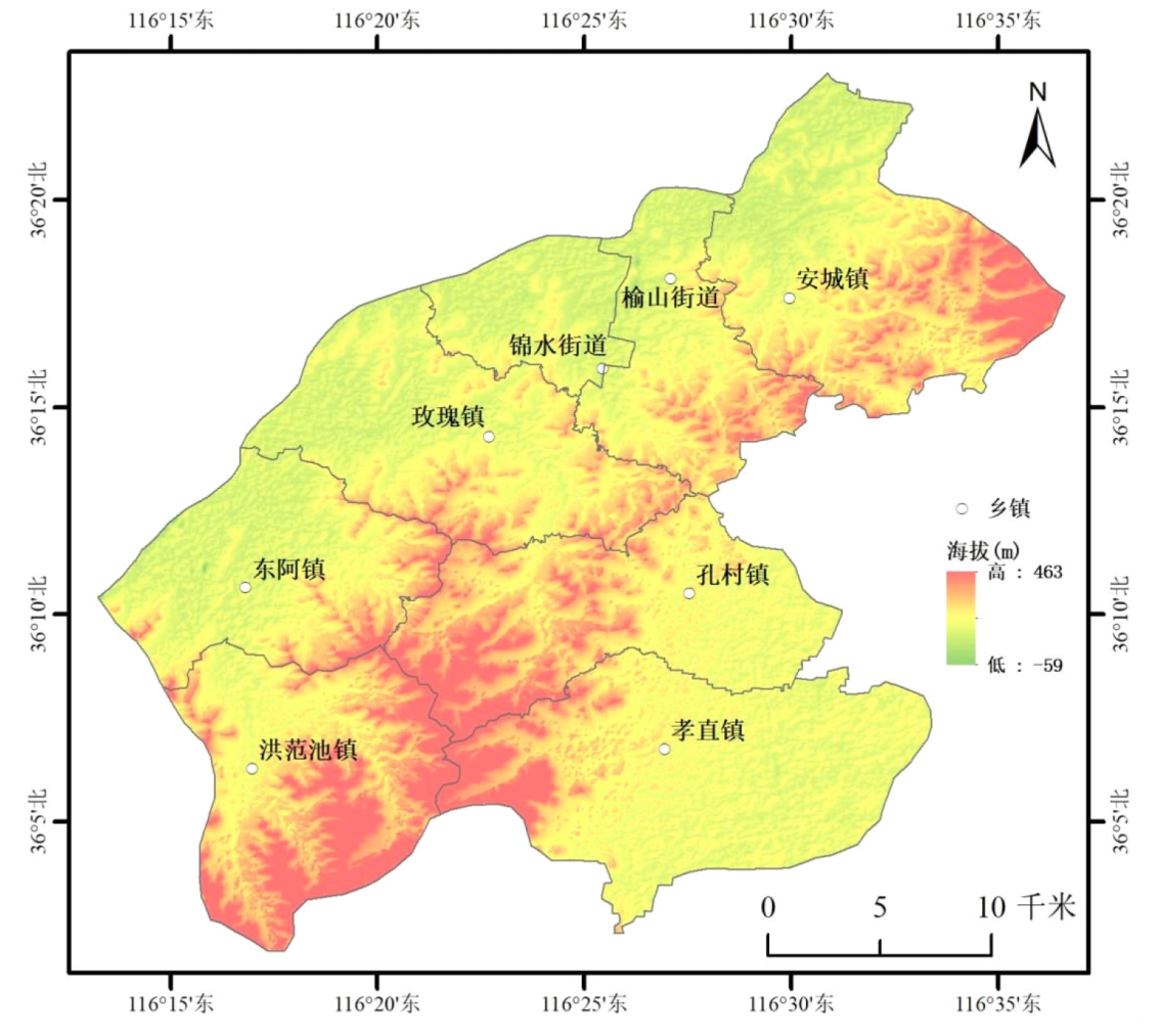
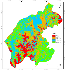
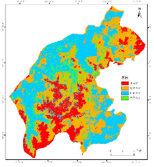
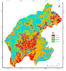
为做好农用地保护工作,提升平阴县农用地利用效率,精准支撑县域土地规划与农业布局优化。本研究以平阴县第三次国土调查土地利用现状数据为基础,整合自然地理与人文社会要素,构建涵盖地形(高程、坡度)、土壤(类型、pH、有机质)、水资源(距水系距离)及人文条件(距道路距离、距居民点距离、土地利用现状)的 9 因子评价指标体系,采用主成分分析法确定因子权重,结合 GIS 空间分析与自然间断点分级法,对平阴县耕地、园地、林地三类农用地开展适宜性评价。结果表明:(1)平阴县耕地高度适宜区占比在33%,集中分布于西北黄河沿岸和东南汇河两岸地区。(2)园地和林地高度适宜区占比约在11%左右,分布较为松散,而南部中部山脉地区普遍适宜性较低。(3)受山脉地形影响,各乡镇农用地适宜性程度不同,空间分布不均匀,特别是孝直镇耕地高度适宜区面积达一半以上。GIS综合适宜性评价旨在识别潜在农用地,为科学规划和优化农用地空间布局提供支撑。
中图分类号:
封鹏飞, 申成龙, 姜会忠. 基于GIS的平阴县农业用地适宜性评价及分析[J]. 农学学报, 2026, 16(5): 43-50.
FENG Pengfei, SHEN Chenglong, JIANG Huizhong. GIS-based Suitability Evaluation and Analysis of Agricultural Land in Pingyin County[J]. Journal of Agriculture, 2026, 16(5): 43-50.
| 数据 | 来源 |
|---|---|
| 土壤类型 | 国家地球系统科学数据中心( |
| 土壤pH | 国家青藏高原科学数据中心 ( |
| 土壤有机质 | |
| 行政区划 | 地理空间数据云( |
| 地形数据 | |
| 交通数据 | OSM数据集 |
| 水系数据 | |
| 土地利用现状 | 第三次全国国土调查 |
| 数据 | 来源 |
|---|---|
| 土壤类型 | 国家地球系统科学数据中心( |
| 土壤pH | 国家青藏高原科学数据中心 ( |
| 土壤有机质 | |
| 行政区划 | 地理空间数据云( |
| 地形数据 | |
| 交通数据 | OSM数据集 |
| 水系数据 | |
| 土地利用现状 | 第三次全国国土调查 |
| 评价因子 | 6分 | 5分 | 4分 | 3分 | 2分 | 1分 |
|---|---|---|---|---|---|---|
| DEM/m | <50 | 50~90 | 90~135 | 135~190 | 190~260 | >260 |
| 坡度/° | <2 | 2~5 | 5~10 | 10~15 | 15~20 | >20 |
| 距水系距离/km | <1.5 | 1.5~3 | 3~5 | >5 | ||
| 距道路距离/km | <1 | 1~2 | 2~3 | 3~4 | 4~5 | >5 |
| 居民点/km | <0.3 | 0.3~0.6 | 0.6~1 | 1~2 | 1.5~2 | >2 |
| 土壤类型 | 褐土、潮褐土、褐土性土 | 潮土 | 石灰性褐土 | 钙质粗骨土 | 石灰性砂姜黑土 | 冲积土、其他 |
| 土壤pH | <7.5 | - | 7.5~8 | - | - | >8 |
| 土壤有机质/(g/kg) | >2.6 | 2.1~2.6 | 1.6~2.1 | 1.2~1.6 | 0.8~1.2 | <0.8 |
| 评价因子 | 耕地 | 园地 | 林地 |
|---|---|---|---|
| DEM | 0.112 | 0.111 | 0.124 |
| 坡度 | 0.123 | 0.124 | 0.176 |
| 距水系距离 | 0.142 | 0.098 | 0.091 |
| 距道路距离 | 0.083 | 0.079 | 0.081 |
| 距居民点距离 | 0.096 | 0.092 | 0.075 |
| 现状用地 | 0.225 | 0.223 | 0.223 |
| 土壤类型 | 0.099 | 0.153 | 0.12 |
| 土壤pH | 0.06 | 0.06 | 0.06 |
| 土壤有机质 | 0.06 | 0.06 | 0.05 |

| 乡镇 | 高度适宜/km2 | 比例/% | 比较适宜/km2 | 比例 | 勉强适宜/km2 | 比例 | 不适宜/km2 | 比例 | 总计/km2 |
|---|---|---|---|---|---|---|---|---|---|
| 孝直镇 | 70.99 | 56.81 | 20.99 | 16.80 | 20.93 | 16.75 | 12.06 | 9.65 | 124.97 |
| 东阿镇 | 30.97 | 38.58 | 25.42 | 31.66 | 15.7 | 19.56 | 8.19 | 10.20 | 80.28 |
| 安城镇 | 37.28 | 33.66 | 22.17 | 20.02 | 37.87 | 34.19 | 13.43 | 12.13 | 110.75 |
| 玫瑰镇 | 30.02 | 31.11 | 33.75 | 34.97 | 26.51 | 27.47 | 6.22 | 6.45 | 96.5 |
| 锦水街道 | 9.21 | 25.60 | 19.75 | 54.91 | 6.8 | 18.90 | 0.21 | 0.58 | 35.97 |
| 孔村镇 | 24.11 | 24.61 | 22.76 | 23.23 | 27.17 | 27.74 | 23.92 | 24.42 | 97.96 |
| 洪范池镇 | 18 | 19.48 | 24.79 | 26.83 | 16.43 | 17.78 | 33.17 | 35.90 | 92.39 |
| 榆山街道 | 10.65 | 17.41 | 28.1 | 45.95 | 19.35 | 31.64 | 3.06 | 5.00 | 61.16 |
| 总计 | 231.23 | 33.03 | 197.73 | 28.25 | 170.76 | 24.39 | 100.26 | 14.32 | 699.98 |

| 乡镇 | 高度适宜/km2 | 比例/% | 比较适宜/km2 | 比例/% | 勉强适宜/km2 | 比例/% | 不适宜/km2 | 比例/% | 总计/km2 |
|---|---|---|---|---|---|---|---|---|---|
| 玫瑰镇 | 16.35 | 16.94 | 46.04 | 47.70 | 27.95 | 28.96 | 6.17 | 6.39 | 96.51 |
| 榆山街道 | 9.58 | 15.66 | 29.16 | 47.67 | 18.94 | 30.96 | 3.49 | 5.71 | 61.17 |
| 锦水街道 | 4.58 | 12.73 | 22.92 | 63.70 | 8.25 | 22.93 | 0.23 | 0.64 | 35.98 |
| 东阿镇 | 8.99 | 11.20 | 37.05 | 46.15 | 24.98 | 31.12 | 9.26 | 11.53 | 80.28 |
| 孔村镇 | 9.83 | 10.04 | 25.63 | 26.17 | 34.34 | 35.06 | 28.15 | 28.74 | 97.95 |
| 安城镇 | 10.5 | 9.48 | 22.69 | 20.49 | 61.15 | 55.22 | 16.39 | 14.80 | 110.73 |
| 孝直镇 | 11.42 | 9.14 | 47.02 | 37.63 | 50.41 | 40.34 | 16.1 | 12.89 | 124.95 |
| 洪范池镇 | 7.51 | 8.13 | 25.1 | 27.16 | 24.47 | 26.48 | 35.32 | 38.23 | 92.4 |
| 总计 | 78.76 | 11.25 | 255.61 | 36.52 | 250.49 | 35.79 | 115.11 | 16.44 | 699.97 |

| 乡镇 | 高度适宜/km2 | 比例/% | 比较适宜/km2 | 比例/% | 勉强适宜/km2 | 比例/% | 不适宜/km2 | 比例/% | 总计/km2 |
|---|---|---|---|---|---|---|---|---|---|
| 玫瑰镇 | 14.83 | 15.37 | 43.63 | 45.21 | 30.36 | 31.46 | 7.69 | 7.97 | 96.51 |
| 安城镇 | 13.92 | 12.57 | 28.03 | 25.31 | 50.23 | 45.36 | 18.56 | 16.76 | 110.74 |
| 东阿镇 | 12.4 | 15.45 | 35.18 | 43.82 | 23.52 | 29.30 | 9.18 | 11.43 | 80.28 |
| 榆山街道 | 8.92 | 14.58 | 31.04 | 50.74 | 16.37 | 26.76 | 4.84 | 7.91 | 61.17 |
| 锦水街道 | 8.14 | 22.62 | 20.36 | 56.59 | 6.79 | 18.87 | 0.69 | 1.92 | 35.98 |
| 洪范池镇 | 7.78 | 8.42 | 27.42 | 29.68 | 33.84 | 36.63 | 23.35 | 25.27 | 92.39 |
| 孔村镇 | 5.84 | 5.96 | 18.16 | 18.54 | 43.73 | 44.65 | 30.22 | 30.85 | 97.95 |
| 孝直镇 | 3.92 | 3.14 | 40.15 | 32.14 | 64.92 | 51.96 | 15.95 | 12.77 | 124.94 |
| 总计 | 75.75 | 10.82 | 243.97 | 34.85 | 269.76 | 38.54 | 110.48 | 15.78 | 699.96 |
| [1] |
韩杨. 中国耕地保护利用政策演进、愿景目标与实现路径[J]. 管理世界, 2022, 38(11):121-131.
|
| [2] |
郑宇, 胡业翠, 刘彦随, 等. 山东省土地适宜性空间分析及其优化配置研究[J]. 农业工程学报, 2005(2):60-65.
|
| [3] |
郭鹏, 管宏梓, 李鹏辉, 等. 基于ArcGIS技术的耕地后备资源调查评价研究——以济南市平阴县为例[J]. 地下水, 2024, 46(5):192-194.
|
| [4] |
江红蕾, 徐霞, 成亚薇, 等. 基于生态可持续的土地利用空间格局分配[J]. 中国农学通报, 2017, 33(33):67-73.
doi: 10.11924/j.issn.1000-6850.casb16110088 |
| [5] |
李德仁. 论RSGPS与GIS集成的定义、理论与关键技术[J]. 遥感学报, 1997(1):64-68.
|
| [6] |
袁媛, 瑚波, 雷蕾, 等. GIS支持下的商南县小麦生态适宜性评价及种植区划[J]. 中国农学通报, 2017, 33(21):7-14.
doi: 10.11924/j.issn.1000-6850.casb16080010 |
| [7] |
赵晓峰, 刘晓煌, 刘玖芬, 等. 基于多环境要素的新疆耕地适宜性评价[J]. 现代地质, 2024, 38(3):718-733.
|
| [8] |
doi: 10.5897/JGRP URL |
| [9] |
doi: 10.1080/00103624.2022.2028807 URL |
| [10] |
陈颖, 吴柏清, 邹卓阳, 等. 基于GIS的土地适宜性评价——以四川省马尔康县为例[J]. 水土保持研究, 2010, 17(4):100-103.
|
| [11] |
陈露露, 杜泳, 颉洪涛. 基于GIS的浙江省诸暨市农业用地适宜性分析与评价[J]. 中国农学通报, 2023, 39(21):158-164.
doi: 10.11924/j.issn.1000-6850.casb2022-0629 |
| [12] |
李潇, 吴克宁, 刘亚男, 等. 基于土地类型的西峡县农用地适宜性评价[J]. 中国农业资源与区划, 2024, 45(1):45-56.
|
| [13] |
潘贤章, 潘恺. 全国土壤标本数据库(1953—2008)[Z].国家地球系统科学数据共享平台-土壤科学数据中心,2015.
|
| [14] |
方华军. 青藏高原地区土壤有机质数据(1979—1985)[Z]. 国家青藏高原科学数据中心.国家青藏高原科学数据中心,2019.
|
| [15] |
李蓉. 基于GIS的七台河市耕地适宜性评价[J]. 哈尔滨师范大学自然科学学报, 2019, 35(4):94-101.
|
| [16] |
伍世代. GIS支持的福清市多目标土地适宜性评价[J]. 福建师范大学学报(自然科学版), 2000(3):87-90.
|
| [17] |
聂艳, 喻婧, 崔灿. 基于GIS和生态位适宜度模型的园地适宜性评价——以湖北宜昌市夷陵区为例[J]. 长江流域资源与环境, 2012, 21(8):1000-1005.
|
| [18] |
李鹏飞. 基于GIS的定西市农用地适宜性评价分析[J]. 河南科技, 2023, 42(5):116-119.
|
| [19] |
李娅, 谭秋, 王丽双, 等. 县域农业土地利用适宜性评价与优化研究——以山西省原平市为例[J]. 中国农业资源与区划, 2022, 43(1):91-99.
|
| [20] |
朱寿红, 殷少美, 唐伟, 等. 基于资源承载力的农用地适宜性评价——以广陵区为例[J]. 江西农业学报, 2021, 33(1):117-122.
|
| [21] |
全国土壤质量标准化技术委员会(SAC/TC 404). GB/T 33469-2016,耕地质量等级[S]. 北京: 中国标准出版社, 2016.
|
| [22] |
李乃强, 徐贵阳. 基于自然间断点分级法的土地利用数据网格化分析[J]. 测绘通报, 2020(4):106-110.
doi: 10.13474/j.cnki.11-2246.2020.0121 |
| [23] |
高尚. 三种计算层次分析法中权值的方法[J]. 科学技术与工程, 2007(20):5204-5207.
|
| [24] |
董君. 层次分析法权重计算方法分析及其应用研究[J]. 科技资讯, 2015, 13(29):218-220.
|
| [25] |
陈德桃, 程文仕. 基于效益最大化的景泰县农地适度经营规模测度及驱动力分析[J]. 国土与自然资源研究, 2025(2):17-21.
|
| [26] |
白璐. 基于适宜性原理的河南省耕地利用强度分析[D]. 开封: 河南大学, 2010.
|
| [1] | 朱丽, 谈嫣蓉, 刘冬皓, 张洋东, 陈文业, 肖云飞, 王斌杰, 邴丹珲. 玛曲县不同土地利用类型对生态环境质量变化的响应[J]. 农学学报, 2025, 15(9): 37-43. |
| [2] | 姬慧, 赵红润, 银超慧, 李玲. 中国农用地土壤重金属污染分区管治研究[J]. 农学学报, 2025, 15(5): 62-71. |
| [3] | 路港滨, 俄胜哲, 袁金华, 张鹏, 刘雅娜, 赵晓龙. 有效态重金属在土壤与作物系统中迁移运转及安全阈值研究[J]. 农学学报, 2025, 15(3): 24-35. |
| [4] | 梁嘉毅, 彭玉玲, 陈知椿. 基于GIS的湖北省农业用地适宜性评价[J]. 农学学报, 2025, 15(2): 33-42. |
| [5] | 刘传鑫, 邱槿敏, 葛雨刚, 孙佳怡, 杨欣桐, 吴冬妍, 王兢磊, 纪予焓, 杜泳, 颉洪涛. 生物入侵防治数字化和智能化策略分析和实施路径研究[J]. 农学学报, 2025, 15(12): 27-33. |
| [6] | 李战超, 张娟娟, 张山清, 吉春容, 胡启瑞. 新疆阿合奇县沙棘精细化气候适宜性区划研究[J]. 农学学报, 2025, 15(12): 86-92. |
| [7] | 李友维, 张骏达, 蔡立群. 基于GIS的民和县耕地土壤养分空间插值方法比较研究[J]. 农学学报, 2025, 15(11): 41-48. |
| [8] | 张涛, 刘媛媛, 李亚孺, 侯骞. 基于GIS的崆峒区耕地质量等级及土壤养分特征研究[J]. 农学学报, 2025, 15(10): 18-27. |
| [9] | 宾幕容. 农户生态养殖技术采纳:作用机理与实证检验——基于环南海地区的微观调查数据[J]. 农学学报, 2024, 14(9): 86-93. |
| [10] | 梁冠, 左红娟, 腊贵晓, 刘永康, 曹辉, 路翠红, 赵正伟, 张晓申. 基于主成分分析和灰色关联度的菊花品种综合评价[J]. 农学学报, 2024, 14(12): 40-44. |
| [11] | 李军营, 杨景华, 邹炳礼, 鲁耀, 周春明, 杨成伟, 李娟, 周敏, 周绍松. 基于大理烟区土壤养分分布状况的烤烟前作适宜性评价[J]. 农学学报, 2024, 14(11): 30-34. |
| [12] | 苑可心, 盖岳峰, 陈修宇, 徐冬云, 陈红艳, 李玉环. 面向农户需求的土壤质量智能分析APP设计与实现[J]. 农学学报, 2024, 14(11): 22-29. |
| [13] | 程红梅, 田聪华, 王红梅, 张利召. 基于GIS技术农用地整理潜力测算方法研究——以哈巴河县为例[J]. 农学学报, 2024, 14(10): 87-91. |
| [14] | 赵金龙, 汪进欣, 马力文. 基于GIS的宁夏皮燕麦种植气候适宜性分析[J]. 农学学报, 2021, 11(9): 79-84. |
| [15] | 张青, 陈鹏. 基于高分六号卫星的植被生态景观监测分析[J]. 农学学报, 2021, 11(7): 56-59. |
| 阅读次数 | ||||||
|
全文 |
|
|||||
|
摘要 |
|
|||||