Welcome to Journal of Agriculture,
Journal of Agriculture ›› 2026, Vol. 16 ›› Issue (5): 43-50.doi: 10.11923/j.issn.2095-4050.cjas2025-0048
Special Issue: 资源与环境
Previous Articles Next Articles
FENG Pengfei1( ), SHEN Chenglong1, JIANG Huizhong2
Received:2025-02-08
Revised:2025-07-10
Online:2026-05-20
Published:2026-05-15
CLC Number:
FENG Pengfei, SHEN Chenglong, JIANG Huizhong. GIS-based Suitability Evaluation and Analysis of Agricultural Land in Pingyin County[J]. Journal of Agriculture, 2026, 16(5): 43-50.
Add to citation manager EndNote|Ris|BibTeX
URL: http://nxxb.caass.org.cn/EN/10.11923/j.issn.2095-4050.cjas2025-0048
| 数据 | 来源 |
|---|---|
| 土壤类型 | 国家地球系统科学数据中心( |
| 土壤pH | 国家青藏高原科学数据中心 ( |
| 土壤有机质 | |
| 行政区划 | 地理空间数据云( |
| 地形数据 | |
| 交通数据 | OSM数据集 |
| 水系数据 | |
| 土地利用现状 | 第三次全国国土调查 |
| 数据 | 来源 |
|---|---|
| 土壤类型 | 国家地球系统科学数据中心( |
| 土壤pH | 国家青藏高原科学数据中心 ( |
| 土壤有机质 | |
| 行政区划 | 地理空间数据云( |
| 地形数据 | |
| 交通数据 | OSM数据集 |
| 水系数据 | |
| 土地利用现状 | 第三次全国国土调查 |
| 评价因子 | 6分 | 5分 | 4分 | 3分 | 2分 | 1分 |
|---|---|---|---|---|---|---|
| DEM/m | <50 | 50~90 | 90~135 | 135~190 | 190~260 | >260 |
| 坡度/° | <2 | 2~5 | 5~10 | 10~15 | 15~20 | >20 |
| 距水系距离/km | <1.5 | 1.5~3 | 3~5 | >5 | ||
| 距道路距离/km | <1 | 1~2 | 2~3 | 3~4 | 4~5 | >5 |
| 居民点/km | <0.3 | 0.3~0.6 | 0.6~1 | 1~2 | 1.5~2 | >2 |
| 土壤类型 | 褐土、潮褐土、褐土性土 | 潮土 | 石灰性褐土 | 钙质粗骨土 | 石灰性砂姜黑土 | 冲积土、其他 |
| 土壤pH | <7.5 | - | 7.5~8 | - | - | >8 |
| 土壤有机质/(g/kg) | >2.6 | 2.1~2.6 | 1.6~2.1 | 1.2~1.6 | 0.8~1.2 | <0.8 |
| 评价因子 | 耕地 | 园地 | 林地 |
|---|---|---|---|
| DEM | 0.112 | 0.111 | 0.124 |
| 坡度 | 0.123 | 0.124 | 0.176 |
| 距水系距离 | 0.142 | 0.098 | 0.091 |
| 距道路距离 | 0.083 | 0.079 | 0.081 |
| 距居民点距离 | 0.096 | 0.092 | 0.075 |
| 现状用地 | 0.225 | 0.223 | 0.223 |
| 土壤类型 | 0.099 | 0.153 | 0.12 |
| 土壤pH | 0.06 | 0.06 | 0.06 |
| 土壤有机质 | 0.06 | 0.06 | 0.05 |

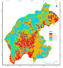
| 乡镇 | 高度适宜/km2 | 比例/% | 比较适宜/km2 | 比例 | 勉强适宜/km2 | 比例 | 不适宜/km2 | 比例 | 总计/km2 |
|---|---|---|---|---|---|---|---|---|---|
| 孝直镇 | 70.99 | 56.81 | 20.99 | 16.80 | 20.93 | 16.75 | 12.06 | 9.65 | 124.97 |
| 东阿镇 | 30.97 | 38.58 | 25.42 | 31.66 | 15.7 | 19.56 | 8.19 | 10.20 | 80.28 |
| 安城镇 | 37.28 | 33.66 | 22.17 | 20.02 | 37.87 | 34.19 | 13.43 | 12.13 | 110.75 |
| 玫瑰镇 | 30.02 | 31.11 | 33.75 | 34.97 | 26.51 | 27.47 | 6.22 | 6.45 | 96.5 |
| 锦水街道 | 9.21 | 25.60 | 19.75 | 54.91 | 6.8 | 18.90 | 0.21 | 0.58 | 35.97 |
| 孔村镇 | 24.11 | 24.61 | 22.76 | 23.23 | 27.17 | 27.74 | 23.92 | 24.42 | 97.96 |
| 洪范池镇 | 18 | 19.48 | 24.79 | 26.83 | 16.43 | 17.78 | 33.17 | 35.90 | 92.39 |
| 榆山街道 | 10.65 | 17.41 | 28.1 | 45.95 | 19.35 | 31.64 | 3.06 | 5.00 | 61.16 |
| 总计 | 231.23 | 33.03 | 197.73 | 28.25 | 170.76 | 24.39 | 100.26 | 14.32 | 699.98 |

| 乡镇 | 高度适宜/km2 | 比例/% | 比较适宜/km2 | 比例/% | 勉强适宜/km2 | 比例/% | 不适宜/km2 | 比例/% | 总计/km2 |
|---|---|---|---|---|---|---|---|---|---|
| 玫瑰镇 | 16.35 | 16.94 | 46.04 | 47.70 | 27.95 | 28.96 | 6.17 | 6.39 | 96.51 |
| 榆山街道 | 9.58 | 15.66 | 29.16 | 47.67 | 18.94 | 30.96 | 3.49 | 5.71 | 61.17 |
| 锦水街道 | 4.58 | 12.73 | 22.92 | 63.70 | 8.25 | 22.93 | 0.23 | 0.64 | 35.98 |
| 东阿镇 | 8.99 | 11.20 | 37.05 | 46.15 | 24.98 | 31.12 | 9.26 | 11.53 | 80.28 |
| 孔村镇 | 9.83 | 10.04 | 25.63 | 26.17 | 34.34 | 35.06 | 28.15 | 28.74 | 97.95 |
| 安城镇 | 10.5 | 9.48 | 22.69 | 20.49 | 61.15 | 55.22 | 16.39 | 14.80 | 110.73 |
| 孝直镇 | 11.42 | 9.14 | 47.02 | 37.63 | 50.41 | 40.34 | 16.1 | 12.89 | 124.95 |
| 洪范池镇 | 7.51 | 8.13 | 25.1 | 27.16 | 24.47 | 26.48 | 35.32 | 38.23 | 92.4 |
| 总计 | 78.76 | 11.25 | 255.61 | 36.52 | 250.49 | 35.79 | 115.11 | 16.44 | 699.97 |

| 乡镇 | 高度适宜/km2 | 比例/% | 比较适宜/km2 | 比例/% | 勉强适宜/km2 | 比例/% | 不适宜/km2 | 比例/% | 总计/km2 |
|---|---|---|---|---|---|---|---|---|---|
| 玫瑰镇 | 14.83 | 15.37 | 43.63 | 45.21 | 30.36 | 31.46 | 7.69 | 7.97 | 96.51 |
| 安城镇 | 13.92 | 12.57 | 28.03 | 25.31 | 50.23 | 45.36 | 18.56 | 16.76 | 110.74 |
| 东阿镇 | 12.4 | 15.45 | 35.18 | 43.82 | 23.52 | 29.30 | 9.18 | 11.43 | 80.28 |
| 榆山街道 | 8.92 | 14.58 | 31.04 | 50.74 | 16.37 | 26.76 | 4.84 | 7.91 | 61.17 |
| 锦水街道 | 8.14 | 22.62 | 20.36 | 56.59 | 6.79 | 18.87 | 0.69 | 1.92 | 35.98 |
| 洪范池镇 | 7.78 | 8.42 | 27.42 | 29.68 | 33.84 | 36.63 | 23.35 | 25.27 | 92.39 |
| 孔村镇 | 5.84 | 5.96 | 18.16 | 18.54 | 43.73 | 44.65 | 30.22 | 30.85 | 97.95 |
| 孝直镇 | 3.92 | 3.14 | 40.15 | 32.14 | 64.92 | 51.96 | 15.95 | 12.77 | 124.94 |
| 总计 | 75.75 | 10.82 | 243.97 | 34.85 | 269.76 | 38.54 | 110.48 | 15.78 | 699.96 |
| [1] |
韩杨. 中国耕地保护利用政策演进、愿景目标与实现路径[J]. 管理世界, 2022, 38(11):121-131.
|
| [2] |
郑宇, 胡业翠, 刘彦随, 等. 山东省土地适宜性空间分析及其优化配置研究[J]. 农业工程学报, 2005(2):60-65.
|
| [3] |
郭鹏, 管宏梓, 李鹏辉, 等. 基于ArcGIS技术的耕地后备资源调查评价研究——以济南市平阴县为例[J]. 地下水, 2024, 46(5):192-194.
|
| [4] |
江红蕾, 徐霞, 成亚薇, 等. 基于生态可持续的土地利用空间格局分配[J]. 中国农学通报, 2017, 33(33):67-73.
doi: 10.11924/j.issn.1000-6850.casb16110088 |
| [5] |
李德仁. 论RSGPS与GIS集成的定义、理论与关键技术[J]. 遥感学报, 1997(1):64-68.
|
| [6] |
袁媛, 瑚波, 雷蕾, 等. GIS支持下的商南县小麦生态适宜性评价及种植区划[J]. 中国农学通报, 2017, 33(21):7-14.
doi: 10.11924/j.issn.1000-6850.casb16080010 |
| [7] |
赵晓峰, 刘晓煌, 刘玖芬, 等. 基于多环境要素的新疆耕地适宜性评价[J]. 现代地质, 2024, 38(3):718-733.
|
| [8] |
doi: 10.5897/JGRP URL |
| [9] |
doi: 10.1080/00103624.2022.2028807 URL |
| [10] |
陈颖, 吴柏清, 邹卓阳, 等. 基于GIS的土地适宜性评价——以四川省马尔康县为例[J]. 水土保持研究, 2010, 17(4):100-103.
|
| [11] |
陈露露, 杜泳, 颉洪涛. 基于GIS的浙江省诸暨市农业用地适宜性分析与评价[J]. 中国农学通报, 2023, 39(21):158-164.
doi: 10.11924/j.issn.1000-6850.casb2022-0629 |
| [12] |
李潇, 吴克宁, 刘亚男, 等. 基于土地类型的西峡县农用地适宜性评价[J]. 中国农业资源与区划, 2024, 45(1):45-56.
|
| [13] |
潘贤章, 潘恺. 全国土壤标本数据库(1953—2008)[Z].国家地球系统科学数据共享平台-土壤科学数据中心,2015.
|
| [14] |
方华军. 青藏高原地区土壤有机质数据(1979—1985)[Z]. 国家青藏高原科学数据中心.国家青藏高原科学数据中心,2019.
|
| [15] |
李蓉. 基于GIS的七台河市耕地适宜性评价[J]. 哈尔滨师范大学自然科学学报, 2019, 35(4):94-101.
|
| [16] |
伍世代. GIS支持的福清市多目标土地适宜性评价[J]. 福建师范大学学报(自然科学版), 2000(3):87-90.
|
| [17] |
聂艳, 喻婧, 崔灿. 基于GIS和生态位适宜度模型的园地适宜性评价——以湖北宜昌市夷陵区为例[J]. 长江流域资源与环境, 2012, 21(8):1000-1005.
|
| [18] |
李鹏飞. 基于GIS的定西市农用地适宜性评价分析[J]. 河南科技, 2023, 42(5):116-119.
|
| [19] |
李娅, 谭秋, 王丽双, 等. 县域农业土地利用适宜性评价与优化研究——以山西省原平市为例[J]. 中国农业资源与区划, 2022, 43(1):91-99.
|
| [20] |
朱寿红, 殷少美, 唐伟, 等. 基于资源承载力的农用地适宜性评价——以广陵区为例[J]. 江西农业学报, 2021, 33(1):117-122.
|
| [21] |
全国土壤质量标准化技术委员会(SAC/TC 404). GB/T 33469-2016,耕地质量等级[S]. 北京: 中国标准出版社, 2016.
|
| [22] |
李乃强, 徐贵阳. 基于自然间断点分级法的土地利用数据网格化分析[J]. 测绘通报, 2020(4):106-110.
doi: 10.13474/j.cnki.11-2246.2020.0121 |
| [23] |
高尚. 三种计算层次分析法中权值的方法[J]. 科学技术与工程, 2007(20):5204-5207.
|
| [24] |
董君. 层次分析法权重计算方法分析及其应用研究[J]. 科技资讯, 2015, 13(29):218-220.
|
| [25] |
陈德桃, 程文仕. 基于效益最大化的景泰县农地适度经营规模测度及驱动力分析[J]. 国土与自然资源研究, 2025(2):17-21.
|
| [26] |
白璐. 基于适宜性原理的河南省耕地利用强度分析[D]. 开封: 河南大学, 2010.
|
| [1] | FU Hua, LI Meng, LIU Xingzhou, MA Guimei, WANG Pei, ZHANG Jian, ZHOU Yanhu. Research on Multi-Scale Correlation Analysis and Comprehensive Classification of Maize Agronomic Traits [J]. Journal of Agriculture, 2026, 16(5): 1-7. |
| [2] | YANG Hongtao, YANG Yanlin, HE Jiawei, YANG Zhengsong, SU Zechun, YU Ying. Correlation and Path Analysis of Main Agronomic Traits in Blueberry Hybrid F1 Generation [J]. Journal of Agriculture, 2026, 16(3): 33-39. |
| [3] | CHEN Lan, WANG Chengbao, YANG Sicun, LUO Zhuzhu, HUO Lin, WEN Meijuan. Construction of Evaluation Index System for Reasonable Plough Layer of Irrigated Land in Yellow River Irrigation District Based on Principal Component Analysis [J]. Journal of Agriculture, 2026, 16(1): 24-32. |
| [4] | ZHU Li, TAN Yanrong, LIU Donghao, ZHANG Yangdong, CHEN Wenye, XIAO Yunfei, WANG Binjie, BING Danhui. Responses of Different Land Use Types to Ecological and Environmental Quality Changes in Maqu County [J]. Journal of Agriculture, 2025, 15(9): 37-43. |
| [5] | WANG Yichi, LIN Yingyi, WU Meiqing, WU Liangliang, SHEN Xuefeng, ZHENG Chao. Research Progress on Enhanced Phytoremediation Techniques for Remediation of Heavy Metal-Contaminated Soil [J]. Journal of Agriculture, 2025, 15(9): 58-70. |
| [6] | ZHANG Xiaojie, CHEN Junling, WANG Shasha, LI Yanchun, LI Zhaowei, WANG Yixiang. Screening and Application of Cellulose Degradation Bacteria: A Review [J]. Journal of Agriculture, 2025, 15(6): 50-56. |
| [7] | LU Gangbin, E Shengzhe, YUAN Jinhua, ZHANG Peng, LIU Yana, ZHAO Xiaolong. Research on Migration and Safety Threshold of Available Heavy Metals in Soil and Crop Systems [J]. Journal of Agriculture, 2025, 15(3): 24-35. |
| [8] | LIANG Jiayi, PENG Yuling, CHEN Zhichun. GIS-based Suitability Evaluation of Agricultural Land in Hubei Province [J]. Journal of Agriculture, 2025, 15(2): 33-42. |
| [9] | LIU Chuanxin, QIU Jinmin, GE Yugang, SUN Jiayi, YANG Xintong, WU Dongyan, WANG Jinglei, JI Yuhan, DU Yong, XIE Hongtao. Strategy Analysis and Implementation Path Research on Digitization and Intelligence for Biological Invasion Control [J]. Journal of Agriculture, 2025, 15(12): 27-33. |
| [10] | LI Zhanchao, ZHANG Juanjuan, ZHANG Shanqing, JI Chunrong, HU Qirui. Fine Climate Suitability Zoning of Seabuckthorn in Aheqi County of Xinjiang [J]. Journal of Agriculture, 2025, 15(12): 86-92. |
| [11] | LI Youwei, ZHANG Junda, CAI Liqun. Comparative Study on Spatial Interpolation Methods of Cultivated Soil Nutrients in Minhe County Based on GIS [J]. Journal of Agriculture, 2025, 15(11): 41-48. |
| [12] | WU Fang, GONG Jia, ZHANG Ziqiang, ZHANG Wen, YUAN Changhong. Technology and Application of Climatic Quality Evaluation for Hairy Crabs [J]. Journal of Agriculture, 2025, 15(11): 81-86. |
| [13] | ZHANG Tao, LIU Yuanyuan, LI Yaru, HOU Qian. Research on Quality Grade of Cultivated Land and Soil Nutrient Characteristics in Kongtong District Based on GIS [J]. Journal of Agriculture, 2025, 15(10): 18-27. |
| [14] | BIN Murong. Mechanism of Action and Empirical Test of Farmers' Adoption of Ecological Aquaculture Technology——Based on the Micro Survey Data of the South China Sea Area [J]. Journal of Agriculture, 2024, 14(9): 86-93. |
| [15] | LIN Qiujun, WU Xianxin, ZOU Xun, LI Guang, WANG Jianzhong, GUO Chunjing. Application of Plant Growth Regulators in Peanuts and Safety Analysis [J]. Journal of Agriculture, 2024, 14(8): 24-29. |
| Viewed | ||||||
|
Full text |
|
|||||
|
Abstract |
|
|||||